

Windy with Storms Sunday Night/Early Monday
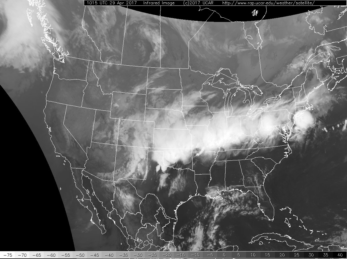
Weather conditions are somewhat tranquil across Alabama this morning while the weather was anything but tranquil along a front that stretched from a surface low near Wichita Falls to northern New York. Numerous severe thunderstorm and flash flood warnings were posted overnight along and just north of that front encompassing many counties from the Central Plains states into the Ohio River Valley area. Temperatures were very mild for late April with temperatures just before 6 am in the lower 70s. Highs today should climb into the upper 80s.
The big news today will be the warm weather together with high wind. Much of Alabama and Mississippi were under wind advisories today as the pressure gradient tightens up between the surface high to the east over the Atlantic and the surface low over North Central Texas. The tightening pressure gradient and the onshore flow were setting up excellent conditions for rip tides along the beaches of Mississippi, Alabama, and Northwest Florida, so if you are at the beach or headed that way, be very careful about swimming in the Gulf of Mexico.
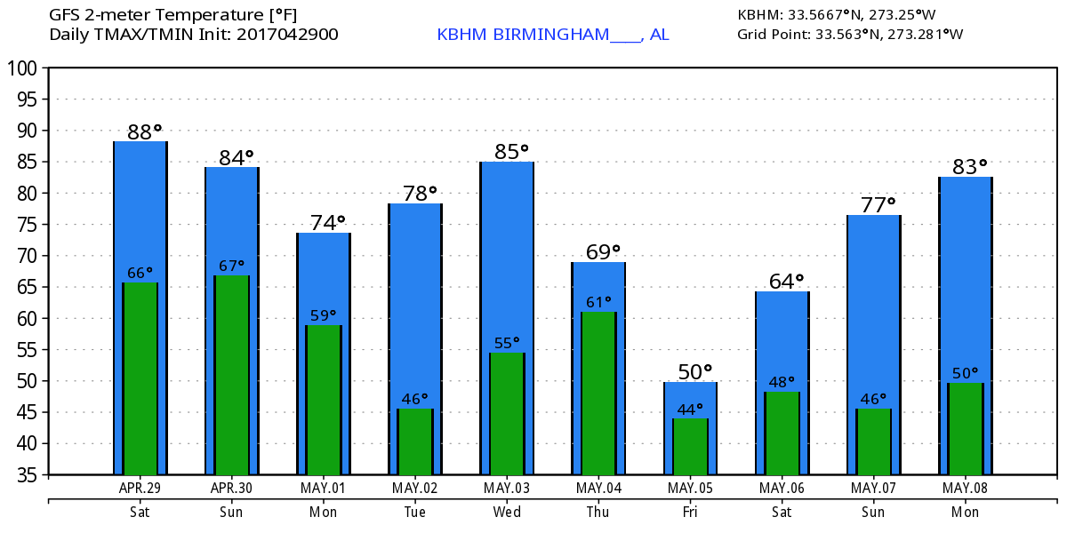
The weather will be fairly good much of the daylight hours for Sunday notwithstanding the wind issue as strong southerly wind will continue. Clouds will increase so temperatures should be held down into the lower and middle 80s. The strong closed low over New Mexico on Saturday will begin to pull northeastward reaching Central Kansas by midday Sunday. The surface low will reach Northeast Kansas with the front pushing well eastward to the Mississippi River by midday. Much of the eastern two thirds of Alabama is under the standard slight risk for severe storms late Sunday afternoon through early Monday morning. CAPE and helicity values support the potential for all modes of severe weather. While it looks like we’ll be dealing with a squall line, model soundings suggest the potential for tornadoes embedded in the squall line. See the video for the graphics of CAPE and helicity.
The upper low reaches Wisconsin on Monday as the front approaches the East Coast of the US. The weather across Alabama should be improving throughout the day with the potential to see some sunshine by late afternoon. Temperatures will fall back plenty as northwesterly flow begins to affect the area with highs only in the 70s – actually quite nice.
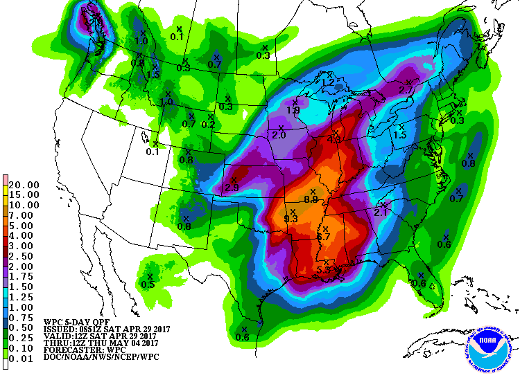
The upper air pattern flattens a little Tuesday and we see upper air ridging on Wednesday. By Wednesday though our attention is drawn to another strong trough digging into the Texas Panhandle. By Thursday the trough has dug into eastern Oklahoma and closed off with a surface low over Memphis. This certainly has the look for another round of severe storms on Thursday, but since there are still model differences and several timing issues, no specific area has been outlined yet. Maybe we’ll see an area defined as we get closer to the event and differences in the model solutions resolve themselves.
So look for another round of storms mainly on Thursday. Rainfall through these two systems could be substantial. QPF charts suggest 2 to 4 inches of rain is possible across the northern half of Alabama through Thursday morning.
The upper closed low is going to take its time as it moves slowly across the Southeast US on Friday keeping the weather unsettled and cool with highs only in the 60s. The low finally reaches Northwest Georgia on Saturday, so our weather should be improving and warming up.
Looking further afield, the closed upper low remains nearly stationary all the way into Tuesday before a new system dives into the southern Rockies helping to kick it out. By 348 hours or May 13th the pattern has gone to an upper ridge for the eastern half of the country bringing a return of warm weather.
Weather at the beach will be fine today, but the strong onshore flow is setting up excellent conditions for rip tides, and the onshore flow will keep rip tides likely through early Monday. Storms are likely Sunday afternoon into Monday morning. Temperatures remain nice with highs around 80. Click here to see the Beach Forecast Center page. Save Up To 25% on Spring Break Beach Vacations on the Alabama Gulf Coast with Brett/Robinson! The Beach Forecast is partially underwritten by the support of Brett/Robinson Vacation Rentals in Gulf Shores and Orange Beach. Click here to see Brett/Robinson’s best beach offers now!
Thanks for tuning in. I anticipate putting together another Weather Xtreme Video first thing on Sunday morning. Remember, check back often for news and notes on Alabama’s weather. Be sure to come out to Celebrate Hoover Day at Veteran’s Park today. I’ll be there at the ABC 3340 booth, so stop by and say hello. Have a great day, don’t get blown away, and Godspeed.
-Brian-
Category: Alabama's Weather, ALL POSTS, Weather Xtreme Videos
About the Author (Author Profile)
Brian Peters is one of the television meteorologists at ABC3340 in Birmingham and a retired NWS Warning Coordination Meteorologist. He handles the weekend Weather Xtreme Videos and forecast discussion and is the Webmaster for the popular WeatherBrains podcast.Subscribe
If you enjoyed this article, subscribe to receive more just like it.


