

Radar Update at 10 a.m.
Two mesoscale convective vortices are pushing north and northeast across Central Mississippi at this hour.
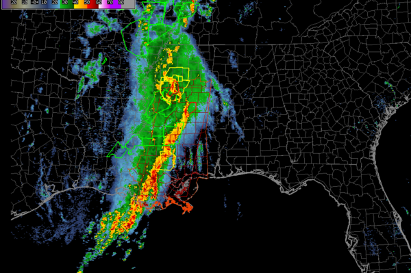
The first, responsible for tornado damage from Vicksburg to northwest of Jackson and in the Durant area is approaching Winona MS now. Strong indictions of a tornado in extreme Northwest Attalla County MS, passing east of Vaiden. This possible tornado will move toward Kilmichael.
The second, that will impact Northwest and West Central Alabama, is moving through Scott and Newton counties east of Jackson. A tornado warning is in effect for the Philadelphia area. It has a TORNADO…OBSERVED tag meaning that there has been radar confirmation. This storm could impact Lamar and Pickens Counties as early as 11:30 a.m.
This activity should approach the Tuscaloosa area by 12:30 – 1p.m. and the Birmingham area around 2-2:30 p.m.
The first line should weaken as it pushes east of I-65.
A second wave of storms will arrive in West Alabama by 4 p.m. It will progress slowly across the state through the late afternoon and evening hours.
Category: Alabama's Weather, ALL POSTS
About the Author (Author Profile)
Bill Murray is the President of The Weather Factory. He is the site's official weather historian and a weekend forecaster. He also anchors the site's severe weather coverage. Bill Murray is the proud holder of National Weather Association Digital Seal #0001 @wxhistorianSubscribe
If you enjoyed this article, subscribe to receive more just like it.


