

The Latest on the Alabama Severe Weather Situation Just Before 11 a.m.
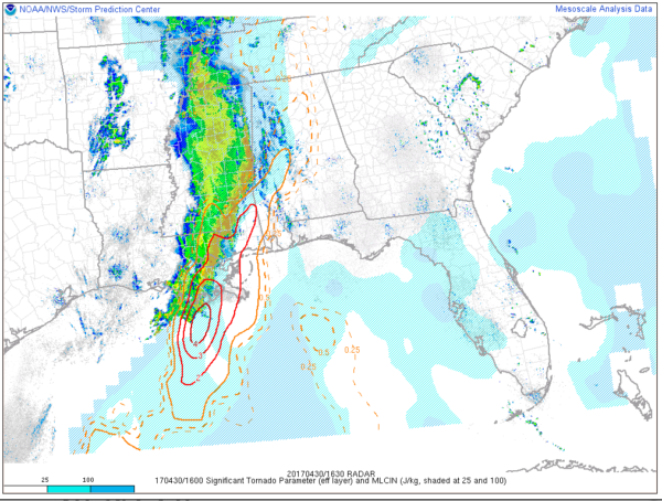
SIGTOR Parameter at 1145 a.m.
The airmass across Alabama is very warm and moist this morning. Temperatures are in the Upper 70s with some lower 80s across South Central Alabama. Dewpoints are high as well, with readings in the upper 60s across Central Alabama with some middle 60s mixed in with the upper 60s over the North. This is clearly sufficient for severe weather.
Skies are mostly cloudy, although a few breaks in the clouds will ensure that temperatures reach the 80s in all locations. So, warmth and moisture will not be an issue.
Let’s look at a few features/parameters:
JET STREAM
Our upper low is over Oklahoma and Kansas and the jetstream is spreading into Louisiana and Arkansas now. This will provide additional lift for storms late this afternoon and overnight.
LOW LEVEL JET
Winds are increasing now at 850 mb or 5,000 feet above the ground. This will provide additional low level shear over the next few hours.
SURFACE LOW
Weak surface low pressure covers eastern Kansas and western Missouri. This low will organize and deepen as it moves northeast this afternoon. By midnight tonight it will be near Kansas City with a with a minimum pressure of 994 mb.
INSTABILITY
CAPE values have increased to over 1,000 joules/KG over areas east of a line from Livingston to Tuscaloosa to Decatur.
SHEAR
Shear values are sufficient for severe storms over West Alabama at this time. Shear should increase eastward with time as well.
LOW LEVEL HELICITY
The low level helicity decreases the further east you head away from the Mississippi border.
LAPSE RATES
Mid level lapse rates are strong, while low level lapse rates are weak across much of Alabama. This means that updrafts will encounter favorable conditions once they get into the mid levels of the atmosphere.
SIGTOR
The Significant Tornado Parameter is above 1 which indicates the possibility of a significant tornado over West Central and Southwest Alabama.
HAIL
Hail shouldn’t be a problem at this point.
SPECIAL BALLOON RELEASE
The NWS Birmingham launched a special balloon just before noon. We will be interested in seeing what it sees.
BOTTOM LINE
Conditions are favorable for tornadoes and damaging winds over West Alabama right now. Instabilities are even more favorable the further east you go, so the storms should hold together. Wind shear values will be increasing with time the further east you go as well.
Category: Alabama's Weather, ALL POSTS
About the Author (Author Profile)
Bill Murray is the President of The Weather Factory. He is the site's official weather historian and a weekend forecaster. He also anchors the site's severe weather coverage. Bill Murray is the proud holder of National Weather Association Digital Seal #0001 @wxhistorianSubscribe
If you enjoyed this article, subscribe to receive more just like it.


