

Heads Up Walker, Winston and Cullman; Latest for Tuscaloosa and Jefferson
UPDATE 1 PM
Winds gusted to 56 mph at the Tuscaloosa Skycam shortly before 1 p.m.
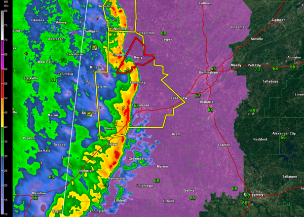
Another mesoscale convective vortex has formed over West Alabama this afternoon. This is the type of structure that produced what may have been a couple of long track tornadoes over western Mississippi this morning.
This system will have the potential to produce damaging winds and tornadoes across northern Tuscaloosa, Fayette, Walker, southeastern Winston and Cullman Counties over the next couple of hours.
For the City of Tuscaloosa, strong storms are moving into from the southwest. Winds to 45 mph, , pea sized hail, torrential rains and lots of lightning will accompany them.
For the Birmingham Metro, this is the same area of storms that will start moving through shortly before 2 p.m. Small hail, potentially damaging wind gusts, heavy rain and lightning will accompany the storm.
Category: Alabama's Weather, ALL POSTS
About the Author (Author Profile)
Bill Murray is the President of The Weather Factory. He is the site's official weather historian and a weekend forecaster. He also anchors the site's severe weather coverage. Bill Murray is the proud holder of National Weather Association Digital Seal #0001 @wxhistorianSubscribe
If you enjoyed this article, subscribe to receive more just like it.


