

Strong Storms Over South Alabama; Rain, Some Thunder North and Central
Temperatures have increased over the past couple of hours and dewpoints have as well across South Alabama ahead of our cold front. Pressures have also fallen, a sign of potential severe weather.
Montgomery is now 76/68F And the dewpoint at Troy is now 71F!
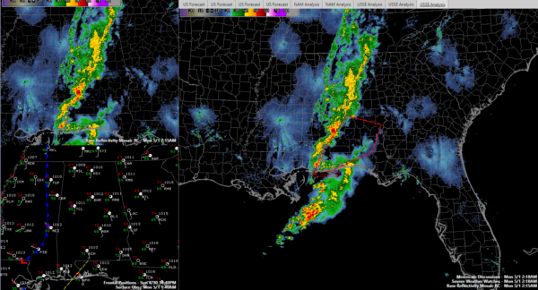
This is setting the stage for severe storms south of I-65 and I-85. The SPC says they probably want issue a watch, but there is a chance of damaging winds and an isolated tornado between Mobile, Montgomery, Eufaula and Dothan.
The strongest storms at this hour are over Wilcox and Monroe Counties. They will push toward Autauga and Lowndes Counties into the Montgoery area. These storms could eventually affect the Auburn area. Storms seem to be intensifying back into the Mobile area as well.
North of Montgomery, moderate to heavy rain and some embedded thunder will affect much of North and Central Alabama through the early morning hours.
The cold front has passed the Shoals, Haleyville Tuscaloosa and Demopolis.
This will be the last update tonight unless conditions change for Central Alabama.
Category: Alabama's Weather, ALL POSTS
About the Author (Author Profile)
Bill Murray is the President of The Weather Factory. He is the site's official weather historian and a weekend forecaster. He also anchors the site's severe weather coverage. Bill Murray is the proud holder of National Weather Association Digital Seal #0001 @wxhistorianSubscribe
If you enjoyed this article, subscribe to receive more just like it.


