

Rain Returns To Alabama Tonight
BIG WEATHER CHANGES AHEAD: Dry weather continues across Alabama today during the daytime hours with a warm afternoon… most communities will reach the mid 80s with a partly sunny sky. But, clouds will increase by evening, and wet weather returns tonight and tomorrow.
On their new severe weather outlook, SPC has a “marginal risk” of severe storms now defined for about the western half of Alabama, with the standard “slight risk” over the southwest corner of the state (this outlook is valid through 7:00 a.m. tomorrow).
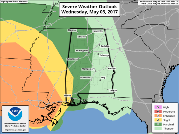
A large mass of rain should enter West Alabama sometime between 6:00 and 9:00 this evening… heavier storms will move into Southwest Alabama after midnight. High resolution model guidance suggests an organized band of severe storms, with potential for damaging straight line winds, will blow through Mobile and Baldwin Counties between 1:00 and 5:00 a.m.
This Gulf Coast “MCS” should prevent severe weather from becoming a problem for the northern half of the state. For places like Birmingham, Tuscaloosa, Anniston, and Gadsden we just expect a large area of rain overnight and little if any risk of severe weather.
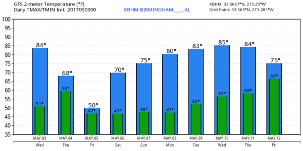
TOMORROW: There should be a break from the rain during a decent part of the morning, but more showers and storms will form by midday ahead of a surface cold front passing through. There will be very little surface based instability, and again the risk of severe weather looks very low for the northern half of the state. Tomorrow will be much cooler with temperatures holding in the 60s. And, rain amounts around 1 inch are likely for the northern half of the state, with storm totals over two inches possible for Southwest Alabama, where a flash flood watch is in effect.
COLD MAY DAY FRIDAY: Moisture wrapping around the back side of the departing storm system will keep clouds in place Friday, and we will need to mention periods of light rain as well. The day will be much cooler with temperatures holding in the 50s all day, almost 25 degrees below average for early May in Alabama.
THE WEEKEND: After a chilly start early Saturday morning with lows well down in the 40s, the weekend looks delightful with ample sunshine both days along with a warming trend. We reach the low 70s Saturday afternoon, followed by a high in the upper 70s Sunday.
RACE WEEKEND AT TALLADEGA: Friday will be windy and cool with overcast conditions; a few periods of light rain are likely. Afternoon temperatures will be only in the low to mid 50s. Then, bright sunny weather Saturday and Sunday with a warming trend; the high Saturday will be near 72, followed by 78 on Sunday.
NEXT WEEK: Afternoon temperatures warm back into the 80s, and the first half of the week will be dry. Global models are now suggesting that rain and storms will return at the end of the week on Friday (May 12). See the Weather Xtreme video for maps, graphics, and more details.
Click here to see the Beach Forecast Center page. Save Up To 25% on Spring Break Beach Vacations on the Alabama Gulf Coast with Brett/Robinson! The Beach Forecast is partially underwritten by the support of Brett/Robinson Vacation Rentals in Gulf Shores and Orange Beach. Click here to see Brett/Robinson’s best beach offers now!
WEATHER BRAINS: Don’t forget you can listen to our weekly 90 minute netcast anytime on the web, or on iTunes. This is the show all about weather featuring many familiar voices, including our meteorologists here at ABC 33/40.
CONNECT: You can find me on all of the major social networks…
Facebook
Twitter
Google Plus
Instagram
Pinterest
Snapchat: spannwx
Look for the next Weather Xtreme video here by 4:00 this afternoon… enjoy the day!
Category: Alabama's Weather, ALL POSTS, Weather Xtreme Videos
About the Author (Author Profile)
James Spann is one of the most recognized and trusted television meteorologists in the industry. He holds the AMS CCM designation and television seals from the AMS and NWA. He is a past winner of the Broadcast Meteorologist of the Year from both professional organizations.Subscribe
If you enjoyed this article, subscribe to receive more just like it.


