

The Nearest Rain to Alabama Is…Friday
It has been a gorgeous morning across Central Alabama with crystal clear skies for the most part and temperatures climbing through the 50s from cool, but comfortable morning lows. A few wisps of high cloudiness zipped across Northeast Alabama early this morning in the fast northwesterly flow aloft, but an upstream look on visible satellite imagery shows nothing all the way to North Dakota.
So brilliant sunshine, mild temperatures in the middle 70s, low humidity and light northerly winds means a great afternoon for the race at Talladega, gardening, golfing or whatever you have in mind. Get outside and enjoy!
MORNING LOWS: It was a very nice morning across Central Alabama this morning. Lows ranged from 46F at Muscle Shoals, Huntsville and Decatur to 53F at Montgomery. It was 50F at Tuscaloosa and Anniston and 51F at Birmingham and Calera. None of the major reporting stations across the state reported measurable rainfall yesterday from the disturbance that passed over the North and Northeast counties, but Huntsville and Decatur did record a trace of rain. Scottsboro did measure 0.01 inches and Valley Head recorded 0.03 inches from the fast moving showers. There was a CoCoRAHS report of 0.02 inches near Trussville in Northeast Jefferson County.
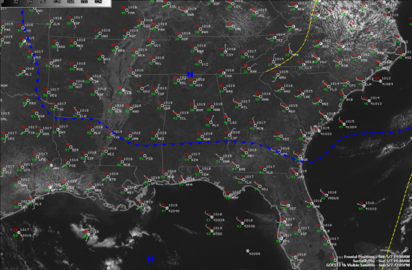
THAT’S SO UNUSUAL: This deep trough in May is unusual, and the little short wave trough that brought the showers and storms to the Smokies yesterday is now rotating off the North Carolina coast early this afternoon. A surface low associated with the disturbance it moving off the Virginia Capes. It is dragging a weak cold front through Alabama. That front is across South Central Alabama at this hour, but there is not much difference in airmass temperature wise. The difference lies in the humidity. Dewpoints north of the front are in the 30s, while they are in the 40s over South Alabama.
TEMPERATURE FORECAST: After several weeks of complex and tricky forecasts, this week will be a temperature forecast only. Middle 70s today, lower 80s Monday, upper 80s Tuesday through Thursday for highs. Lows will be in the upper 40s to near 50 tomorrow morning, and then in the 50s Tuesday morning and then lower 60s the rest of the week.
NEAREST RAIN TO ALABAMA: On national radars, the nearest rain to Alabama is over West Virginia. The nearest rain on the calendar is Friday. The ridge that is giving us the nice weather will build over Alabama through Tuesday and then start to slowly break down as disturbances ride up and over the top of it.
A trough will persist most all week over the Southwest, giving severe weather chances to the Plains. That trough will move to Oklahoma by late Thursday, setting the stage for changes for us here in Alabama. As this system swings across the Southeast, it will bring a round of showers and storms. The GFS brings the activity in Friday morning and moves it out quickly, while the European largely agrees on the commencement but moves it through more slowly, keeping Saturday showery. Stay tuned.
VOODOO TERRITORY: The GFS is hinting at a good wet weather system for Monday the 22nd. We definitely need it! Our current drought situation is only going to get worse in coming days I fear. 8 day precipitation totals through next weekend are running about one half to one inch according to the GFS. Two week totals are less than two inches for North Alabama with about 1.25 inches across the Central part of the state.
Category: Alabama's Weather, ALL POSTS
About the Author (Author Profile)
Bill Murray is the President of The Weather Factory. He is the site's official weather historian and a weekend forecaster. He also anchors the site's severe weather coverage. Bill Murray is the proud holder of National Weather Association Digital Seal #0001 @wxhistorianSubscribe
If you enjoyed this article, subscribe to receive more just like it.


