

Sunday’s Weather Xtreme Video: Off and On Rain Through Midweek
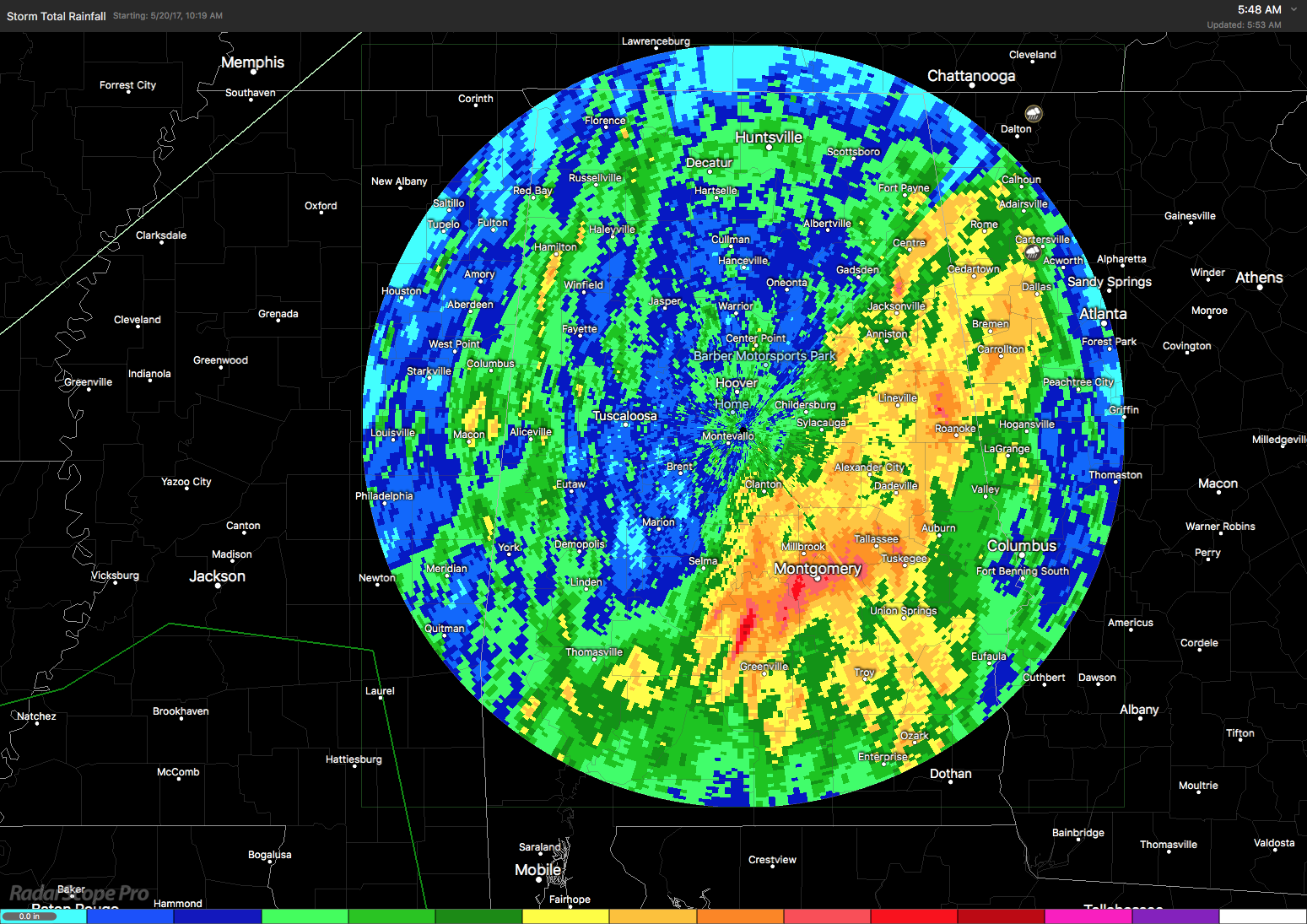
Rainfall yesterday was pretty spectacular in some places resulting in several flash flood warnings. I saw 2.29 inches of rain fall into my gauges, but that was almost nothing compared with the 7.24 inches of rain recorded at the Danelly Field in Montgomery. As you can see from the storm total precipitation estimates from the BMX WSR-88D, we put another pretty good dent in the overall drought conditions affecting Alabama.
The widespread rain from yesterday was producing some patchy fog across Central Alabama but the fog was not too thick and has not prompted any kind of dense fog advisory as most airport locations were reporting visibilities at 3 miles or above. But clouds left over from all that precipitation yesterday and early this morning was producing overcast skies. Clouds will help hold temperatures down a bit today with highs in the lower and middle 80s. Additional showers and thunderstorms are expected today and tonight, but rain is not expected to fall all day. Radar already showed numerous showers and thunderstorms in Mississippi as the surface front will make its way across the Southeast US today. Primary severe weather risk for Day 1 is back in Texas.
The upper trough will rotate into eastern Great Lakes region Monday as another short wave axis rotates southward behind the first one. This second short wave will dig into the Middle Mississippi River Valley on Tuesday and into the Southeast US on Wednesday. That primary feature along with a small short wave skirting across the Lower Mississippi River Valley and the Southeast US on Tuesday will combine to keep our weather wet and unsettled into early Thursday.
Rain and storms are expected today and tonight lingering into the first half of Monday. We should see a dry period on Monday afternoon extending into the early evening until rain arrives once again for the first half of Tuesday. Temperatures Monday will be in the lower 80s while Tuesday highs will be held in the upper 70s.
We dry out again during the second half of Tuesday until that digging trough bring rain and storms back into the picture primarily for the first half of Wednesday. But its going to be much cooler on Wednesday and Thursday as the upper trough digs into the Southeast US bringing some cooler air into the area with highs in the lower 70s on Wednesday and in the upper 70s Thursday. Lows Thursday morning are going to be in the 50s, pretty cool when compared with the 30-year average lows in the lower 60s.
The upper trough moves away on Thursday as an upper ridge becomes the main player in our upper air pattern by Friday and into the weekend. The ridge stays with us through Sunday promising dry conditions along with highs climbing back into the 80s.
Looking further out into week 2, often called voodoo country, the GFS is pretty bullish on keeping an upper ridge over the eastern half of the country with a trough along the West Coast states. But be sure to watch the video to see the tropical mischief the GFS is brewing.
REGIONS TRADITION: The Regions Tradition continues today at the Greystone Golf and Country Club and tickets remain on sale. Fans and golfers will have to dodge a few showers and storms today, but they should get the rounds in. Come see some of the world’s greatest golfers such as Bernhard Langer, John Daly, Freddie Couples and many more right in our own backyard. Tickets start at only $20. Also, children 18 and under are admitted free with a ticketed adult!
SEC BASEBALL: The SEC Baseball Tournament returns to the Hoover Met, May 23-28. Come see some of the best college players in the country as they compete for the championship. Also, for the first time ever, you can take advantage of the Hoover Metropolitan Complex which will feature a free, indoor Fan Fest – ferris wheel, sports bar and much more! Tickets start at only $9! For now it looks like some light rain Wednesday, otherwise the weather looks good with temperatures below average.
HANGOUT MUSIC FESTIVAL: Showers and thunderstorms are possible at Gulf Shores today and they will get the concerts in, but just be ready for a lightning delay or two today. The weather will stay wet until about Wednesday when we see some improvements. Click here to see the Beach Forecast Center page. Save Up To 25% on Spring Break Beach Vacations on the Alabama Gulf Coast with Brett/Robinson! The Beach Forecast is partially underwritten by the support of Brett/Robinson Vacation Rentals in Gulf Shores and Orange Beach. Click here to see Brett/Robinson’s best beach offers now!
WEATHER BRAINS: Don’t forget you can listen to our weekly 90 minute netcast anytime on the web, or on iTunes. This is the show all about weather featuring many familiar voices, including our meteorologists here at ABC 33/40.
I had a great time visiting with folks at Altoona Day yesterday along with Meaghan Thomas. Special thanks for inviting us to be there to participate in a wonderful festival. James Spann will have the next Weather Xtreme Video posted here on Monday morning. Godspeed.
-Brian-
Category: Alabama's Weather, ALL POSTS, Weather Xtreme Videos
About the Author (Author Profile)
Brian Peters is one of the television meteorologists at ABC3340 in Birmingham and a retired NWS Warning Coordination Meteorologist. He handles the weekend Weather Xtreme Videos and forecast discussion and is the Webmaster for the popular WeatherBrains podcast.Subscribe
If you enjoyed this article, subscribe to receive more just like it.


