

Wet, Unsettled Pattern Through Wednesday
RADAR CHECK: We have just a few widely scattered showers across Alabama early this morning, but a very moist airmass remains in place across the Deep South, and we will forecast several rounds of showers and storms for the state through Wednesday.
Due to potential for heavy rain at times, a flash flood watch is in effect for roughly the southern half of Alabama…

Additional rain amounts of 2 to 4 inches are possible for the southern half of the state through Wednesday night; amounts of 1-2 inches are expected for the northern counties.
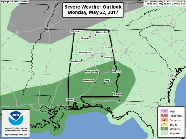
We should also mention there is a “marginal risk” of severe thunderstorms for South Alabama later today and tonight; hail and gusty winds will be possible in the heavier thunderstorms (the tornado threat for now looks very low)…
TIMING: The first round of organized showers and storms for the state will come this afternoon, tonight, and possibly into tomorrow morning. Heaviest rain and stronger storms will be over the southern half of the state, but all of Alabama will see more beneficial rain.
A break in the rain is very possible through the midday and afternoon hours tomorrow, but more rain will arrive tomorrow night ahead of a deep upper trough and surface cold front.
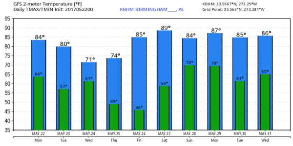
RECORD LOW MAXIMUM POSSIBLE WEDNESDAY: Wednesday will be cloudy and very cool for late May in Alabama, and many North Alabama communities will have a hard time getting out of the 60s. The record low maximum temperature for Birmingham on May 24 is 73 degrees set in 2000… and that is very much in danger. We will mention a chance of some light rain at times Wednesday as the deep upper trough passes over, but amounts won’t be too heavy for the northern counties of the state. A few strong storms are possible Wednesday over Southeast Alabama ahead of the surface front… a “marginal risk” of severe storms is in place there.
THURSDAY/FRIDAY: Thursday morning will be cool with potential for lows in the 40s in many places… Birmingham’s record low for May 25 is 45 set in 1979… I doubt it gets that cool in the city, but colder pockets in outlying areas will see mid 40s. Thursday will be a partly to mostly sunny day with a high in the mid 70s; Thursday night will be cool again, and colder spots will visit the 40s again early Friday morning.
Then, we warm back into the 80s Friday afternoon under a strong May sun.
THE ALABAMA WEEKEND: For now Saturday looks warm and dry with a partly sunny sky; temperatures rise into the mid to upper 80s by afternoon. Moisture levels will be rising, however, and a few showers are possible by Saturday night. Then, on Sunday, the sky will be mostly cloudy with a chance of showers and thunderstorms; Sunday’s high will be in the low to mid 80s.
NEXT WEEK: Memorial Day looks wet at times; we will need to maintain the risk of a few showers and thunderstorms during the day; Tuesday and Wednesday look drier. See the Weather Xtreme video for maps, graphics, and more details.
SEC BASEBALL: The SEC Baseball Tournament returns to the Hoover Met this week; the games begin tomorrow. Come see some of the best college players in the country as they compete for the championship. Also, for the first time ever, you can take advantage of the Hoover Metropolitan Complex which will feature a free, indoor Fan Fest – ferris wheel, sports bar and much more! Tickets start at only $9! A few showers are possible tomorrow and Wednesday; the weather looks great Thursday through Saturday. Then, there will be some risk of showers and storms at the Hoover Met Sunday, but they should be able to get all the games in.
Click here to see the Beach Forecast Center page. Save Up To 25% on Spring Break Beach Vacations on the Alabama Gulf Coast with Brett/Robinson! The Beach Forecast is partially underwritten by the support of Brett/Robinson Vacation Rentals in Gulf Shores and Orange Beach. Click here to see Brett/Robinson’s best beach offers now!
WEATHER BRAINS: Don’t forget you can listen to our weekly 90 minute netcast anytime on the web, or on iTunes. This is the show all about weather featuring many familiar voices, including our meteorologists here at ABC 33/40. We will produce this week’s show tonight at 8:30 CT… you can watch it live here.
CONNECT: You can find me on all of the major social networks…
Facebook
Twitter
Google Plus
Instagram
Pinterest
Snapchat: spannwx
I have a weather program (this last one for the 2016-17 school year) this morning at Our Lady of Sorrows Catholic School… be looking for the next Weather Xtreme video here by 4:00 this afternoon. Enjoy the day!
Category: Alabama's Weather, ALL POSTS, Weather Xtreme Videos
About the Author (Author Profile)
James Spann is one of the most recognized and trusted television meteorologists in the industry. He holds the AMS CCM designation and television seals from the AMS and NWA. He is a past winner of the Broadcast Meteorologist of the Year from both professional organizations.Subscribe
If you enjoyed this article, subscribe to receive more just like it.


