

Severe Threat Overnight; Severe Thunderstorm Watch Issued for North Alabama
A severe thunderstorm watch has been issued for North Alabama until 5 a.m. CDT. It will include counties as far south as Marion, Winston, Cullman, Blount, Etowah and Cherokee.
On this date in 1973, the second longest track tornado in Alabama history had lifted within the hour near Mt. Cheaha after devastating Brent and taking out the NWS radar at Centerville.
Forty four years later, we are dealing with a multiple day severe weather threat here in Alabama. It takes a pretty anomalous trough to make severe weather in late May in Alabama, and we have another trough pushing our way.
Tornado and severe thunderstorm watches extend all the way from eastern Oklahoma through the Ohio Valley to West Virginia and North Carolina with additional severe thunderstorm watches in eastern Virginia and North Carolina.
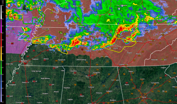
Severe storms extend across southern Missouri in association with an upper level disturbance, across Central Tennessee in association with another shortwave trough over Northeast Tennessee. These storms are sinking south and will reach the Tennessee Valley of North Alabama before midnight. They will maintain an enhanced risk of damaging winds as they drop into North Alabama.
The storms should weaken as they drop south into North Central Alabama and should no longer be severe as they reach the Birmingham area around 5 a.m. But we will be watching through the overnight hours and will have continual updates.
Additional storms will drop into Northwest Alabama during the morning, but they should be under severe limits.
Category: Alabama's Weather, ALL POSTS
About the Author (Author Profile)
Bill Murray is the President of The Weather Factory. He is the site's official weather historian and a weekend forecaster. He also anchors the site's severe weather coverage. Bill Murray is the proud holder of National Weather Association Digital Seal #0001 @wxhistorianSubscribe
If you enjoyed this article, subscribe to receive more just like it.


