

Humid With A Few Showers/Storms
MEMORIAL DAY: I hope you take some time to remember what this day represents. May we never forget that freedom isn’t free. In terms of weather… the day will feature more clouds than sun, and we will have the risk of a few passing showers or thunderstorms through tonight. Not a continuous rain, however. If you have something planned outside, just be ready for an occasional shower or thunderstorm.
Some of the the heavier storms were over the Florida Panhandle at just after daybreak…
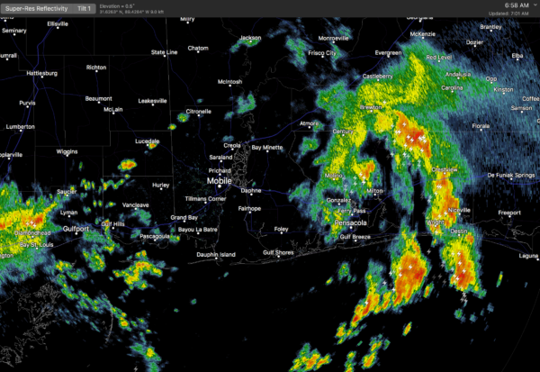
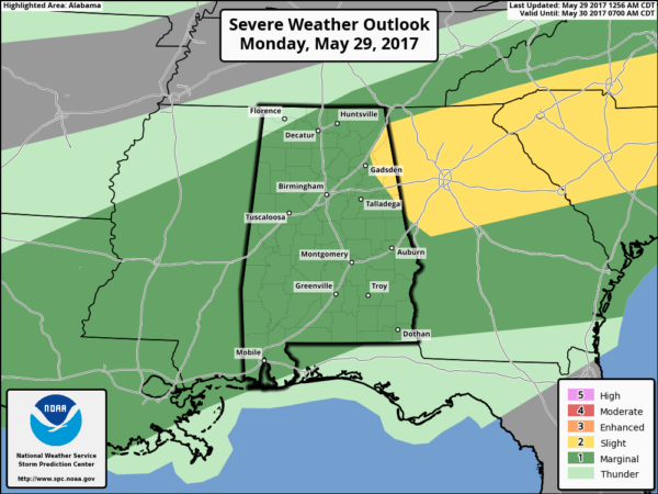
Rain over the northern half of the state is light and spotty early this morning. Storms that form later today could be strong; SPC has much of Alabama in a “marginal risk” of severe weather…
Surface based CAPE values could exceed 2,000 j/kg in spots this afternoon, but with only a limited amount of sunshine and weak wind fields, the overall severe weather threat looks pretty low for now.
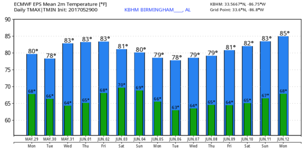
REST OF THE WEEK: A surface front north of here has stalled, and will dissipate before reaching Central Alabama, so we stay in a moist airmass through the week. This means we will need to mention some risk of scattered showers and thunderstorms on a daily basis through Friday. Remember, meteorological summer begins this week, meaning cold front passages will be fewer in number, and you will hear of “scattered, mostly afternoon and evening showers and thunderstorms” almost daily. Highs this week will be mostly in the low to mid 80s, close to seasonal averages.
THE WEEKEND: Not much change. A mix of sun and clouds Saturday and Sunday with scattered showers and storms possible both days. Highs in the mid 80s.
Trying to determine changes in the overall coverage and timing of scattered showers and storms is very challenging more than a day in advance in summer.
STORM DAMAGE OVER THE WEEKEND: Straight line wind damage was reported in at least a dozen North Alabama counties during the pre-dawn hours Sunday. The NWS Birmingham released this statement concerning concentrated damage at Hamilton…
“After discussion of the damage with Marion County Emergency Management and radar analysis, the damage appears to be consistent with straight-line winds. At this time, no storm surveys are planned from our office.”
BEACH FORECAST: Click here to see the AlabamaWx Beach Forecast Center page. The Beach Forecast is partially underwritten by the support of Brett/Robinson Vacation Rentals in Gulf Shores and Orange Beach. Click here to see Brett/Robinson’s Own Your Summer specials now!
WEATHER BRAINS: Don’t forget you can listen to our weekly 90 minute netcast anytime on the web, or on iTunes. This is the show all about weather featuring many familiar voices, including our meteorologists here at ABC 33/40. We will produce this week’s episode tonight at 8:30… you can watch it live here.
CONNECT: You can find me on all of the major social networks…
Facebook
Twitter
Google Plus
Instagram
Pinterest
Snapchat: spannwx
We are on a holiday schedule… so just one video today, but I will post fresh forecast notes here on the blog by 4:00. Enjoy the day!
Category: Alabama's Weather, ALL POSTS, Weather Xtreme Videos
About the Author (Author Profile)
James Spann is one of the most recognized and trusted television meteorologists in the industry. He holds the AMS CCM designation and television seals from the AMS and NWA. He is a past winner of the Broadcast Meteorologist of the Year from both professional organizations.Subscribe
If you enjoyed this article, subscribe to receive more just like it.


