

Heading into an Unsettled Spell
The Southeast US is split this morning with cloudy skies across much of Georgia and Florida while the western portions remain mostly clear. Temperatures this morning were mainly in the 60s. The large surface high continued to slide slowly eastward, so increasing moisture levels is still underway. By this afternoon dew point readings will be in the upper 60s. We’ll see a mixture of sun and clouds with highs climbing close to the 90-degree mark. Showers will be fairly common along the coastal area and southern Alabama while only isolated showers are expected across North and Central Alabama.
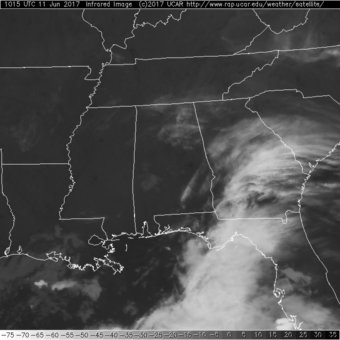
The tropical Atlantic remained quiet this morning with no areas of interest for forecasts. The area of disturbed weather just off the coast of extreme southern Mexico continued to remain close to show and had become better organized. Locally heavy rains will occur in this area with slow development of the area expected for the next couple of days.
The weak upper air disturbance we noted yesterday over eastern Texas remained a player in our weather for the week ahead. The problem with these relatively weak systems is trying to track their specific locations. The GFS tries to do that but the overall weakness is difficult to find on the forecast charts. Nevertheless, the combination of high moisture values with precipitable water values near 2 inches, the weakness aloft, and daytime heating will be working to bring us a fairly wet week. Just remember that the character of the weather will be showers so you might not see rain at your specific location every day, but showers are expected to be pretty widespread and common especially during the afternoon and early evening hours.
The upper air weakness will meander generally under the strong upper ridge who axis pushes northward into the eastern Great Lakes region. By the end of the week, the upper ridge moves off the East Coast of the US as a fairly strong trough and closed low move across Canada. By Friday and into the weekend, our upper flow goes northwesterly lowering the heights over the eastern part of the country and keeping temperatures warm but not especially hot. Watch the video as we try to follow the meandering progress of the weak upper low that should aid in keeping the weather unsettled for the week ahead.
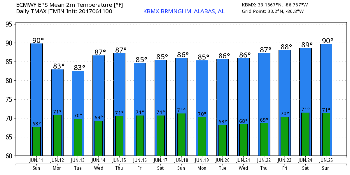
The highs for Central Alabama are going to be primarily in the upper 80s. Day-to-day variations will occur due to the exact timing of lower initiation and the amount of cloud cover we see. Should showers form near an observing station around noon, the high for the day for that location may be capped around the middle 80s. But stations that remain away from showers will climb close to the 90-degree mark.
Scattered storms are in the forecast along the Gulf Coast, too, but it won’t be a washout. Water temperatures along the Gulf beach area have risen nicely with most spots showing readings in the 80s. For a detailed look at the weather from Fort Morgan to Panama City Beach, click here to see the AlabamaWx Beach Forecast Center page. The Beach Forecast is partially underwritten by the support of Brett/Robinson Vacation Rentals in Gulf Shores and Orange Beach. Click here to see Brett/Robinson’s Own Your Summer specials now!
As you probably guessed, the GFS has changed the outlook for voodoo country. This run of the GFS is much more bullish on keeping a broad trough over the eastern portion of the US with the ridge situation primarily along the Rockies. This run does keep some Gulf mischief in the forecast, but this run fixes the location of a disturbance primarily over the western Gulf of Mexico. And as you’ll see in the graphics, it is not very strong.
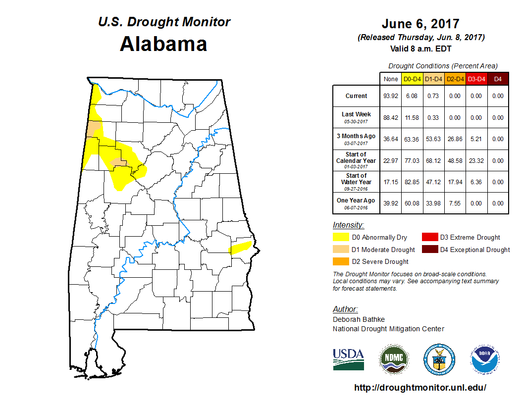
The Drought Monitor issued on Thursday continued to have good news for Alabama with the amount of drought affected area down to slightly less than 7 percent. Rain in Florida also helped out the Sunshine State with drought conditions across the Peninsula reduced but still of concern.
I had a great time visiting with folks in Centre in Cherokee County yesterday for the Cherokee County Medical Center’s 60th anniversary. Was able to program a number of weather radios, too. James Spann will be back with the next edition of the Weather Xtreme Video first thing Monday morning. I’ll be filling in once again on ABC 3340 News today at 5 and 10 pm, so be sure to check in for the latest weather forecast. Have a great day and Godspeed.
-Brian-
Category: Alabama's Weather, ALL POSTS
About the Author (Author Profile)
Brian Peters is one of the television meteorologists at ABC3340 in Birmingham and a retired NWS Warning Coordination Meteorologist. He handles the weekend Weather Xtreme Videos and forecast discussion and is the Webmaster for the popular WeatherBrains podcast.Subscribe
If you enjoyed this article, subscribe to receive more just like it.


