

Flooding, Slight Risk Area Expanded and Tropical Mischief for Father’s Day
LATE NOTE AT 1235PM
The Air Force Reserve mission into the broad low pressure center east of the Yucatan Peninsula for today has been canceled. But there is still a high probability of a cyclone forming over next 48 hours (70 percent).
HAPPY FATHER’S DAY! It’s our special day to recognize all the dads out there. Thanks for everything that you’ve done and do to make us into men, Dad!
FATHER’S DAY FLOODING: Unfortunately, heavy rain has been the order of the day across the Montgomery area. A weakening upper level low and left over mesoscale convective vortex from earlier storms over South Alabama led to persistent of showers and storms through the morning hours that dropped over three inches of rain across a wide area from Lowndes and Montgomery Counties across Autauga and into Chilton and even Clay Counties.
There was a bullseye of over five inches northwest of Prattville. This prompted flash flood warnings for parts of Elmore, Montgomery, Autauga and Lowndes Counties that are now areal flood warnings that will last into mid-afternoon. The rain was slowly tapering off, but there are several reports of flooded roads, including US-82 northwest of Prattville. More heavy rain was developing fro west of Montgomery southward along US-331.
Moisture levels are very high with precipitable water values near two inches in that area so rainfall rate of over two inches per hour could dump five more inches of rain in spots that are already saturated and more flooding is likely.
Remember the familiar adage: Turn Around, Don’t Drown. Being on time isn’t worth it if it puts your life or the life of others in danger
THEN TO THE NORTHWEST: Additional showers and storms had formed by late morning over Northwest Alabama ahead of a cold front that is slowly working its way toward Memphis. The upper trough over the Midwest is trying to dig down into the Southeast, aided by a strong upper level disturbance sliding along its southern periphery. As this little spinner slides eastward, it is triggering strong storms and a severe thunderstorm watch is in effect for much of Arkansas until 4 p.m.
Temperatures aloft are colder over Mississippi and that is spreading into Alabama, leading to increased instability and the development of showers and storms over Northwest Alabama. Wind shear is light, and storms shouldn’t be able to organize effectively, so widespread severe weather isn’t expected. But a few of the storms could briefly become severe and will all produce dangerous lightning, very heavy rain and isolated damaging wind gusts.
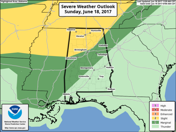
SEVERE WEATHER RISK: The SPC maintains a marginal risk (level 1 of 5) over the northwestern two thirds of Alabama and a slight risk (level 2 of 5) for areas northwest of I-59. This is for the activity over Arkansas that may become better organized and come into Alabama late this afternoon. Storms could reach Northwest Alabama by 5 p.m. and weaken as they push southeast during the evening. Damaging winds would be the primary threat. The only threat of any large hail is over the Northwest Corner of the state.
THREAT FOR MONDAY: The front will reach the Northwest Corner of Alabama around sunrise tomorrow and will stall out across Central Alabama by late afternoon. This will allow for another round of showers and storms on Monday. The SPC already has a marginal risk (level 1 of 5) of severe weather for Monday across the northwestern two thirds of the state. Damaging winds will be the main threat again.
TROPICAL MISCHIEF: An Air Force Hurricane Hunter plane will investigate the disturbance near the Yucatan Peninsula this afternoon with another plane scheduled for overnight tonight. The morning run of the GFS shows a steadily developing low pressure system forming later today northeast of the Yucatan and plodding northeastward toward Louisiana. The system stalls over Southeast Louisiana Wednesday and Thursday and eventually comes northeast of Friday, bringing us more rain.
It doesn’t look like the system will be able to become a hurricane, with decent wind shear across the northern Gulf, but it could become a tropical storm. If it does it will be Bret or Cindy. The uncertainty is because there is another system about 1000 miles east south of the Lesser Antilles that could become a tropical cyclone as well. It should reach the islands late Tuesday. An Air Force Plane will investigate tomorrow. My money is on the Gulf system being Bret.
EFFECTS ON REST OF WEEK WEATHER: The potential tropical cyclone shouldn’t have any impact on Central Alabama’s weather through Thursday. But the stalled front, high moisture levels will keep our rain chances high through then. The best chances look like they will come today, tomorrow and on Tuesday.
If the Gulf low materializes, our rain chances could really go up on Friday into the weekend. Rainfall amounts could average over two inches through Thursday another 1.5 inches or more Friday into Saturday. Temperatures will be warm, with highs in the middle 80s and lows in the lower 70s head of the front, and upper 60s behind it.
Category: Alabama's Weather, ALL POSTS
About the Author (Author Profile)
Bill Murray is the President of The Weather Factory. He is the site's official weather historian and a weekend forecaster. He also anchors the site's severe weather coverage. Bill Murray is the proud holder of National Weather Association Digital Seal #0001 @wxhistorianSubscribe
If you enjoyed this article, subscribe to receive more just like it.


