

Clouds Are Causing A Big Difference In Temperatures At Midday
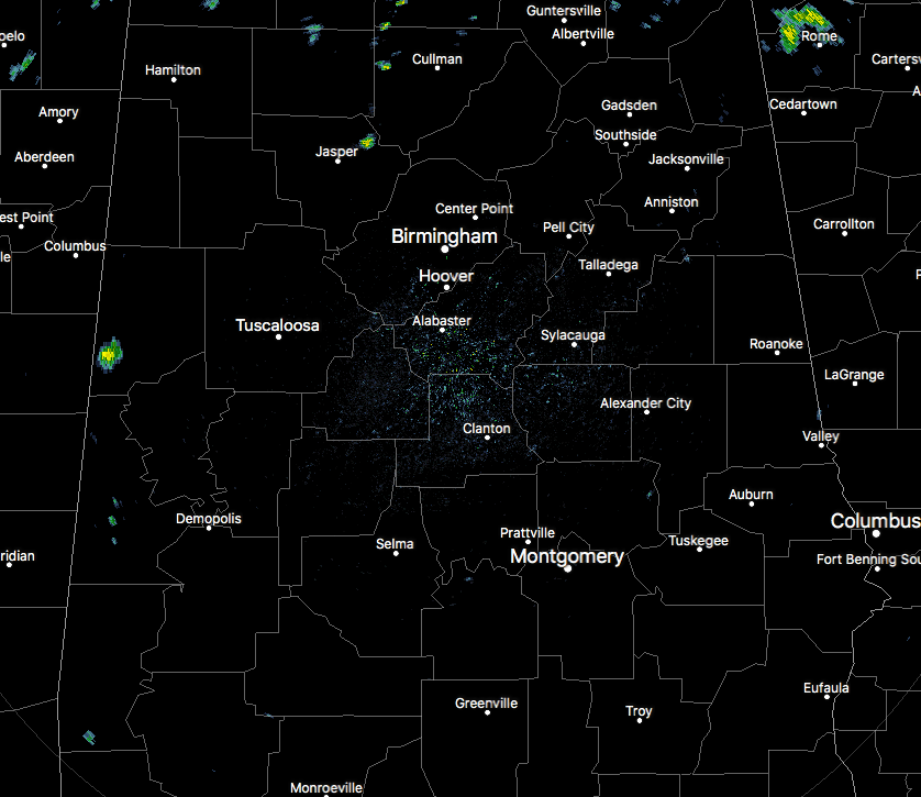
RADAR CHECK AT 11:20AM
Currently across Central Alabama, we are mostly dry area-wide, but a few isolated showers are dotting the radar at this time. We have a few of those that have popped up in parts of Cullman and Walker counties in the northern part of the area, and a few more have popped up in the western parts of the area in parts of Pickens and Sumter counties.
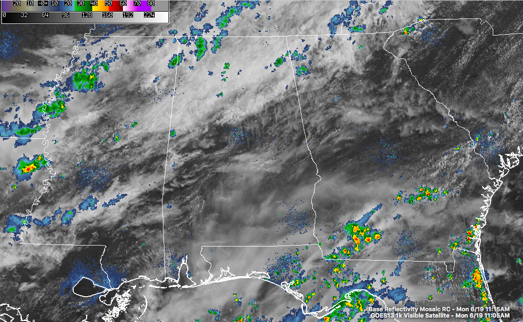
Across the state, skies are mostly cloudy with the exception of a strip of partly cloudy skies running from the southwestern parts of the state to the northeast. The cold front is very close to entering the northwest corner of the state, and along the front there are a few showers that have formed, but nothing too impressive. That front is expected to slowly move southward across Central Alabama and should stall out just south of Birmingham with the next 24 hours.
We’ll have showers and storms form on and ahead of the front this afternoon and evening, with some of the storms becoming strong to marginally severe, with damaging thunderstorm wind gusts as the main threat. SPC has nearly all of Central Alabama in a Marginal Risk for severe storms throughout the remainder of the day. The best chance for those scattered showers and storms will be along and around the I-20/59 in Western Alabama and the I-59 corridor in Northeast Alabama. Rain chances will be smaller everywhere else. Afternoon highs will be in the mid 80s to at or near 90 degrees, with lows in the upper 60s to the lower 70s.
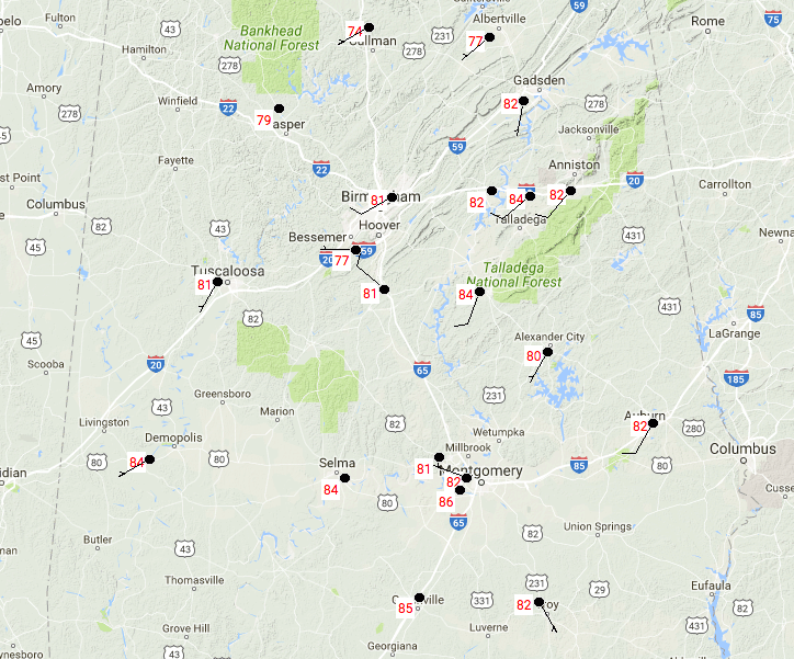
TEMPERATURES AT 11:30am
Temperatures across Central Alabama are currently running in the mid 70s to the mid 80s, with the cloud cover causing the large discrepancies in the numbers. Montgomery is currently the warm spot at 86 degrees, with Cullman as the cool spot at 74 degrees.
RAIN AND STORMS ARE STILL LIKELY ON TUESDAY
The cold front that will be stalled out over the area will actually lose its dynamic support and will diminish after slowly drifting southward. The focus of the shower and storm activity will mainly be along and south of the I-20 corridor, but the possibility is there for a shower or two north of that. Highs will be in the lower to mid 80s for most, with a few locations in the western parts of the area reaching the upper 80s.
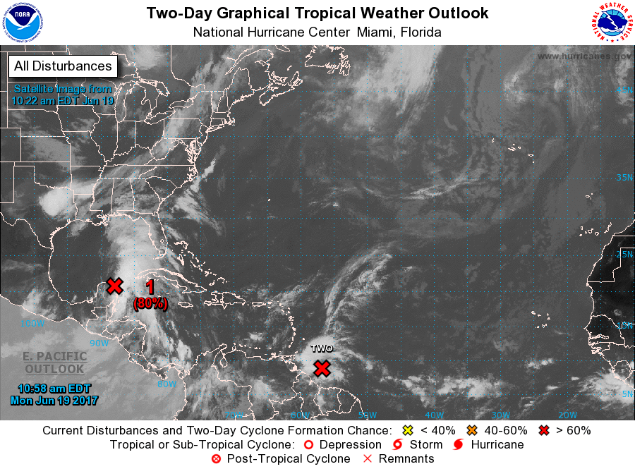
A LOOK AT THE TROPICS
The broad area of low pressure that is near the east coast of the Yucatan Peninsula is expected to move towards the central Gulf Coast, and will likely develop into a depression and/or a storm. The second area of concern now has been classified as “Potential Tropical Cyclone Two,” and is forecasted to strengthen to a tropical storm as it hugs the northern coastline of South America while heading west-northwest towards Central America. Should be no threat to the southeast (at this point).
HEADING TO THE BEACH
For a detailed look at the weather from Fort Morgan over to Panama City Beach, click here to see the AlabamaWx Beach Forecast Center page. The Beach Forecast is partially underwritten by the support of Brett/Robinson Vacation Rentals in Gulf Shores and Orange Beach. Click here to see Brett/Robinson’s Own Your Summer specials now!
TODAY IN WEATHER HISTORY
June 19, 1972 – Hurricane Agnes moved onshore near Cape San Blas FL with wind gusts to 80 mph, and exited Maine on the 26th. There were 117 deaths, mainly due to flooding from North Carolina to New York State, and total damage was estimated at more than three billion dollars. Up to 19 inches of rain deluged western Schuylkill County PA. The rains of Hurricane Agnes resulted in one of the greatest natural disasters in U.S. history. Agnes caused more damage than all other tropical cyclones in the previous six years combined.
WEATHERBRAINS
This week, the panel entertained two satellite experts who talked about GOES-16. The show went nearly three hours! Don’t forget you can listen to our weekly 90 minute netcast anytime on the web, or on iTunes. This is the show all about weather featuring many familiar voices, including our meteorologists here at ABC 33/40. you can watch it live here on Monday nights at 8:30PM CDT.
Category: Alabama's Weather, ALL POSTS
About the Author (Author Profile)
Scott Martin is an operational meteorologist, professional graphic artist, musician, husband, and father. Not only is Scott a member of the National Weather Association, but he is also the Central Alabama Chapter of the NWA president. Scott is also the co-founder of Racecast Weather, which provides forecasts for many racing series across the USA. He also supplies forecasts for the BassMaster Elite Series events including the BassMaster Classic.Subscribe
If you enjoyed this article, subscribe to receive more just like it.


