

Tropical Storm Bret Moving Across Trinidad and Tobago
Tropical Storm Bret is moving Trinidad and Tobago tonight with top winds of 40 mph.
The storm will track just north of the coast of Venezuela overnight and Tuesday morning. The impact of the air flow off the land mass and increasing wind shear will eventually weaken the storm and it should lose its tropical storm status by early Wednesday. It will likely degenerate into an open wave and not reform.
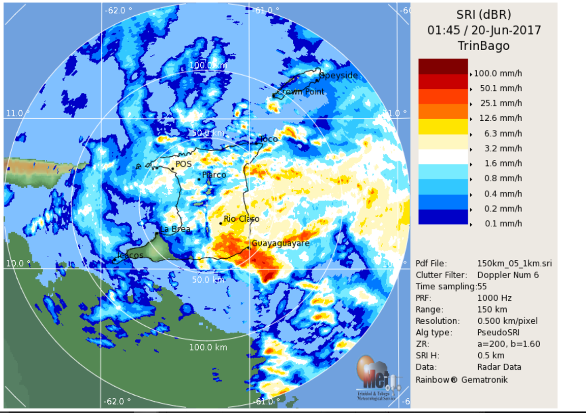
Here is an image from the Weather Service of Trinidad and Tobago:
SUMMARY OF 1100 PM AST…0300 UTC…INFORMATION
———————————————–
LOCATION…10.0N 61.3W
ABOUT 30 MI…45 KM S OF TRINIDAD
ABOUT 150 MI…235 KM S OF GRENADA
MAXIMUM SUSTAINED WINDS…40 MPH…65 KM/H
PRESENT MOVEMENT…WNW OR 285 DEGREES AT 23 MPH…37 KM/H
MINIMUM CENTRAL PRESSURE…1008 MB…29.77 INCHES
WATCHES AND WARNINGS
——————–
CHANGES WITH THIS ADVISORY:
None.
SUMMARY OF WATCHES AND WARNINGS IN EFFECT:
A Tropical Storm Warning is in effect for…
* Trinidad
* Tobago
* Grenada
* Venezuela from Pedernales to Cumana including Isla de Margarita
A Tropical Storm Watch is in effect for…
* Bonaire
* Curacao
* Aruba
A Tropical Storm Warning means that tropical storm conditions are
expected somewhere within the warning area, in this case within 24
hours.
A Tropical Storm Watch means that tropical storm conditions are
possible within the watch area, in this case within 36 hours.
For storm information specific to your area, please monitor
products issued by your national meteorological service.
DISCUSSION AND 48-HOUR OUTLOOK
——————————
At 1100 PM AST (0300 UTC), the center of Tropical Storm Bret was
located near latitude 10.0 North, longitude 61.3 West. Bret is
moving toward the west-northwest near 23 mph (37 km/h) and is
expected to gradually reduce its forward speed over the next 48
hours. On the forecast track, the tropical storm is expected to
begin moving moving away from Trinidad overnight and move near or
along the northeast coast of Venezuela on Tuesday.
Maximum sustained winds are near 40 mph (65 km/h) with higher gusts.
Little change in strength is forecast during the next 12 to
24 hours. A weakening trend is forecast to begin on Wednesday and
Bret is expected to become a tropical depression by that time.
Tropical-storm-force winds extend outward up to 80 miles (130 km)
from the center.
The estimated minimum central pressure is 1008 mb (29.77 inches).
HAZARDS AFFECTING LAND
———————-
WIND: Tropical storm conditions have likely begun over portions of
the warning area, along the northeastern coast of Venezuela, and
these conditions will spread westward over the remainder of the
warning area overnight and Tuesday.
RAINFALL: Tropical Storm Bret is expected to produce total rain
accumulations of 2 to 4 inches over the Windward Islands and the
eastern coast of Venezuela tonight and Tuesday.
NEXT ADVISORY
————-
Next intermediate advisory at 200 AM AST.
Next complete advisory at 500 AM AST.
About the Author (Author Profile)
Bill Murray is the President of The Weather Factory. He is the site's official weather historian and a weekend forecaster. He also anchors the site's severe weather coverage. Bill Murray is the proud holder of National Weather Association Digital Seal #0001 @wxhistorianSubscribe
If you enjoyed this article, subscribe to receive more just like it.


