

Tropical Storm Watches and Warnings Extended Westward; Rainfall Along Gulf Coast Major Threat
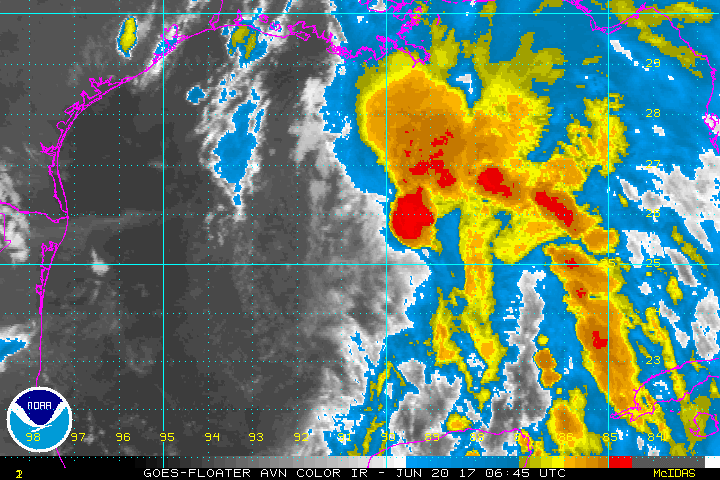
Deep convections appears to be forming on the northern side of the surface center with Potential Tropical Cyclone Three. If this can hold on and wrap around the center, we will have a tropical storm on our hands. Its name will be Cindy.
The NHC has extended the Tropical Storm Warning westward to High Island Texas. The Tropical Storm Watch now includes the Houston/Galveston area. 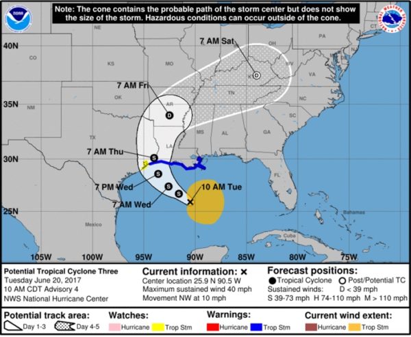
A buoy well north of the storm at Southwest Pass has winds East at 31 knots gusting to 38 knots. A buoy well to the west of the center has northerly winds at 23.3 knots gusting to 27 knots. A buoy to the has SSE winds at 23 knots gusting to 29 knots.
An Air Force Reserver Hurricane Hunter plane is expected to investigate the system later this morning.
The wind shear looks like it may be relaxing and if the system develops a well defined low level center, we will have Tropical Storm Cindy.
The main threat will be heavy rain and squally weather well away from the center all along the coast to the east as far as Northwest Florida. Tornado warning have been required for the eastern part of the Panhandle this morning including a tornado warning right now for Apalachicola.
Rip current threat will be extreme along the beaches of Alabama and Northwest Florida.
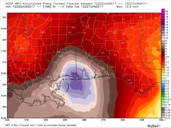
Look at these official rainfall forecast totals from WPC. That’s a 13.4 inch bulleye near Grand Bay, Alabama.
FAST FACTS
SUMMARY OF 1000 AM CDT…1500 UTC…INFORMATION
———————————————–
LOCATION…25.9N 90.5W
ABOUT 265 MI…430 KM S OF MORGAN CITY LOUISIANA
ABOUT 355 MI…565 KM SE OF GALVESTON TEXAS
MAXIMUM SUSTAINED WINDS…40 MPH…65 KM/H
PRESENT MOVEMENT…NW OR 320 DEGREES AT 10 MPH…17 KM/H
MINIMUM CENTRAL PRESSURE…999 MB…29.50 INCHES
Here is the rest of the advisory.
WATCHES AND WARNINGS
——————–
CHANGES WITH THIS ADVISORY:
The Tropical Storm Warning has been extended westward to High
Island, Texas.
A Tropical Storm Watch is in effect from west of High Island to San
Luis Pass, Texas.
SUMMARY OF WATCHES AND WARNINGS IN EFFECT:
A Tropical Storm Warning is in effect for…
* High Island to the Mouth of the Pearl River
A Tropical Storm Watch is in effect for…
* West of High Island to San Luis Pass
A Tropical Storm Warning means that tropical storm conditions are
expected somewhere within the warning area, in this case within the
next 24 to 36 hours.
A Tropical Storm Watch means that tropical storm conditions are
possible within the watch area, generally within 48 hours.
Interests elsewhere along the U.S. Gulf Coast from the central Texas
coast to the western Florida Panhandle should monitor the progress
of this system.
For storm information specific to your area, including possible
inland watches and warnings, please monitor products issued by your
local National Weather Service forecast office.
DISCUSSION AND 48-HOUR OUTLOOK
——————————
At 1000 AM CDT (1500 UTC), the disturbance was centered near
latitude 25.9 North, longitude 90.5 West. The system is moving
toward the northwest near 10 mph (17 km/h) and this motion is
expected to continue through Wednesday night. A turn toward the
north-northwest is forecast early Thursday. On the forecast track,
the disturbance is expected to be near the southwest Louisiana coast
late Wednesday or Wednesday night, and move inland over western
Louisiana and eastern Texas on Thursday.
Maximum sustained winds are near 40 mph (65 km/h) with higher gusts.
Some slight strengthening is possible before the system reaches the
coast.
Satellite imagery shows that the center of the disturbance is
gradually become better defined, and it is likely that the system
will become a tropical or subtropical cyclone later today.
* Formation chance through 48 hours…high…90 percent
* Formation chance through 5 days…high…90 percent
Tropical-storm-force winds extend outward up to 205 miles (335 km),
mainly to the north and east of the center.
The estimated minimum central pressure based on buoy data is 999 mb
(29.50 inches).
HAZARDS AFFECTING LAND
———————-
WIND: Tropical storm conditions are expected to first reach the
coast within the warning area later today and spread westward
within the warning area through Wednesday. Tropical storm
conditions are possible in the watch area on Wednesday.
RAINFALL: The disturbance is expected to produce total rain
accumulations of 6 to 9 inches with isolated maximum amounts of
12 inches over southeastern Louisiana, southern Mississippi,
southern Alabama, and the Florida Panhandle through Thursday.
Rainfall amounts of 3 to 5 inches with isolated maximum
amounts of 6 inches can be expected farther west across southwest
Louisiana into southeast Texas through Thursday.
STORM SURGE: Inundation of 1 to 3 feet above ground level
is possible along the coast in portions of the Tropical Storm
Warning area.
TORNADOES: A tornado or two is possible this afternoon and tonight
from south-central Louisiana to the western Florida Panhandle.
NEXT ADVISORY
————-
Next intermediate advisory at 100 PM CDT.
Next complete advisory at 400 PM CDT.
About the Author (Author Profile)
Bill Murray is the President of The Weather Factory. He is the site's official weather historian and a weekend forecaster. He also anchors the site's severe weather coverage. Bill Murray is the proud holder of National Weather Association Digital Seal #0001 @wxhistorianSubscribe
If you enjoyed this article, subscribe to receive more just like it.


