

A Complete Look at Cindy Including Central Alabama Expected Rainfall, Severe Weather
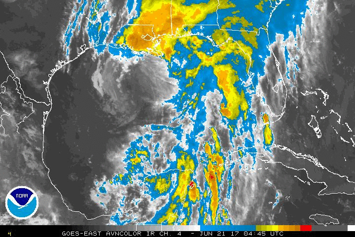
Cindy continues to produce life threatening flooding along the Gulf coast this morning.
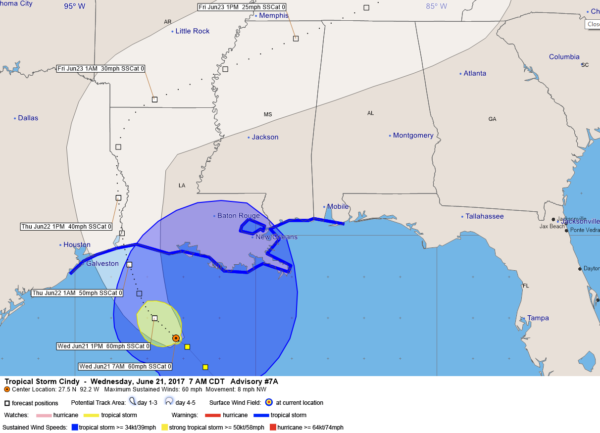
The storm strengthened overnight to 60 mph, where it is this morning. The latest central pressure was 996 mb, just slightly lower than last night when you went to bed.
The center of Cindy is now less than 180 miles south southeast of Cameron LA. Moving northwest at 8 mph, the center of Cindy should reach the coast between 3-6 a.m. tomorrow morning just west of Cameron.
Cameron is of course infamous for deadly Hurricane Audrey, which struck in exactly the same place nearly 60 years ago to the date, on June 27, 1957, killing 390 people and leaving 192 people never to be found.
7 AM CDT FAST FACTS
———————————————-
LOCATION…27.5N 92.2W
ABOUT 165 MI…265 KM SSW OF MORGAN CITY LOUISIANA
ABOUT 200 MI…325 KM SE OF GALVESTON TEXAS
MAXIMUM SUSTAINED WINDS…60 MPH…95 KM/H
PRESENT MOVEMENT…NW OR 310 DEGREES AT 8 MPH…13 KM/H
MINIMUM CENTRAL PRESSURE…996 MB…29.41 INCHES
Tropical storm warnings now extend from San Luis Pass, TX, west of Galveston to the Alabama/Florida border including New
Orleans and Lake Ponchartrain.
The wind field with Cindy has overspread the southeastern half of Louisiana, but there were no tropical storm force sustained winds or gusts at 7 a.m. across the state.
A few reports across the Gulf Coast:
New Orleans International…77F, Light rain/fog, wind NE 15, pressure 29.73
Boothville… Cloudy/Fog, 81F, SE 14 G 21, pressure 29.73
New Iberia…Cloudy, 72F, NE 15, Pressure 29.71
Patterson…Cloudy, 74F, NE 17 G 25, pressure 29.68
The strongest winds (58 mph or greater) extend out about 80 miles to the northwest of the center but Cindy is expected to weaken before landfall and should reach land with winds of 50 mph.
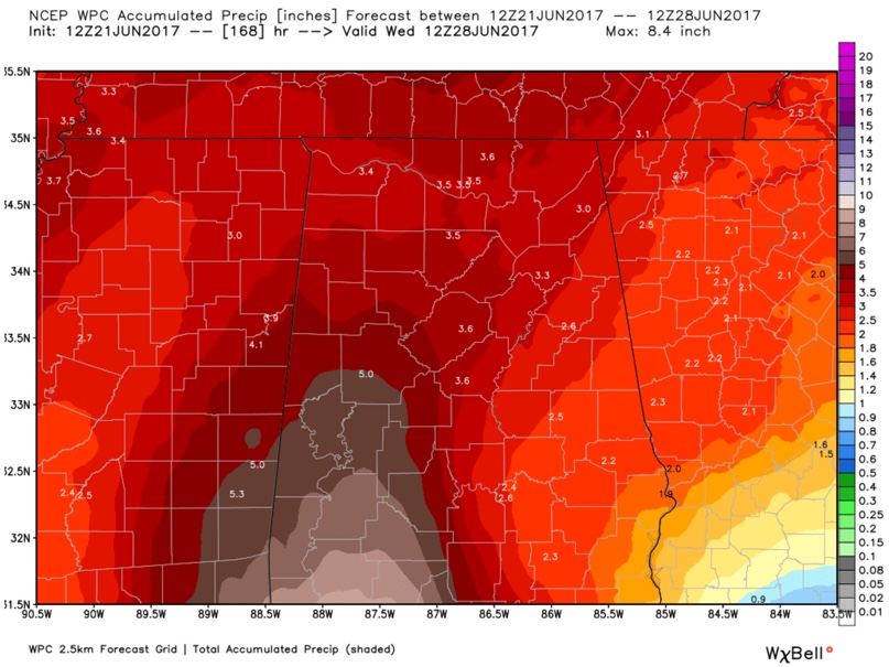
The heaviest rain is moving onshore all across the Florida Panhandle at this time with the rain taking a break along the Mississippi and Alabama Coasts. Flash flood warnings extend from the hattiesburg area through Mobile and Baldwin Counties in Alabama to the Fort Walton area. Rainfall totals will reach 6-9 inches in many spots with isolated amounts to 12 inches. Inland, 3-5 inch amounts will be common, including across Central Alabama.
The mass of rain now lifting across South Alabama and Northwest Florida will impact us here in Central Alabama today. Periods of rain are in the forecast through tonight and much of Thursday. Here is the expected rainfall across Central Alabama for the next seven days, with most of it coming today and Thursday, with the exception of about one inch on Saturday as a front moves through and clears us out.
Some current storm total rainfall reports:
Pensacola Beach: 6.11 inches
Gulfport: 7.19 inches (6.14 in last 12 hours)
Saucier MS: 5.48 inches
Mobile: 4:14 inches so far through 7 a.m .
The Park Service has closed Highway 399 between Navarre and Pensacola Beach due to flooding. Surge is expected to be 1-3 feet in the warning area with isolated 4 foot instances. On Dauphin Island, ankle deep water is reported at the corner of Highway 193 and Bienville Blvd.
A tornado watch remains in effect for Southeast Louisiana, coastal Mississippi, coastal Alabama and extreme Northwest Florida. Tornado damage was reported in Fort Walton around Monahan Drive around 6 a.m. Eglin Parkway was completely blocked by downed power lines. Tornado warnings are currently in effect for Hancock County MS and St. Tammany Parish in Louisiana which is just east of Slidell. Drier air which was entrained into the storm has enhanced the tornado threat with the stronger convection.
Severe weather will be a threat for us in Alabama, especially the northwestern portion of the area on Friday with a threat of tornadoes as the low recurves and tracks to our northwest. We will be monitoring that situation and keeping you updated.
Here is the complete text of the rest of the advisory:
WATCHES AND WARNINGS
——————–
CHANGES WITH THIS ADVISORY:
None.
SUMMARY OF WATCHES AND WARNINGS IN EFFECT:
A Tropical Storm Warning is in effect for…
* San Luis Pass Texas to the Alabama-Florida border
* Metropolitan New Orleans
* Lake Pontchartrain
A Tropical Storm Warning means that tropical storm conditions are
expected somewhere within the warning area, in this case within the
next 12 to 24 hours.
Interests elsewhere along the U.S. Gulf Coast from the central Texas
coast to the western Florida Panhandle should monitor the progress
of this system.
For storm information specific to your area, including possible
inland watches and warnings, please monitor products issued by your
local National Weather Service forecast office.
DISCUSSION AND 48-HOUR OUTLOOK
——————————
At 700 AM CDT (1200 UTC), the center of Tropical Storm Cindy was
located near latitude 27.5 North, longitude 92.2 West. Cindy is
moving toward the northwest near 8 mph (13 km/h), and this motion is
expected to continue today. A turn toward the north-northwest and
then toward the north is expected later today and early Thursday. On
the forecast track, the center of Cindy will approach the coast of
southwest Louisiana and southeast Texas late today or tonight, and
move inland over southeastern Texas or southwestern Louisiana on
Thursday.
Maximum sustained winds remain near 60 mph (95 km/h) with higher
gusts. Little change in strength is expected today. Slight
weakening is forecast to begin on Thursday.
Tropical-storm-force winds extend outward up to 275 miles (445 km),
mainly north through northeast of the center.
The minimum central pressure recently reported by an Air Force
Hurricane Hunter aircraft was 996 mb (29.41 inches).
HAZARDS AFFECTING LAND
———————-
RAINFALL: Cindy is expected to produce total rain accumulations of
6 to 9 inches with isolated maximum amounts of 12 inches over
southeastern Louisiana, southern Mississippi, southern Alabama, and
the Florida Panhandle through Thursday. This rainfall could cause
life-threatening flash flooding in these areas.
Rainfall amounts of 3 to 5 inches with isolated maximum amounts of 6
inches can be expected farther west across western Louisiana and
eastern Texas through Thursday. Rainfall should spread
northeastward across Arkansas and into portions of the Tennessee and
Ohio Valleys through Friday, with total rain accumulations of 3 to 5
inches with locally higher amounts possible.
WIND: Tropical storm conditions are affecting portions of the
northern Gulf of Mexico coast over the eastern part of the warning
area. These conditions should spread westward within the warning
area through early Thursday.
STORM SURGE: Inundation of 1 to 3 feet above ground level is
expected along the coast in portions of the Tropical Storm Warning
area, with isolated areas possibly up to 4 feet.
TORNADOES: A few tornadoes are possible this morning through
tonight from the western Florida Panhandle to southern Louisiana.
NEXT ADVISORY
————-
Next complete advisory at 1000 AM CDT.
About the Author (Author Profile)
Bill Murray is the President of The Weather Factory. He is the site's official weather historian and a weekend forecaster. He also anchors the site's severe weather coverage. Bill Murray is the proud holder of National Weather Association Digital Seal #0001 @wxhistorianSubscribe
If you enjoyed this article, subscribe to receive more just like it.


