

Flooding Threat Continues; Isolated Tornadoes
**No afternoon Weather Xtreme video due to ongoing severe weather in far South Alabama**
DANGEROUS STORMS OVER SOUTH ALABAMA: As I write this at 2:50p CT a dangerous storm with a possible was approaching Foley in southern Baldwin County…
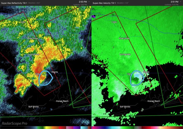
Photo below is from @coachjay37

A tornado watch is in effect for much of the Central Gulf coast, and will continue tonight.
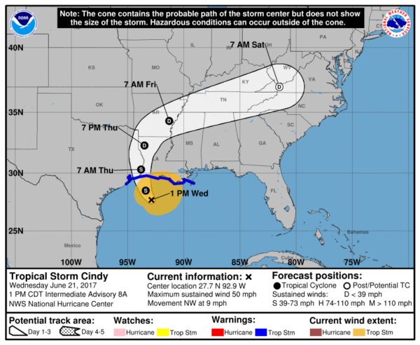
LATEST ON TS CINDY: Cindy is packing sustained winds of 50 mph, and will make landfall near the Sabine Pass (Texas/Louisiana border) after midnight tonight. Do not focus on the storm center; the main impact will be up to 600 miles east of the lowest pressure.
IMPACT FOR NORTH/CENTRAL ALABAMA: A soaking rain continues at times through tomorrow; showers and storms will be a bit more scattered in nature Friday, but still occasionally numerous. A flash flood watch remains in effect for the Birmingham metro and points south and west; additional rain of 2-4 inches is expected.
Cells tomorrow and Friday will also be capable of producing a few short lived tornadoes. It is important to note that these often last for only a few minutes, and due to the low topped nature of the convection thy are often “under the radar” and no warning can be provided. Pay very close attention to the weather on both days and pay attention to warnings.
Bottom line, flooding is possible statewide tomorrow and possibly into Friday. And, isolated tornadoes are possible statewide tomorrow and Friday.
The weather will remain unsettled Saturday with scattered to numerous thunderstorms, but they thin out greatly by Sunday as drier air begins to creep into North Alabama. Much of next week looks rain-free as unusually dry air for June settles into the Deep South.
IMPACT ON THE GULF COAST: NWS Mobile continues to emphasis this flood threat for the Central Gulf Coast is “extreme” and “life threatening”…
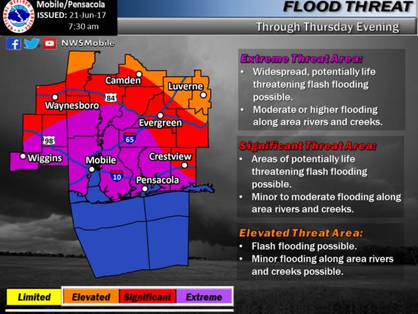
Flooding is likely on the coast through tomorrow, with a lesser threat Friday as Cindy weakens and lifts away from the region. Some communities have received over six inches of rain, and another 4-6 inches is expected over the next 36 hours.
Waterspouts and tornadoes remain possible on the coast tonight and tomorrow. Pay very close attention to flash flood and tornado warnings as they are issued.
Showers and storms become more scattered Friday on the coast, and the weekend will feature some fairly typical summer weather with a mix of sun and scattered thunderstorms. Next week looks pretty routine as well.
We will keep the blog updated with fresh information through the next few days, check it often.
WEATHER BRAINS: Don’t forget you can listen to our weekly 90 minute netcast anytime on the web, or on iTunes. This is the show all about weather featuring many familiar voices, including our meteorologists here at ABC 33/40.
CONNECT: You can find me on all of the major social networks…
Facebook
Twitter
Google Plus
Instagram
Pinterest
Snapchat: spannwx
Look for the next Weather Xtreme video here by 7:00 a.m. tomorrow…
Category: Alabama's Weather, ALL POSTS
About the Author (Author Profile)
James Spann is one of the most recognized and trusted television meteorologists in the industry. He holds the AMS CCM designation and television seals from the AMS and NWA. He is a past winner of the Broadcast Meteorologist of the Year from both professional organizations.Subscribe
If you enjoyed this article, subscribe to receive more just like it.


