

Feeder Band Lifting North With Heavy Rain, Some Strong Storms
The outer feeder band of Tropical Storm Cindy is spreading north across West Central and South Central Alabama tonight. We have been tracking this impressive feeder band since it developed this afternoon over the Gulf, bringing a flow of deep tropical moisture northward.
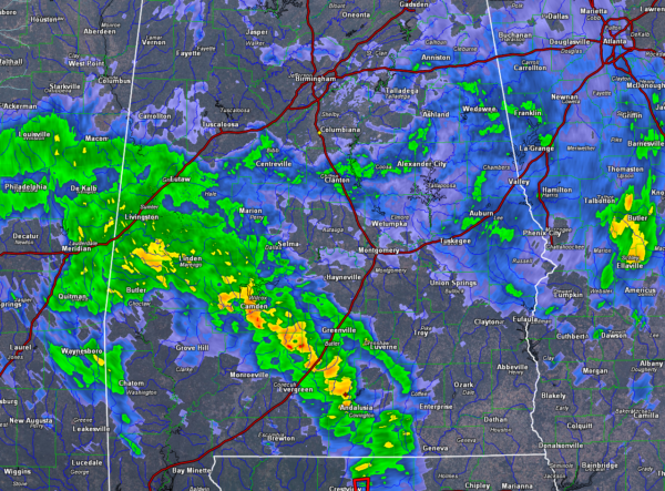
The arc of storms extends from Butler in Choctaw County to Camden in Wilcox County to Andalusia in Covington County and south into the Florida Panhandle. The band is moving north at 35 mph. It will reach Montgomery around 11:15 p.m. It should reach Birmingham by 1 a.m. or so.
Rainfall rates are around a quarter of an inch of rain per hour for the most part, although the heavier cells are putting down between 0.5 and 1 inch per hour.
There is very little lightning, with current lightning limited to the cells moving into Butler and Wilcox Counties.
There is a decent amount of 0-1 km helicity associated with the feeder band, so any low topped supercells that get their act together could produce small spin up tornadoes.
There are also decent winds in the lower atmosphere associated with the band, and strong wind gusts are possible.
By the time the band gets to Montgomery, instability values will lessen and the threat will diminish.
There was a tornado warning a short time ago in Covington County, but that cell has weakened.
A tornado watch covers the area from Washington, Clarke, Monroe, Conecuh, Covington and Geneva Counties southward.
Category: Alabama's Weather, ALL POSTS
About the Author (Author Profile)
Bill Murray is the President of The Weather Factory. He is the site's official weather historian and a weekend forecaster. He also anchors the site's severe weather coverage. Bill Murray is the proud holder of National Weather Association Digital Seal #0001 @wxhistorianSubscribe
If you enjoyed this article, subscribe to receive more just like it.


