

10:45 AM: Areal Flood Advisories Posted Across Central Alabama
In addition to the new Areal Flood Warning that is now in effect for parts of Autauga and Lowndes Counties, the National Weather Service in Birmingham maintains Flood Advisories for parts of Greene, Hale, Marengo, Pickens, Sumter, Bibb, Perry and Tuscaloosa Counties.
Minor flooding is likely in the flood advisory area.
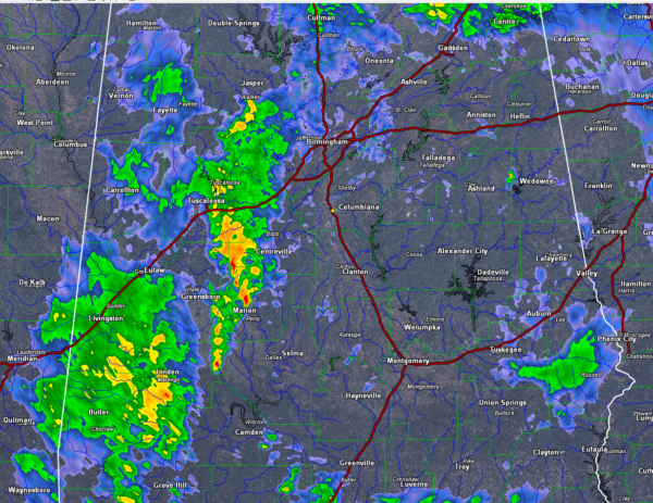
At this hour, the feeder band that brought 1-2 inches of rain to much of the area overnight has pushed into Northeast Alabama and weakened. Moderate rain still cover parts of Jackson, DeKalb, Etowah and Cherokee Counties.
A second feeder band is set up from southern Walker and western Jefferson counties through Tuscaloosa, Bib and Perry Counties into Marengo and Clarke County. The heavier cells are putting down between one half and one inch per hour with the heaviest putting down over an inch per hour.
Areas between Tuscaloosa and Birmingham will receive some of the heaviest rain over the next 90 minutes. The activity south of I-59 in West Alabama will impact much of Pickens, Tuscaloosa, Sumter, Greene and Hale Counties through noon.
No severe weather at this time and nothing that looks especially threatening. No lightning showing up on lightning detection networks at this time.
A tornado watch does continue for Southwest Alabama until 1 p.m. That likely will be extended into the evening hours as the severe weather threat will continue.
Category: Archived Warnings
About the Author (Author Profile)
Bill Murray is the President of The Weather Factory. He is the site's official weather historian and a weekend forecaster. He also anchors the site's severe weather coverage. Bill Murray is the proud holder of National Weather Association Digital Seal #0001 @wxhistorianSubscribe
If you enjoyed this article, subscribe to receive more just like it.


