

Drier Air Arriving This Afternoon
The cold front that assisted the development of a weak line of showers with embedded thunderstorms had reached South Alabama and while dew points had dropped some at the surface, a good deal of moisture remained in the mid and upper levels, so much of the state of Alabama was covered in clouds. Some patches of light rain and sprinkles were moving across the Tennessee River Valley at this writing, so some light rain is possible through the morning hours. But the dew points in Southeast Missouri and western Kentucky were in the 50s and that drier air should be arriving this afternoon. With clouds holding tough, we will see some peeks at the sun with highs in the lower and middle 80s.
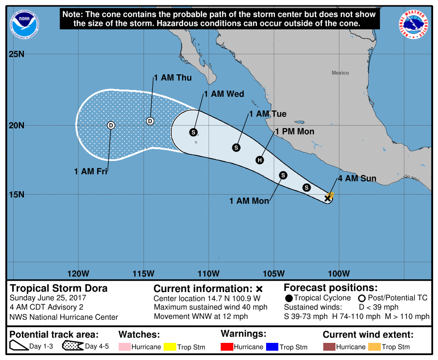
The tropical Atlantic is free of any areas of concern for now, and Tropical Storm Dora has formed in the Eastern North Pacific. Conditions appear favorable for additional intensification, so Dora is likely to become a hurricane on Monday. The track parallels and remains just offshore from the Mexican coast until Dora turns westward Wednesday and dissipates over the open water.
Monday, Tuesday, and Wednesday should be very nice days with plenty of sunshine as the surface high migrates eastward across the southern Appalachians. The upper air pattern remains somewhat flat with traveling system pushed north along the US-Canadian border. You can expect to see only a few passing clouds from time to time and temperatures slightly below what we expect for late June with lows in the 60s and highs in the middle 80s to upper 80s by Wednesday.
By Thursday and into the end of the week, the upper ridge begins to assert itself becoming very prominent by Sunday. At the surface, the high will migrate into the Atlantic which will turn the surface wind around to the south. This signals the end to those drier dew points as levels rise fairly quickly into the middle and upper 60s. While there is a distinct absence of any real upper air feature other than the ridge, it means we get back into a regime with those daily shower chances driven by the heat of the afternoon with the probability of showers around 30 to 40 percent.
The weather at the beach will remain unsettled this weekend but all the flash flood watches have been cancelled. The pattern should be settling into one that involves daily chances for a passing afternoon shower Monday and into the week ahead. Highs are expected to be in the middle 80s. Click here to see the AlabamaWx Beach Forecast Center page. The Beach Forecast is partially underwritten by the support of Brett/Robinson Vacation Rentals in Gulf Shores and Orange Beach. Click here to see Brett/Robinson’s Own Your Summer specials now!
Looking out into voodoo country, the GFS is bullish on the upper ridge extending from New Mexico to the Carolinas. This spells a bit of heat for the eastern two thirds of the country. The ridge maintains its prominence through the 7th of July, but the GFS promises some relief from the heat by the 10th of July with a strong trough digging into the eastern Great Lakes area helping to dampen the ridge over the eastern US.
James Spann will be back with the next edition of the Weather Xtreme Video first thing on Monday morning. Keep the umbrella handy for one last surge of light rain and then be ready to enjoy some lower humidity for several days. Godspeed.
-Brian-
Category: Alabama's Weather, ALL POSTS
About the Author (Author Profile)
Brian Peters is one of the television meteorologists at ABC3340 in Birmingham and a retired NWS Warning Coordination Meteorologist. He handles the weekend Weather Xtreme Videos and forecast discussion and is the Webmaster for the popular WeatherBrains podcast.Subscribe
If you enjoyed this article, subscribe to receive more just like it.


