

Weather Remains Unsettled
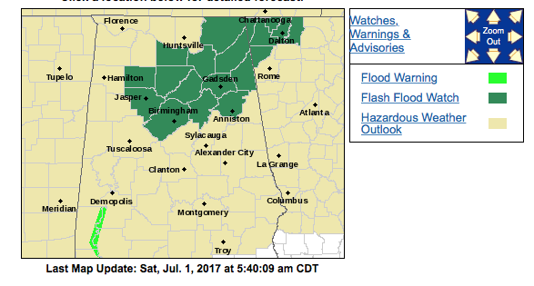
Nothing like starting out the early morning with a few thunderstorms, though those have dissipated. We also have a flash flood watch in effect from Birmingham northeastward into the northwest corner of Georgia valid until 7 pm this evening. Heavy rainfall over the past few days have resulted in a very saturated ground. Any prolonged period of heavy rain may result in localized flash flooding across this area this afternoon.
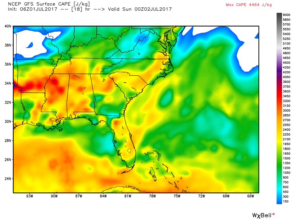
In addition to this SPC has much of Central Alabama in the standard slight risk for severe thunderstorms today. We continue to be in a very moisture-rich air mass with precipitable water values run 1.6 to 1.8 inches. This air mass should destabilize quickly with late morning and early afternoon heating resulting in CAPE values from 2500 to 3000 J/kg as highs climb into the upper 80s. We also have a couple of boundaries to deal with. One is the weak frontal boundary stretching from the eastern Great Lakes into northern Arkansas and the other the large cluster of thunderstorms that moved across southern Arkansas last night and early this morning. The result will be an unstable air mass with the potential for producing strong to severe thunderstorms capable of generating damaging wind. Take any severe thunderstorm warnings your hear seriously. The overall threat should diminish as the sun sets this evening and we lose the afternoon heating.
Unfortunately the air mass is not likely to change for us for the foreseeable future. This means that our overall weather pattern remains somewhat unsettled with daily chances for thunderstorms. The overall upper air pattern is forecast to remain with a trough over the eastern US and an upper ridge over the Rockies. A strong short wave moving across the northern tier of the US will help to reinforce that troughiness on Thursday, Friday, and Saturday. This means that we stay out of any excessive heat and stay at or just slightly below seasonal temperature averages. The western US will not be so luck as a very large upper ridge is forecast to build northward into Canada. This large ridge is likely to play a role in our weather for Week 2.
With no air mass change, a continuation of a moisture-rich air mass, and daily heating with highs in the range of the upper 80s to lower 90s, we’ll have to mention scattered showers each day. I sometimes feel that we’re playing the old whack-a-mole game trying to specify rain chances each day with variations of 10 or 20 percent. The bottom line is that there will be showers and storms everyday, coverage will change from day-to-day, everyone won’t get a shower everyday,and we have very little skill in telling you that one day will be 30 percent and another day will be 40 percent.
The weather at the beach will feature the possibility of a passing shower just about everyday for the next week with highs in the upper 80s. There is no indication of any all day rain situation, so you should be able to enjoy the beach with only short interruptions for a passing shower. Please heed those showers and don’t become a lightning statistic. Click here to see the AlabamaWx Beach Forecast Center page. The Beach Forecast is partially underwritten by the support of Brett/Robinson Vacation Rentals in Gulf Shores and Orange Beach. Click here to see Brett/Robinson’s Own Your Summer specials now!
There is very bad news for voodoo country. June was a relatively cool month, and July is starting off on about average, but the GFS is bullish on changing that pattern. By Tuesday July 11th, the big upper ridge has begun migrating east with a center over the Dakotas. By July 14th, the big ridge covers nearly all of the US except the extreme northwest corner and New England. By July 16th the ridge is much weaker, but it is centered over the Tennessee and Ohio River Valleys. So the present GFS is suggesting hot weather for us from July 12th to the 16th.
I expect to have the next Weather Xtreme Video posted here by 7 am or so on Sunday morning. Check back often for notes on what’s happening in Central Alabama weather. Enjoy your day, stay safe should you be impacted by thunderstorms. Godspeed.
-Brian-
Category: Alabama's Weather, ALL POSTS
About the Author (Author Profile)
Brian Peters is one of the television meteorologists at ABC3340 in Birmingham and a retired NWS Warning Coordination Meteorologist. He handles the weekend Weather Xtreme Videos and forecast discussion and is the Webmaster for the popular WeatherBrains podcast.Subscribe
If you enjoyed this article, subscribe to receive more just like it.


