

Shower, Showers, Showers
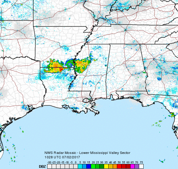
Another interesting (read that as challenging) forecast today with yet another MCS moving steadily across southern Arkansas this morning. Add to that feature all the leftover boundaries from yesterdays storms, the moisture-rich air in place across Alabama as evidenced by dew points around 70, and afternoon heating, and you have an excellent recipe for afternoon and early evening showers and thunderstorms. Storms today are not expected to be severe though the threat is not completely zero. The guys at WPC continue to show a marginal risk for heavy rainfall across the northern half of Alabama, and that seems very reasonable given the relatively slow movement of storms and the extremely wet soil conditions in place. Highs today are expected to be in the upper 80s. Birmingham actually hit 91 yesterday before the storms dropped temperatures about 12 degrees.
A weak disturbance in the 500 millibar flow this morning appears to be associated with the thunderstorm complex moving across southern Arkansas, so we’ll have to keep an eye on that feature to see if it does hold together. An animation of the regional radar imagery shows it to be plodding steadily eastward along and just north of the I-20 corridor in Louisiana and Mississippi.
The Atlantic and Eastern North Pacific have sprouted a couple of areas of concern. There is one in the Atlantic west-southwest of the Cabo Verde Islands and there are two areas of disturbed weather just offshore of the Mexican Coast. All three areas are forecast to slowly strengthen over the next 5 days as the move westward.
There is little change to the overall upper air pattern for the week ahead from what we saw yesterday. The weak troughiness remains in place across the eastern US, and that troughiness is reinforced starting Wednesday by a strong short wave digging into the Middle Mississippi River Valley. The feature moves into the Ohio River Valley on Thursday and into the Mid-Atlantic states on Friday. At the surface this drags a cold front into the Southeast US. It’s interesting to note that neither the GFS nor the ECMWF seem to actually do much with the feature in the way of increasing clouds and showers. GFS MOS guidance numbers keep rain chances around 30 percent. If this feature does come about, I would expect the chances for rain to go up a good deal in response to a feature that should enhance showers since the air mass stays very juicy. We’ll just have to wait and see.
Temperatures for the week ahead will be pretty steady. You can expect to see highs in the range from the upper 80s to lower 90s with lows sticking pretty close to the 70-degree mark.

The weather at the beach will feature the possibility of a passing shower just about everyday for the next week with highs in the upper 80s. There is no indication of any all day rain situation, so you should be able to enjoy the beach with only short interruptions for a passing shower. Please heed those showers and don’t become a lightning statistic. Click here to see the AlabamaWx Beach Forecast Center page. The Beach Forecast is partially underwritten by the support of Brett/Robinson Vacation Rentals in Gulf Shores and Orange Beach. Click here to see Brett/Robinson’s Own Your Summer specials now!
Yesterday I highlighted voodoo country as presenting bad news with the heat ridge building strongly into the eastern portion of the US. So guess what the GFS is showing this morning? Yup, NO HEAT RIDGE! I’ll give a loud woohoo for that. Oh, wait, does that mean it could come back tomorrow? Okay, we know the story in voodoo country. But the run this morning is very different. It starts out similar to yesterday with a northward bulging ridge over the eastern slopes of the Rockies around July 11th. But a strong upper low in southern Canada around the 14th of July keeps the big ridge over the western states. And the GFS pushes the ridge further west with a short wave digging into the Central US around the 17th. I like this pattern a whole lot more than the one we saw yesterday because this one means NO excessive heat for us. But this could all change with the run tomorrow. Such is life in voodoo country.
James Spann has left the building, so I’ll have the next Weather Xtreme Video on Monday morning. While he is vacationing, we’ll have the morning video only. Enjoy the day, keep an umbrella handy, and Godspeed.
-Brian-
Category: Alabama's Weather, ALL POSTS
About the Author (Author Profile)
Brian Peters is one of the television meteorologists at ABC3340 in Birmingham and a retired NWS Warning Coordination Meteorologist. He handles the weekend Weather Xtreme Videos and forecast discussion and is the Webmaster for the popular WeatherBrains podcast.Subscribe
If you enjoyed this article, subscribe to receive more just like it.


