

Severe Thunderstorm Warning Continues For Parts Of Dekalb County Until 4:00PM

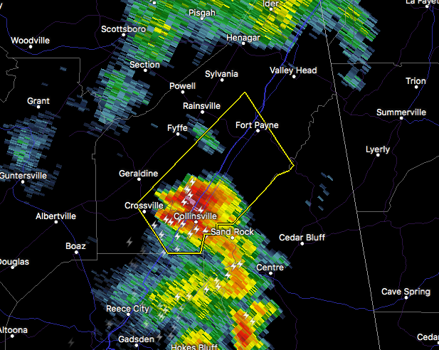
…A SEVERE THUNDERSTORM WARNING REMAINS IN EFFECT UNTIL 400 PM CDT FOR SOUTHEASTERN DEKALB COUNTY… At 341 PM CDT, a severe thunderstorm was located near Collinsville, or 8 miles southwest of Fort Payne, moving northeast at 25 mph.
HAZARD…60 mph wind gusts.
SOURCE…Radar indicated.
IMPACT…Expect damage to roofs, siding, and trees. Locations impacted include… Fort Payne, Rainsville, Little River Canyon National Preserve, Collinsville, Pine Ridge, Collbran, Dog Town, Little River Canyon Np, Lebanon and Adamsburg.
Severe Thunderstorm Warning Issued For Parts Of Dekalb County Until 4:00PM
Jul 5th @ 3:30 pm

The National Weather Service in Huntsville Alabama has issued a
* Severe Thunderstorm Warning for…
Southeastern DeKalb County in northeastern Alabama…
* Until 400 PM CDT
* At 329 PM CDT, a severe thunderstorm was located over Collinsville, or 13 miles southwest of Fort Payne, moving northeast at 25 mph.
HAZARD…60 mph wind gusts.
SOURCE…Radar indicated.
IMPACT…Expect damage to roofs, siding, and trees.
* Locations impacted include…
Fort Payne, Rainsville, Little River Canyon National Preserve, Collinsville, Crossville, Pine Ridge, Collbran, Dog Town, Little
River Canyon Np and Skirum.
Category: Archived Warnings
About the Author (Author Profile)
Subscribe
If you enjoyed this article, subscribe to receive more just like it.


