

Showers and Storms Forming Over Northwest Alabama
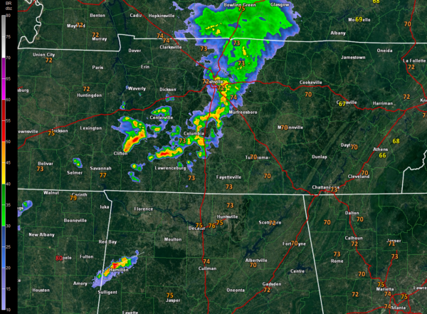
A strong upper level disturbance moving through Middle Tennessee triggered strong storms this evening that prompted severe thunderstorm and even tornado warnings.
The storms near the comma head of the disturbance have weakened, but new storms have formed along the southern flank of the vortex.
Surprisingly, storms have formed rapidly over Marion County in Alabama. Tops northwest of Hamilton are already over 40,000 feet.
These storms are in an axis of instability that should diminish as we go through time. But the storms may hold together through the overnight hours.
More showers and storms will form across North and Central Alabama on Thursday. Some of them could be strong again with a couple approaching severe limits. Damaging winds will be the main threat.
Category: Alabama's Weather, ALL POSTS
About the Author (Author Profile)
Bill Murray is the President of The Weather Factory. He is the site's official weather historian and a weekend forecaster. He also anchors the site's severe weather coverage. Bill Murray is the proud holder of National Weather Association Digital Seal #0001 @wxhistorianSubscribe
If you enjoyed this article, subscribe to receive more just like it.


