

Northeastern Jefferson County: Be Alert for Strong Winds
UPDATE 240 PM
Storms have intensified just west of Tuscaloosa. They are moving into the main part of Tuscaloosa now.
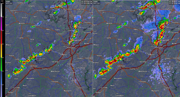
A corridor of showers and storms is marching eastward across North and Central Alabama at this hour. The strongest storms are in the Huntsville area at 2:20 with other strong storms in northwestern Cullman County, southern Cullman and western Blount into northern Jefferson County, and over northern Tuscaloosa County moving into western Jefferson County.
Storms are currently affecting northern parts of the Birmingham Metro from Gardendale to just west of Fultondale to near Adamsville. They will affect areas from Center Point and Pinson to Clay, Trussville and Argo. These storms have the potential to produce downburst winds. Areas from the Tarrant and the Birmingham Airport north should be alert.
Trees will come down with 40-50 mph winds because of the saturated ground, easily possible with any downbursts that occur.
The storms across northern Tuscaloosa into western Jefferson counties will miss the main part of the City of Tuscaloosa, but thunder will be heard. Northport will definitely get a glancing blow from them. The cell north of Northport is really getting its act together and could be formidable when it gets to southwestern Jefferson County.
These storms will impact the Greater Birmingham area from downtown southward between 3 and 4 p.m.
Heavy rain and lightning will be the main impacts, but there could also be damaging winds as these storms collapse eventually.
About the Author (Author Profile)
Bill Murray is the President of The Weather Factory. He is the site's official weather historian and a weekend forecaster. He also anchors the site's severe weather coverage. Bill Murray is the proud holder of National Weather Association Digital Seal #0001 @wxhistorianSubscribe
If you enjoyed this article, subscribe to receive more just like it.


