

Showers Numerous Today; Less by Sunday
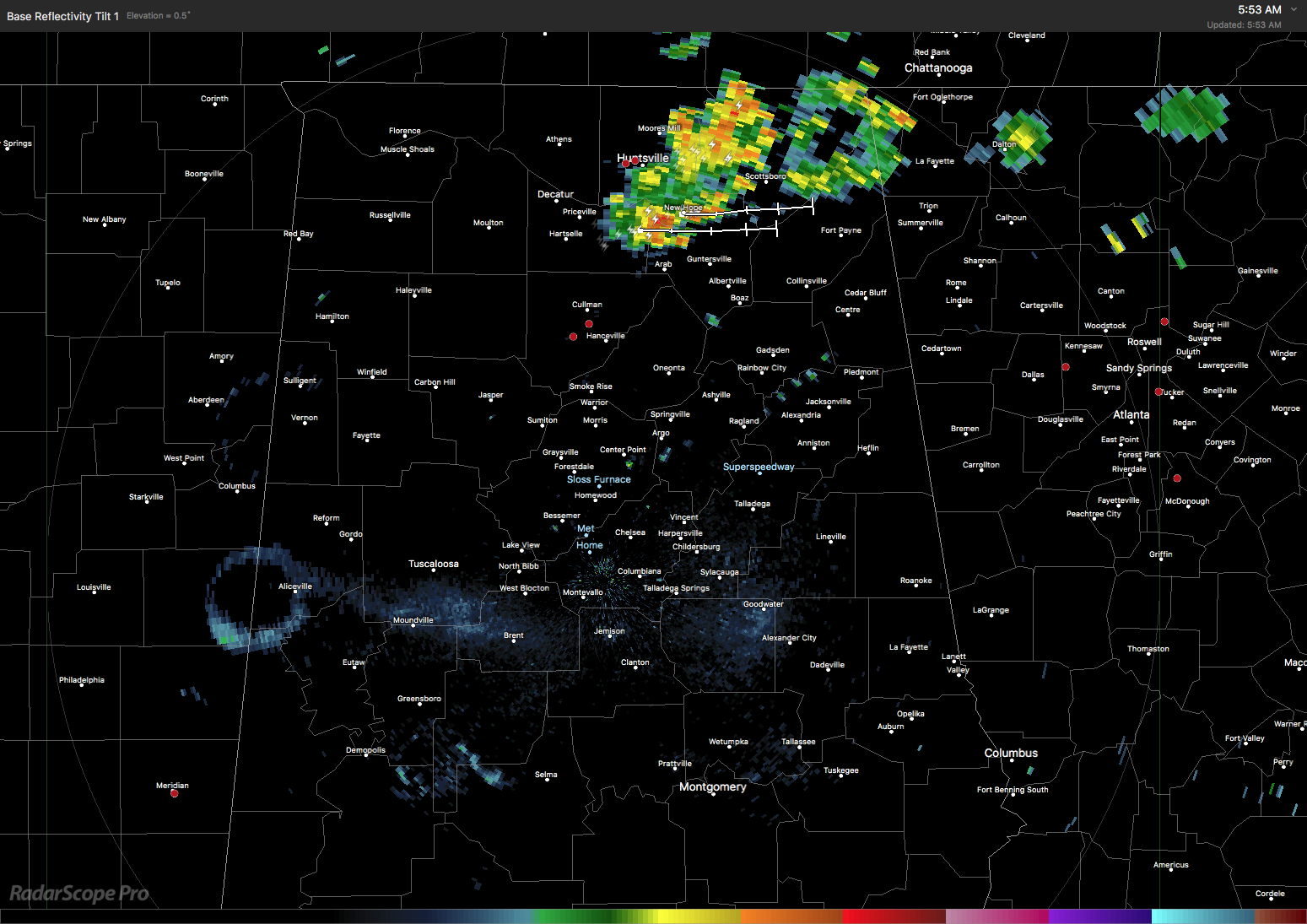
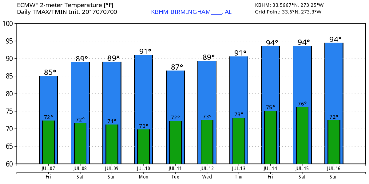
It seems like the radar and satellite images for the last several days have all been similar in appearance as I start the video preparation. Once again this morning we have clouds and showers across the Tennessee River Valley, mainly the eastern half. Temperatures are starting out again in the 70s and with slightly more clouds and showers becoming a tad more numerous, we should see highs confined primarily to the upper 80s. Spots that stay shower free well into the afternoon could reach the lower 90s again. While not mentioned in the SPC outlook, I think there remains a risk for isolated severe storms this afternoon as CAPE value surge to around 3000 J/kg across Central Alabama.
The trough axis swings through the Southeast US today and tonight reaching closer to the Gulf Coast by Saturday afternoon. Showers will occur primarily across South Alabama on Saturday, but shower chances will stick around North and Central Alabama as precipitable water values stay fairly high.
Sunday and Monday the GFS is showing precipitable water values dropping below 1.2 inches for the northern half of Alabama, so I think we can drop the mention of showers for those two days, but we’ll have to keep them in the forecast for South Alabama. Both of these days the GFS MOS guidance drops dew points into the mid 60s. While not nearly as nice as mid 50s, these values should be noticeable and make the highs of 89 to 93 feel not quite as hot.

The upper trough begins to pull north of us Tuesday with weak upper ridging in place by Wednesday and holding into Thursday. These look like they could be some of the warmest days of the summer with highs in the lower and middle 90s. I note here that the GFS MOS does not agree with this thinking keeping highs around 90. I think the upper air pattern supports higher temperatures with thickness values some of the highest we see for the next 7 days.
A strong short wave moving across Canada on Friday will dig into the eastern US once again strengthening the trough and pushing the upper ridge back to the west. This keeps us out of excessive heat with highs in the range from the upper 80s to lower 90s. Unfortunately moisture levels comes back up so showers return to the forecast Wednesday and stay a possibility through the end of the week.
The weather at the beach will include the possibility of passing showers just about everyday for the next 7 days with highs in the upper 80s. There is no indication of any all day rain situation, so you should be able to enjoy the beach with only short interruptions for a passing shower. Please heed those showers and don’t become a lightning statistic. Rip current threat is low for the next couple of days. Click here to see the AlabamaWx Beach Forecast Center page. The Beach Forecast is partially underwritten by the support of Brett/Robinson Vacation Rentals in Gulf Shores and Orange Beach. Click here to see Brett/Robinson’s Own Your Summer specials now!
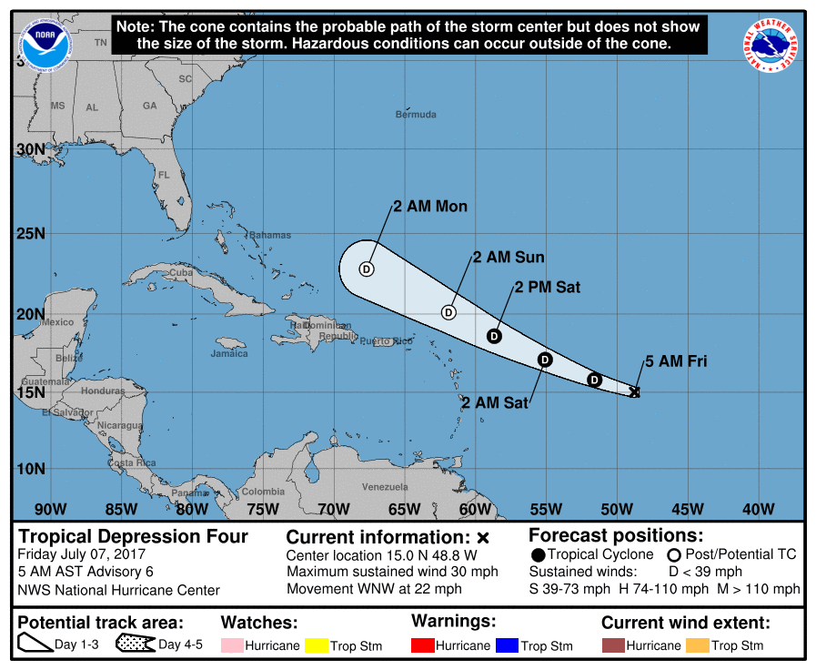
In the tropical Atlantic we are still focused on Tropical Depression Four. It is still struggling and likely to remain a depression before dissipating late Sunday or early Monday. The eastern North Pacific is a little quieter, too, with just one area of real concern. And that area will remain well out to sea away from the Mexican coast.
The GFS remains my good summertime friend as it continued on this run to keep a trough over the eastern third of the US and the strong upper ridge over the Rockies. This pattern promotes near average temperatures for the eastern half of the country. The GFS has also presented with a little tropical mischief across the Caribbean and Southwest Gulf. The continuity of the trough over the eastern US is certainly good news to all the people living east of the Rockies, but the heat for the western states just does not seem to want to let go.
I plan to have the next Weather Xtreme Video posted here by 7 am or so on Saturday morning. Look for additional details on Alabama’s weather by checking back frequently. Have a great day and Godspeed.
-Brian-
Category: Alabama's Weather, ALL POSTS
About the Author (Author Profile)
Brian Peters is one of the television meteorologists at ABC3340 in Birmingham and a retired NWS Warning Coordination Meteorologist. He handles the weekend Weather Xtreme Videos and forecast discussion and is the Webmaster for the popular WeatherBrains podcast.Subscribe
If you enjoyed this article, subscribe to receive more just like it.


