

A Quick Look At Our Saturday Weather Situation At 11:20AM
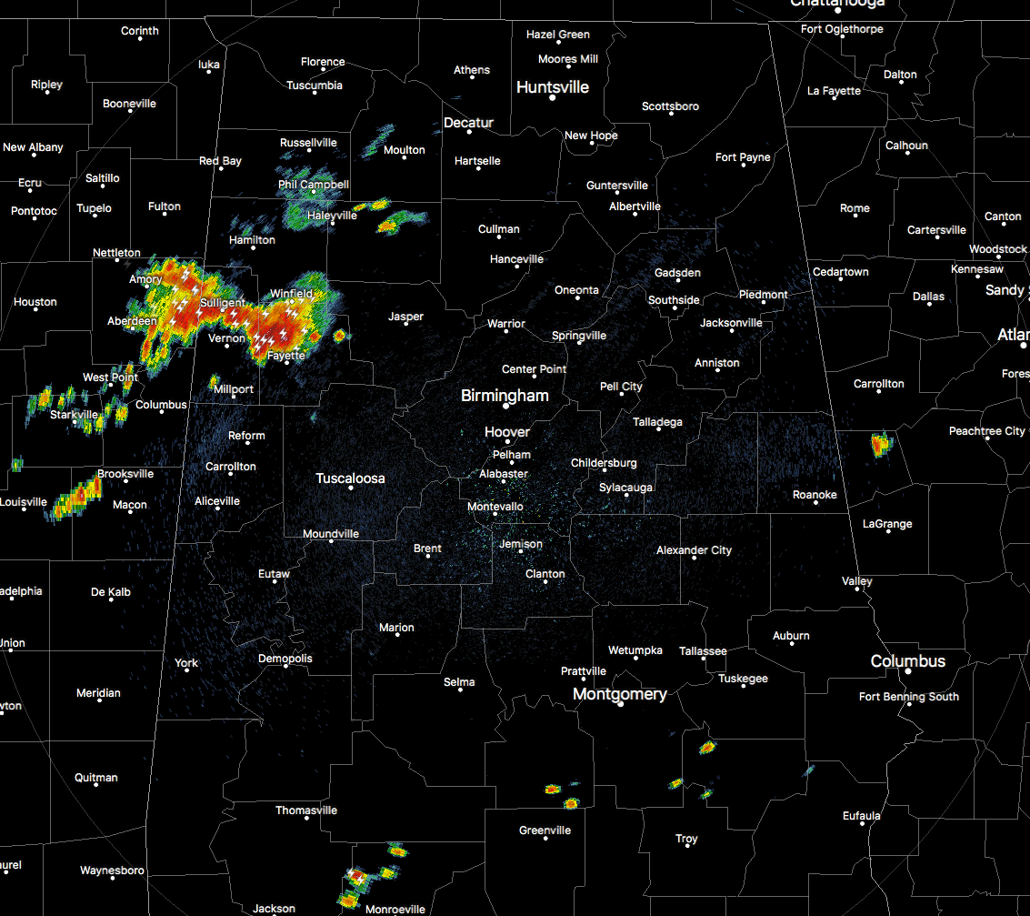
Radar Check at 11:05AM
Much of the north and central parts of Alabama are free from shower and storm activity at this point, but what will grab your attention is the big thunderstorms that are rolling through Lamar and Fayette counties. These storms are producing torrential amounts of rainfall, plenty of dangerous cloud-to-ground lightning, and gusty winds in excess of 40 MPH. All of these were moving southeastward at around 20 MPH, and will be affecting Vernon, Sulligent, Beaverton, Crews, Bedford, star, Pine Springs, and the Lamar County Airport and Public Lake.
There are a few smaller showers that have popped up within the last few minutes over the extreme southern portion of the area, but these are small at this point and do not have any lightning with them. I’m sure that will change shortly.
Severe Weather Threat For Today
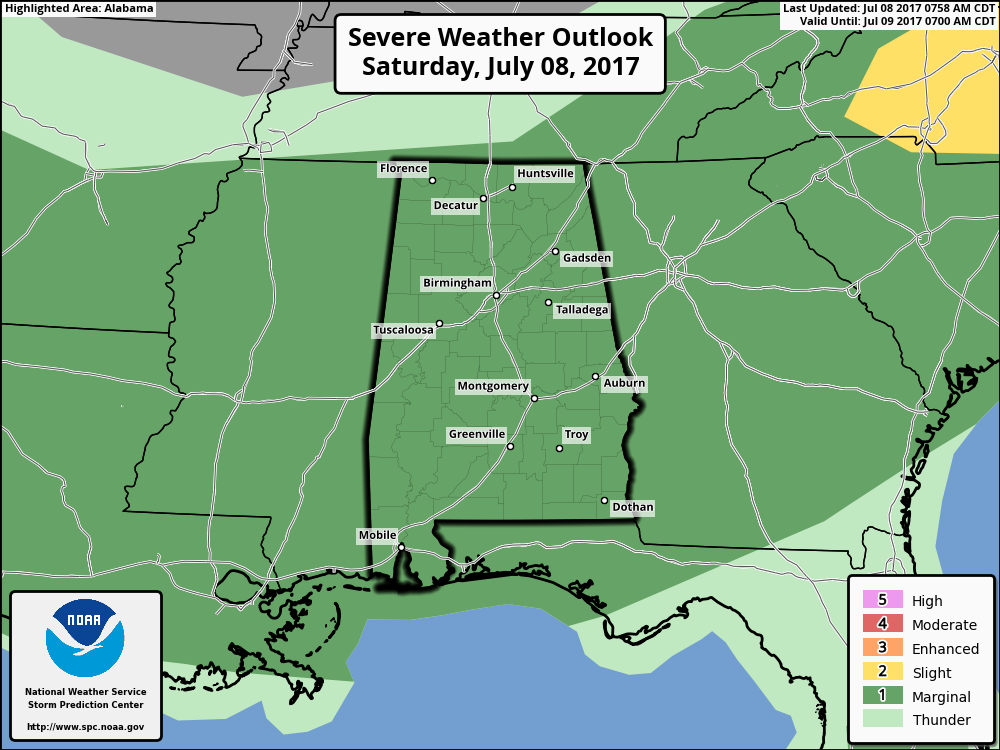
As you can see by the latest Severe Weather Outlook image from the Storm Prediction Center out in Norman, Oklahoma, the entire state of Alabama is defined in a Marginal Risk for severe weather throughout the entire day today. The main risk will be from damaging downburst thunderstorm winds, and there may be some small hail as well, but that will be rare in today’s storms.
Surface instability values are already showing up in near 3500 J/kg over the northwestern parts of Central Alabama, and this is where that strong storm activity has already fired up. Downdraft CAPE values are already approaching 1100 J/kg, so high downdraft winds will definitely be possible in stronger storms today.
Convective temperature on the last Birmingham sounding is only 85 degrees. Shower and storm development will really start to take off across the area when we reach and surpass that mark.
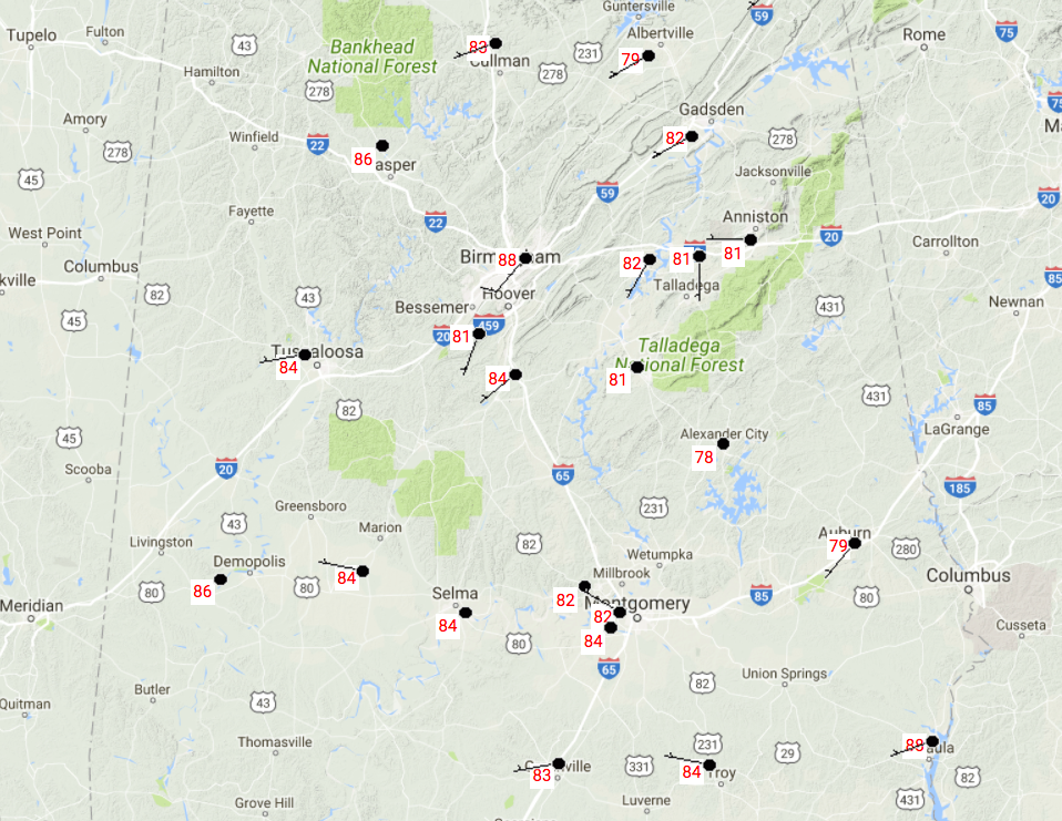
Temperatures At 10:55AM
Most everyone in the Central Alabama area are already well up into the 80s at this point, with Birmingham and Eufaula at 88 degrees. Alexander City is the current cool spot at 78 degrees.
So Here Is What To Expect For Today
Showers and thunderstorms will continue to develop and grow stronger as we end the morning and move into the afternoon. Neither one of the high resolution models are picking up on the activity that has already fired up, but both do have plenty of scattered storms developing as go through the day. When it is not raining at your location, you can expect a mix of sun and clouds with highs making it into the upper 80s to the lower 90s throughout the area. The main window for stronger to severe storms will be from 12:00PM-8:00PM as we’ll have the heating of the day helping out with development. Storms will start to dissipate area-wide until about 10:00PM, but a few storms will linger in the southern parts of the area near the cold front. Overnight lows will be in the upper 60s to the lower 70s.
Category: Alabama's Weather, ALL POSTS
About the Author (Author Profile)
Scott Martin is an operational meteorologist, professional graphic artist, musician, husband, and father. Not only is Scott a member of the National Weather Association, but he is also the Central Alabama Chapter of the NWA president. Scott is also the co-founder of Racecast Weather, which provides forecasts for many racing series across the USA. He also supplies forecasts for the BassMaster Elite Series events including the BassMaster Classic.Subscribe
If you enjoyed this article, subscribe to receive more just like it.


