

Strong Storms Affecting Many Areas Across Central Alabama
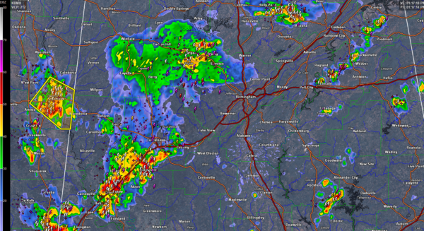
Several clusters of heavy thunderstorms are pushing southeastward across North Central Alabama this afternoon. One cluster is over Blount County and will move into northeastern St. Clair and Etowah Counties in the next hour.
Another cluster is over southeastern Walker County, near Empire and Sumiton. This cluster will will affect parts of Jefferson County over the next 90 minutes.
A cluster near Columbus MS has prompted a severe thunderstorm warning for Lowndes County MS. This storms will affect Macedonia, Reform and Carrollton in Pickens County over the next 30 minutes to one hour.
The largest and strongest cluster in Alabama is over southwestern Tuscaloosa, Greene and Hale Counties. It is pushing southeast and will affect southern Tuscaloosa, much of Hale, southwestern Bibb, Perry and into southwestern Chilton County over the next 90 minutes.
Isolated storms are near Jacksonville, Lincoln, north of Wedowee and west of Dadeville.
ALl of the storms are producing tremendous lightning and heavy rain. Winds gusts of 40-50 mph are possible with them as well. Also, the damaging wind potential is rather high across Central Alabama today for any storms that really can build high into the atmosphere.
Category: Alabama's Weather, ALL POSTS
About the Author (Author Profile)
Bill Murray is the President of The Weather Factory. He is the site's official weather historian and a weekend forecaster. He also anchors the site's severe weather coverage. Bill Murray is the proud holder of National Weather Association Digital Seal #0001 @wxhistorianSubscribe
If you enjoyed this article, subscribe to receive more just like it.


