North Alabama Stays Dry Today
PLEASANT MORNING: An unusually dry airmass for July remains over North Alabama, and it feels pretty good this morning. Our friend Vic Bell at Black Creek, in Etowah County just northeast of Gadsden, reports a cool 58 degrees just before daybreak. The temperature has dropped to 61 at Cullman and Fort Payne.
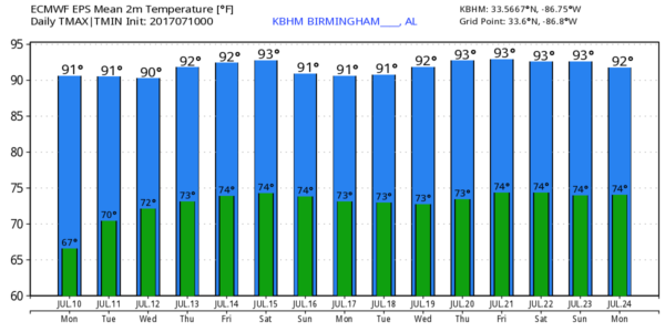
Today will stay shower-free for the northern half of the state thanks to that dry air; afternoon and evening showers and storms will be confined generally south of a line from Livingston to Clanton to Roanoke. The high today will be up in the low 90s in most spots, right at average values for mid July in Alabama.
MID-WEEK: Moist air slowly moves northward. A few afternoon storms are possible tomorrow as far north as I-20 (Tuscaloosa-Birmingham-Anniston), and then by Wednesday and Thursday all of Alabama will have the risk of “scattered, mostly afternoon and evening showers and thunderstorms”… which is what you hear in the forecast almost daily in July and August. Otherwise, partly sunny with high in the low 90s.
FRIDAY AND THE WEEKEND: For now we will roll with a persistence forecast. Standard summer weather, with lots of morning sunshine, and the risk of a passing afternoon/evening shower or storm. A weak surface front could bring an increase in the number of storms to the northern counties Saturday and Sunday. Highs for the weekend should be at or just over 90 degrees.
NEXT WEEK: Not much change; fairly routine summer weather should continue with the usual mix of sun and scattered afternoon storms. Highs will hold mostly in the low 90s. See the Weather Xtreme video for maps, graphics, and more details.
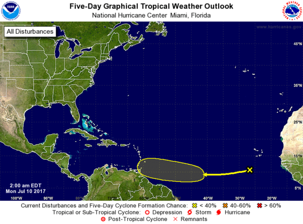
TROPICS: A weak wave in the far eastern Atlantic could show some slow development later this week as it moves westward, but NHC gives it only a 20 percent chance of developing over the next five days. The GFS, famous for bogus tropical systems in the medium range (10-15 days), shows a significant tropical system near Fort Lauderdale late next week, but the reliable European model shows nothing.
AT THE BEACH: Phone apps are worthless in summer when it comes to checking weather on the Gulf Coast. For now it looks like your typical mix of sun and a few scattered storms through the weekend. Click here to see the AlabamaWx Beach Forecast Center page. The Beach Forecast is partially underwritten by the support of Brett/Robinson Vacation Rentals in Gulf Shores and Orange Beach. Click here to see Brett/Robinson’s Own Your Summer specials now!
WEATHER BRAINS: Don’t forget you can listen to our weekly 90 minute netcast anytime on the web, or on iTunes. This is the show all about weather featuring many familiar voices, including our meteorologists here at ABC 33/40. We will produce this week’s show tonight at 8:30 CT… you can watch it live here.
CONNECT: You can find me on all of the major social networks…
Facebook
Twitter
Google Plus
Instagram
Pinterest
Snapchat: spannwx
Look for the next Weather Xtreme video here by 4:00 this afternoon… enjoy the day!
Category: Alabama's Weather, ALL POSTS, Weather Xtreme Videos


