

Mid Afternoon Radar Update
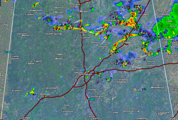
Numerous showers and storms are ongoing across portions of eastern and northern Alabama, and we are also beginning to see additional storms develop across Central Alabama. The general movement of the storms is towards the south today, mainly due to a weak front boundary to the north trying to work into the state.
Any storm today will be producing copious amounts of rain, which could lead to isolated flash flooding in localized areas. Storms are also producing gusty winds and perhaps small hail. However, the most dangerous threat from the storms will be lightning. High instability values in place due to the hot and humid air mass is allowing for very robust updrafts which is allowing the storms to produce so much lightning.
Through the rest of the afternoon, we are going to continue to see these storms meander about the Alabama landscape and continue to expand in coverage. Storms should remain below severe limits, but of course a storm or two will certainly be capable of reaching severe limits briefly with damaging wind gusts, mainly associated with microbursts.
If your location sees a storm, it will last about an hour or so, and then you can go about your weekend plans. Of course a reminder, if you can hear thunder, you can be struck by lightning, so remember when thunder roars, head indoors…
Category: Alabama's Weather, ALL POSTS
About the Author (Author Profile)
Macon, Georgia Television Chief Meteorologist, Birmingham native, and long time Contributor on AlabamaWX. Stormchaser. I did not choose Weather, it chose Me. College Football Fanatic. @Ryan_StinnetSubscribe
If you enjoyed this article, subscribe to receive more just like it.


