

Severe Thunderstorm Warning Canceled For Parts Of Cherokee County
…THE SEVERE THUNDERSTORM WARNING FOR CHEROKEE COUNTY IS CANCELLED… The storm which prompted the warning has weakened below severe limits, and no longer poses an immediate threat to life or property. Therefore the warning has been cancelled. However gusty winds and heavy rain are still possible with this thunderstorm.
Severe Thunderstorm Warning Issued For Parts Of Cherokee County Until 2:00PM
Jul 15th @ 1:21 pm

The National Weather Service in Birmingham has issued a
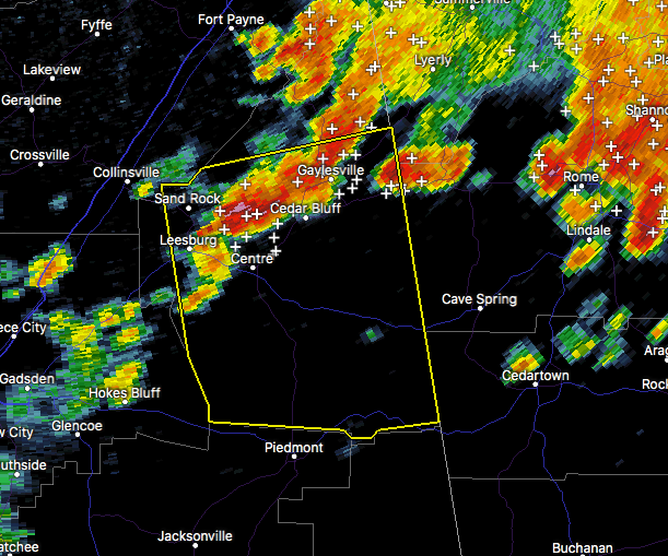
* Severe Thunderstorm Warning for…
Cherokee County in northeastern Alabama…
* Until 200 PM CDT
* At 120 PM CDT, a severe thunderstorm was located near Weiss Lake, or near Centre, moving south at 5 mph.
HAZARD…60 mph wind gusts and quarter size hail.
SOURCE…Radar indicated.
IMPACT…Hail damage to vehicles is expected. Expect wind damage to roofs, siding, and trees.
* Locations impacted include…
Centre, Cedar Bluff, Centre Municipal Airport, Forney, Leesburg, Sand Rock, Gaylesville, Tennala, Pleasant Gap, Cornwall Furnace
Park, Weiss Lake, Moshat, Ball Flat, Coloma, Weiss Dam, Fullerton, Yellow Creek Falls, Chesnut Bay Resort, Spring Garden and Howells
Crossroads.
Category: ALL POSTS, Archived Warnings
About the Author (Author Profile)
Subscribe
If you enjoyed this article, subscribe to receive more just like it.


