

Mostly Sunny And Warm At Midday, A Few Showers Out There
What’s Up With Our Weather At Midday
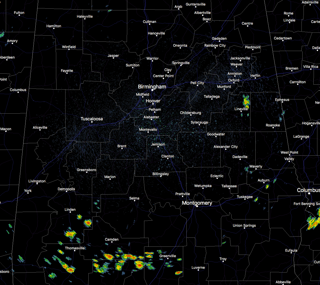
Currently across Central Alabama, we are already starting to see cumulus clouds popping up, making our sky mostly sunny at this point. We do note that there is currently one lone wolf shower over the northeastern part of Clay County. All of the rest of the shower activity is currently located in the extreme southwestern parts of Central Alabama, and down into South Alabama.
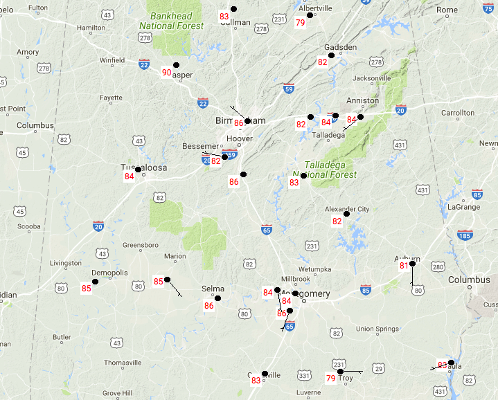
Temperatures across Central Alabama at 11:30 AM are running in the lower to middle 80s at this point, with a few upper 70s out there. Birmingham is currently at 86 degrees, tied with a few others as the warm spot. Troy is coming in as the cool spot at 79 degrees.
The latest sounding from BMX has the convective sounding only at 84 degrees. Most locations in Central Alabama are at least tied with that temperature or already a few degrees warmer. Surface-based instability values are highest in the northern half of the area, topping out a little higher than 3500 J/kg, but all of the areas is above 2000 J/kg. Precipitable water values range from 1.50 inches in the northern parts to near 2.00 inches in the southern parts. This is mainly why development will be more likely to the south due to the more available atmospheric moisture.
One More Day Of Increased Rain Chances
We are still going to have an increased level in shower and storm activity this afternoon and through the early evening hours, before the activity starts diminishing quickly after sunset. Best rain chances will be over the southern half of Central Alabama, around a 1 in 3 chance, with the northern half having a lesser risk and dropping as you continue northward. Afternoon highs will be in the 86-92 degree range throughout the area, with lows tonight in the lower 70s.
Tuesday’s Weather
With ridging starting to set up, the pattern will change to a more typical pattern for mid-Summer. Hot and humid, with a small risk of an isolated shower or storm during the afternoon hours. There will be a slightly higher risk for scattered showers and storms in the extreme southern locations of the area, but for the most part, there will be a 1 in 5 chance of any one location getting any rain north of the I-85 corridor. Highs will be in the upper 80s tot he lower 90s.
Got Beach Plans?
Not much change to the beach forecast… Mainly sunny with temperatures in the upper 80s to the lower 90s along the Gulf, with the typical passing storms moving onshore with the sea breeze. For a detailed look at the weather from Fort Morgan over to Panama City Beach, click here to see the AlabamaWx Beach Forecast Center page.
The Beach Forecast is partially underwritten by the support of Brett/Robinson Vacation Rentals in Gulf Shores and Orange Beach. Click here to see Brett/Robinson’s “Own Your Summer” specials now!
Tropical Outlook
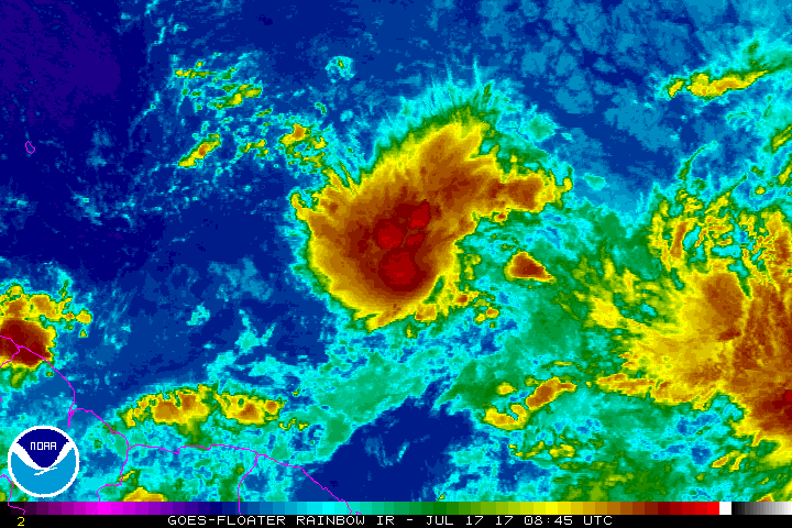
Two areas that need to be watched in the Atlantic… The first is located about 750 miles east of the Windward Islands. Storm activity is showing signs of some organization but still lacks a well-defined center. Aircraft will investigate the cluster this afternoon. Could this be tropical depression “five?” We’ll see. The second wave is located about 800 miles west-southwest of the Cabo Verde Islands. Some gradual development is expected, but chances of tropical cyclone development are very low at this point. Neither system is expected to affect the US mainland.
Today In Weather History
July 17, 1989 – Thunderstorms produced severe weather from South Dakota to Lousiana, with 126 reports of large hail and damaging winds during the day and night. Thunderstorms in Nebraska produced hail four inches in diameter in Frontier County, and at North Platte, causing millions of dollars damage to crops in Frontier County. Thunderstorms in Oklahoma produced wind gusts to 90 mph at Peggs. Tahlequah OK was drenched with 5.25 inches of rain.
WeatherBrains
Don’t forget you can listen to our weekly 90 minute netcast anytime on the web, or on iTunes. This is the show all about weather featuring many familiar voices, including our meteorologists here at ABC 33/40. you can watch it live here on Monday nights at 8:30PM CDT.
Advertise With AlabamaWx… You Can’t Go Wrong
Deliver your message to a highly engaged audience by advertising on the AlabamaWX.com website. The site has already enjoyed 9.6 MILLION page views so far this year alone. Don’t miss out! We can customize a creative, flexible and affordable package that will suit your organization’s needs. Contact Bill Murray at (205) 687-0782.
Category: Alabama's Weather, ALL POSTS
About the Author (Author Profile)
Scott Martin is an operational meteorologist, professional graphic artist, musician, husband, and father. Not only is Scott a member of the National Weather Association, but he is also the Central Alabama Chapter of the NWA president. Scott is also the co-founder of Racecast Weather, which provides forecasts for many racing series across the USA. He also supplies forecasts for the BassMaster Elite Series events including the BassMaster Classic.Subscribe
If you enjoyed this article, subscribe to receive more just like it.


