

It’s Getting Hot Out There At The Midday Hour
What’s Happening With Our Weather As We Approach The Midday Hour
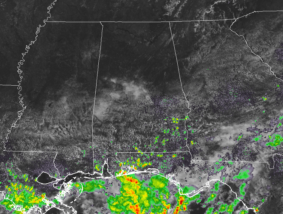
We have mainly clear skies and warm temperatures at the 11 o’clock hour across the northern half of Central Alabama, with partly cloudy skies to the south. There are a few showers that have popped up over the southeastern counties in the area, but these a relatively small at this point. The rest of Central Alabama is dry at this point.
Temperatures Across Central Alabama
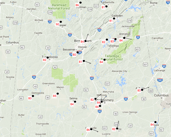
All of the recording stations at the 11 o’clock hour are in the 80s at this point, with the exception of Jasper, which is reading 90 degrees. We believe that this reading is a few degrees higher than what it really is. It’s probably closer to 84 degrees. Cullman is the warm spot at 86 degrees, with a few locations tied as the cool spot at 80 degrees.
What To Expect For The Rest Of The Day
The rest of the day will feature a hot and humid afternoon with a risk of scattered showers and storms. The chances of getting rain are smaller in the northern parts and greater as you travel south. We’ll have a mix of sun and clouds and afternoon highs will be in the upper 80s to the lower 90s. Any rain activity will diminish, but there will be a small risk for a shower or storm over the extreme southern parts of the area. Lows will be in the lower to middle 70s.
Wednesday’s Weather
The ridge builds in and will allow for a dry day for much of Central Alabama. Unfortunately, the ridge will also bring in increased heat levels. We will have a mix of sun and clouds throughout the day with afternoon highs reaching the lower to middle 90s, with the heat index values reaching the 97-102 degree range. There will be a slight risk for isolated showers and storms across the southern portions of the area, mainly south of a line from Demopolis to Clanton to Alexander City. The evening through the overnight hours will be mostly clear, and lows only dropping into the lower to middle 70s.
Got Beach Plans?
For a detailed look at the weather from Fort Morgan over to Panama City Beach, click here to see the AlabamaWx Beach Forecast Center page.
The Beach Forecast is partially underwritten by the support of Brett/Robinson Vacation Rentals in Gulf Shores and Orange Beach. Click here to see Brett/Robinson’s “Own Your Summer” specials now!
Tropical Outlook
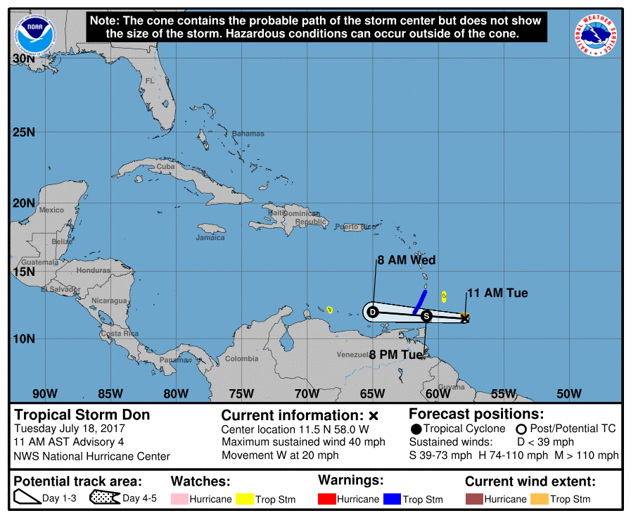
The latest data on Tropical Storm Don has it located about 255 miles east of Grenada and moving to the west at 20 MPH. Maximum sustained winds are at 40 MPH, and the minimum central pressure is at 29.86 inches (1011 mb). Tropical storm watches are up for Barbados and Bonaire, while warnings are up for Grenada and St. Vincent and the Grenadines. Don is not expected to reach hurricane strength and is actually forecast to weaken to an open wave by Thursday due to a harsh environment near the South American coast.
Invest 96L is trailing Don, and forecast models have this system gaining latitude and passing north of the Leeward Islands later this week. Some slow strengthening is expected over the next few days, but the overall outlook doesn’t look favorable.
Today In Weather History
July 18, 1986 – One of the most photogenic tornadoes touched down in the northern suburbs of Minneapolis, MN, during the late afternoon. The very slow moving tornado actually appeared live on the evening news by way of an aerial video taken by the KARE-TV helicopter crew. The tornado, unlike most, was quite the prima donna, staying visible to tens of thousands of persons for thirty minutes. It was moderate in intensity, with winds of 113-157 mph, and caused 650 thousand dollars damage.
WeatherBrains
Don’t forget you can listen to our weekly 90 minute netcast anytime on the web, or on iTunes. This is the show all about weather featuring many familiar voices, including our meteorologists here at ABC 33/40. you can watch it live here on Monday nights at 8:30PM CDT.
Advertise With AlabamaWx… You Can’t Go Wrong
Deliver your message to a highly engaged audience by advertising on the AlabamaWX.com website. The site has already enjoyed 9.6 MILLION page views so far this year alone. Don’t miss out! We can customize a creative, flexible and affordable package that will suit your organization’s needs. Contact Bill Murray at (205) 687-0782.
Category: Alabama's Weather, ALL POSTS
About the Author (Author Profile)
Scott Martin is an operational meteorologist, professional graphic artist, musician, husband, and father. Not only is Scott a member of the National Weather Association, but he is also the Central Alabama Chapter of the NWA president. Scott is also the co-founder of Racecast Weather, which provides forecasts for many racing series across the USA. He also supplies forecasts for the BassMaster Elite Series events including the BassMaster Classic.Subscribe
If you enjoyed this article, subscribe to receive more just like it.


