

Hot & Steamy, With Showers Out There At Midday
How’s Our Weather At Midday
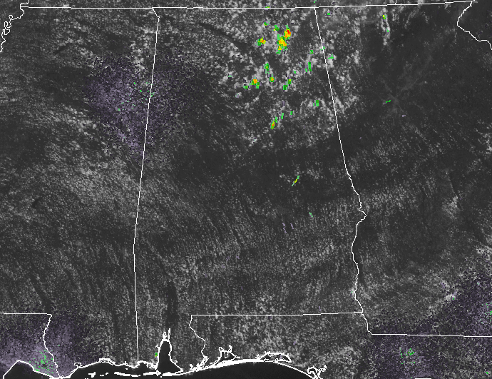
Showers and storms have already fired up in the northeastern parts of Central Alabama at the midday hour. The main concentration of these in our area at this point is located over parts of Blount, Etowah, and Cherokee counties. These are progressing slowly to the south.
Temperatures at 12:00 PM
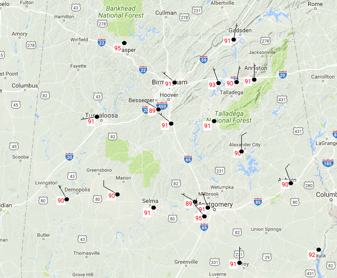
At the midday hour, it is an already hot and steamy day across Central Alabama. Current temperatures are running in the 89-95 degree range, with Montgomery already at 95 degrees. The cool spot is currently Bessemer at 89 degrees. Dew points out there are in the 72-76 degree range, making the heat index values nearing the 100-degree mark in some spots.
Hot And Uncomfortable Conditions For Today
Higher dew points along with the eastern edge of a 594 MB heat bubble over Central Alabama will allow our afternoon highs to reach the middle 90s, with the heat index values in the 99-105 degree range. Skies are expected to stay mostly clear for the most part, and we’ll have a small risk for isolated showers and storms throughout much of the area. There will be a slightly higher risk for scattered showers and storm in the northeastern parts, mainly east of I-65 and north of I-20.
Any shower or storm activity that is out there this afternoon should mostly dissipate before sunset, but one or two could linger just a little bit longer. All should be gone by the 10 o’clock hour, but it will remain muggy throughout the overnight hours. Lows will be in the lower to middle 70s.
Almost The Same For Tomorrow… Slightly Higher Rain Chances
Pretty much the same story for tomorrow… Hot and muggy, with a risk for scattered afternoon showers and storms. Coverage of these will be a little higher, and so will be the rain chances. Afternoon highs will be in the lower to middle 90s. Heat index values will once again be in the 99-105 degree range.
Heading To The Beach
A decent supply of sunshine each day from today through Wednesday, with the daily risk of showers and storms. Highs in the upper 80s to near 90 degrees on the beach, with lower to mid-90s inland. For a detailed look at the weather from Fort Morgan over to Panama City Beach, click here to see the AlabamaWx Beach Forecast Center page.
The Beach Forecast is partially underwritten by the support of Brett/Robinson Vacation Rentals in Gulf Shores and Orange Beach. Click here to see Brett/Robinson’s Own Your Summer specials now!
A Look At The Tropics
The Atlantic basin is very quiet, and mostly covered in dry air coming off the African continent, and tropical storm formation is not expected over the next five days.
Today In Weather History
July 20, 1989 – Showers and thunderstorms in the Middle Atlantic Coast Region soaked Wilmington, DE, with 2.28 inches of rain, pushing their total for the period May through July past the previous record of 22.43 inches. Heavy rain over that three month period virtually wiped out a 16.82-inch deficit which had been building since drought conditions began in 1985. Thunderstorms in central Indiana deluged Lebanon with 6.50 inches of rain in twelve hours, and thunderstorms over Florida produced wind gusts to 84 mph at Flagler Beach.
Category: Alabama's Weather, ALL POSTS
About the Author (Author Profile)
Scott Martin is an operational meteorologist, professional graphic artist, musician, husband, and father. Not only is Scott a member of the National Weather Association, but he is also the Central Alabama Chapter of the NWA president. Scott is also the co-founder of Racecast Weather, which provides forecasts for many racing series across the USA. He also supplies forecasts for the BassMaster Elite Series events including the BassMaster Classic.Subscribe
If you enjoyed this article, subscribe to receive more just like it.


