

Heat Levels Slowly Back Off Over The Weekend
RADAR CHECK: We have a few scattered showers and storms on radar at daybreak… across parts of Central and South Alabama; they are moving southwest, rotating around the “ring of fire” on the periphery of the heat bubble over the Central U.S.
The heat will headline the forecast again today across our state; for North/Central Alabama, highs will be mostly in the mid 90s, with upper 90s to the north over the Tennessee Valley, where a “heat advisory” has been issued by the NWS Huntsville. The best chance of scattered showers and storms this afternoon and early tonight will be along and south of I-20.
THE ALABAMA WEEKEND: The air aloft will be a bit cooler, making conditions more unstable, and that will open the door for a slow increase in the number of scattered showers and thunderstorms. Chance of any one spot seeing a shower or storm will rise from about 35 percent tomorrow, to 50/60 percent Sunday. Most of the thunderstorms will come from 1 until 8 p.m… although we can’t totally rule out a late night or morning shower. Storms over the weekend will be random and scattered, and no way to know exactly when and where they pop up in advance.
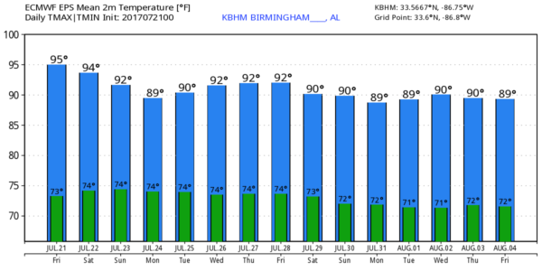
Heat levels will slowly back off; we project low 90s tomorrow, and a high Sunday between 88 and 91 degrees.
NEXT WEEK: Looks like the highest coverage of showers and storms will come Monday and Tuesday, with thunderstorms becoming more scattered in nature Wednesday through Friday. Highs for the week will stay between 88 and 92 degrees for most communities. See the Weather Xtreme video for maps, graphics, and more details.
TROPICS: All remains very quiet across the Atlantic basin, and tropical storm formation is not expected through next week.
BEACH FORECAST: Click here to see the AlabamaWx Beach Forecast Center page. The Beach Forecast is partially underwritten by the support of Brett/Robinson Vacation Rentals in Gulf Shores and Orange Beach. Click here to see Brett/Robinson’s Own Your Summer specials now!
WEATHER BRAINS: Don’t forget you can listen to our weekly 90 minute netcast anytime on the web, or on iTunes. This is the show all about weather featuring many familiar voices, including our meteorologists here at ABC 33/40.
CONNECT: You can find me on all of the major social networks…
Facebook
Twitter
Google Plus
Instagram
Pinterest
Snapchat: spannwx
Look for the next Weather Xtreme video here by 4:00 this afternoon…. enjoy the day!
Category: Alabama's Weather, ALL POSTS, Weather Xtreme Videos
About the Author (Author Profile)
James Spann is one of the most recognized and trusted television meteorologists in the industry. He holds the AMS CCM designation and television seals from the AMS and NWA. He is a past winner of the Broadcast Meteorologist of the Year from both professional organizations.Subscribe
If you enjoyed this article, subscribe to receive more just like it.


