

Showers Are Isolated This Afternoon
CALM AFTERNOON: After a very active morning with strong storms and flash flooding issues over parts of East Alabama, the radar is pretty quiet this afternoon with only isolated showers across Central Alabama.
An MCV (mesoscale convective vortex) helped to produce slow moving storms that dropped 1-3 inches of rain earlier today across parts of Tallapoosa, Chambers, Lee, and Russell counties. Flash flood warnings were issued, but all of those have expired and the big rains are well to the east now.
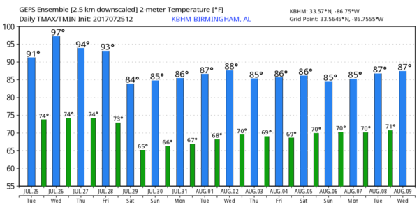
The showers this evening will end once the sun goes down, and we should be dry overnight. Tomorrow, the air will be more stable, and with an increased amount of sun we project a high between 91 and 94 degrees with only widely scattered afternoon thunderstorms.
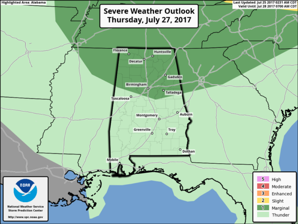
THURSDAY/FRIDAY: Thursday will be another hot, humid summer day with a high in the mid 90s. After morning sunshine, thunderstorms will likely form by mid to late afternoon, and those could pack a punch. SPC maintains a “marginal risk” of severe storms for about the northern half of the state…
Friday will also feature scattered to numerous showers and storms as a surface front approaches the state from the north; Friday’s high will be close to 90.
THE ALABAMA WEEKEND: On Saturday, a number of showers and storms are likely ahead of that surface front, generally along and south of I-20. Understand it won’t rain all day, but a few passing showers and storms are a pretty good possibility over the southern two-thirds of the state. Then, the latest GFS now shows a nice surge of dry, continental air moving into the state Sunday, meaning a mostly sunny and less humid day. Some North Alabama communities could start the day down in the 50s for a nice preview of fall; the high will be in the 80s. A very pleasant day for late July, typically the hottest part of summer.
NEXT WEEK: It now looks like dry air could very well hold in place Monday and Tuesday with highs in the 80s and lows in the 60s… then we will see the typical summer pattern of “scattered, mostly afternoon and evening showers and storms” over the latter half of the week. See the Weather Xtreme video for maps, graphics, and more details.
TROPICS: Dry air covers much of the Atlantic basin, and tropical storm formation is not expected at least for the next five days.
BEACH FORECAST: Click here to see the AlabamaWx Beach Forecast Center page. The Beach Forecast is partially underwritten by the support of Brett/Robinson Vacation Rentals in Gulf Shores and Orange Beach. Click here to see Brett/Robinson’s Own Your Summer specials now!
WEATHER BRAINS: Don’t forget you can listen to our weekly 90 minute netcast anytime on the web, or on iTunes. This is the show all about weather featuring many familiar voices, including our meteorologists here at ABC 33/40.
CONNECT: You can find me on all of the major social networks…
Facebook
Twitter
Google Plus
Instagram
Pinterest
Snapchat: spannwx
Look for the next Weather Xtreme video here by 7:00 a.m. tomorrow…
Category: Alabama's Weather, ALL POSTS, Weather Xtreme Videos
About the Author (Author Profile)
James Spann is one of the most recognized and trusted television meteorologists in the industry. He holds the AMS CCM designation and television seals from the AMS and NWA. He is a past winner of the Broadcast Meteorologist of the Year from both professional organizations.Subscribe
If you enjoyed this article, subscribe to receive more just like it.


