

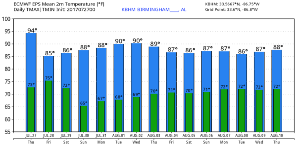
Lower Heat Levels In The Days Ahead; Storms Tomorrow
RADAR CHECK: On this hot humid summer day we have scattered showers and storms mostly over the eastern half of Alabama; they are producing heavy rain, gusty winds, and lots of lightning as they move southeast…
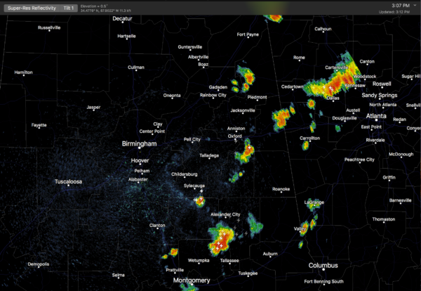
Parts of Elmore and Tallapoosa Counties are under a severe thunderstorm warning as I write this at 3:15p CT.
Away from the storms, temperatures are mostly between 92 and 95 degrees with a partly sunny sky. Scattered storms will end this evening after the sun goes down.
TOMORROW: A rare mid-summer surface front will approach from the north, and bring scattered to numerous showers and storms to the northern half of the state. Some of the storms will pack a punch; SPC maintains a “marginal risk” of severe storms for roughly the northern half of Alabama.
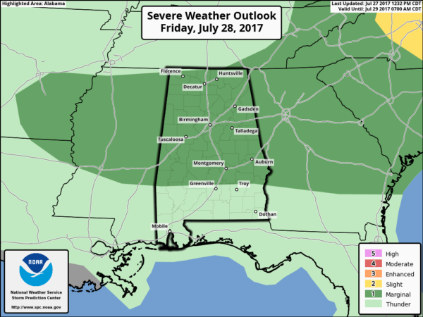
The main threat from the heavier storms will come from strong straight line winds as the move southward. Rain could be heavy; NWS Birmingham has issued a flash flood watch for Bibb, Blount, Calhoun, Cherokee, Clay, Cleburne, Etowah, Fayette, Jefferson, Lamar, Marion, Pickens, Randolph, Shelby, St. Clair, Talladega, Tuscaloosa, Walker, and Winston counties for tomorrow and tomorrow night.
The high tomorrow will drop back into the mid to upper 80s because of clouds and showers.
THE ALABAMA WEEKEND: A rather refreshing airmass for mid-summer drops into the state. On Saturday, North and Central Alabama will be dry and less humid; showers and storms remain possible over the southern counties of the state, and SPC has a “marginal risk” of severe weather defined there. Sunday will feature sunshine in full supply statewide with low humidity for late July… we project a high in the upper 80s both days. Also, Sunday morning will feel pretty good with potential for upper 50s across the cooler pockets across North Alabama.
NEXT WEEK: Monday morning will offer another preview of fall, with potential for upper 50s across North Alabama. The weather stays dry Monday and Tuesday with a good supply of sunshine both days, then we will bring back the usual risk of “scattered, mostly afternoon and evening showers and storms” Wednesday through Friday. Highs for the week will be mostly in the 87-90 degree range, below average for early August.
TROPICS: A weak tropical wave over the eastern Atlantic could show some slow organization over the next five days, but the air in the region is dryer and development, if any, will be very gradual. The rest of the Atlantic basin is quiet.
BEACH FORECAST: Click here to see the AlabamaWx Beach Forecast Center page. The Beach Forecast is partially underwritten by the support of Brett/Robinson Vacation Rentals in Gulf Shores and Orange Beach. Click here to see Brett/Robinson’s Own Your Summer specials now!
WEATHER BRAINS: Don’t forget you can listen to our weekly 90 minute netcast anytime on the web, or on iTunes. This is the show all about weather featuring many familiar voices, including our meteorologists here at ABC 33/40.
CONNECT: You can find me on all of the major social networks…
Facebook
Twitter
Google Plus
Instagram
Pinterest
Snapchat: spannwx
Look for the next Weather Xtreme video here by 7:00 a.m. tomorrow…
Category: Alabama's Weather, ALL POSTS, Weather Xtreme Videos
About the Author (Author Profile)
James Spann is one of the most recognized and trusted television meteorologists in the industry. He holds the AMS CCM designation and television seals from the AMS and NWA. He is a past winner of the Broadcast Meteorologist of the Year from both professional organizations.Subscribe
If you enjoyed this article, subscribe to receive more just like it.


