

Showers/Storms Today; Dry Air For The Weekend
FLASH FLOOD WATCH: NWS offices in Birmingham and Huntsville continue a flash flood watch for roughly the northern half of the state today as a surface front slices into a very moist airmass with high precipitable water values…

A few spots (not everyone) will see rain amounts of 1 to 2 inches through tonight with some flooding possible with the heavier downpours.
Rain is falling early this morning over much of Northwest Alabama, and we will forecast occasional showers and thunderstorms through tonight with a mostly cloudy sky. On the positive side, SPC has now dropped the severe weather risk for most of the state; only the far northern counties are in a “marginal risk”. We won’t get past the mid 80s today, which will limit instability and reduce any risk of severe storms.
THE WEEKEND: The surface front will be close to U.S. 80 tomorrow morning, meaning showers and storms will be confined to the southern quarter of Alabama, where SPC maintains a “marginal risk” of severe weather. Drier air will move into North/Central Alabama; early morning clouds will give way to a partly to mostly sunny day with lower humidity levels. Then, on Sunday, dry air will cover all of the state and we will enjoy sunshine in full supply. The high both days will be in the upper 80s, not bad at all for the hottest part of summer. And, a few spots over North Alabama could see upper 50s early Sunday morning for a little preview of fall.
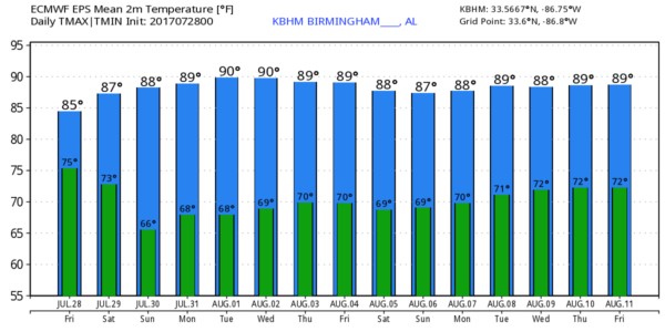
NEXT WEEK: Dry air should hold Monday and Tuesday with mostly sunny warm days and clear pleasant nights. We could see a few isolated showers Wednesday and Thursday, but for now it looks like the highest coverage of showers and storms will come at the end of the week on Friday. Temperatures will stay below average, with highs generally between 87 and 90. See the Weather Xtreme video for maps, graphics, and more details.
TROPICS: A tropical wave in the mid-Atlantic continues to fight dry air, and development, if any, will be slow. The rest of the Atlantic basin is quiet.
BEACH FORECAST: Click here to see the AlabamaWx Beach Forecast Center page. The Beach Forecast is partially underwritten by the support of Brett/Robinson Vacation Rentals in Gulf Shores and Orange Beach. Click here to see Brett/Robinson’s Own Your Summer specials now!
WEATHER BRAINS: Don’t forget you can listen to our weekly 90 minute netcast anytime on the web, or on iTunes. This is the show all about weather featuring many familiar voices, including our meteorologists here at ABC 33/40.
CONNECT: You can find me on all of the major social networks…
Facebook
Twitter
Google Plus
Instagram
Pinterest
Snapchat: spannwx
Look for the next Weather Xtreme video here by 4:00 this afternoon… enjoy the day!
Category: Alabama's Weather, ALL POSTS, Weather Xtreme Videos
About the Author (Author Profile)
James Spann is one of the most recognized and trusted television meteorologists in the industry. He holds the AMS CCM designation and television seals from the AMS and NWA. He is a past winner of the Broadcast Meteorologist of the Year from both professional organizations.Subscribe
If you enjoyed this article, subscribe to receive more just like it.


