

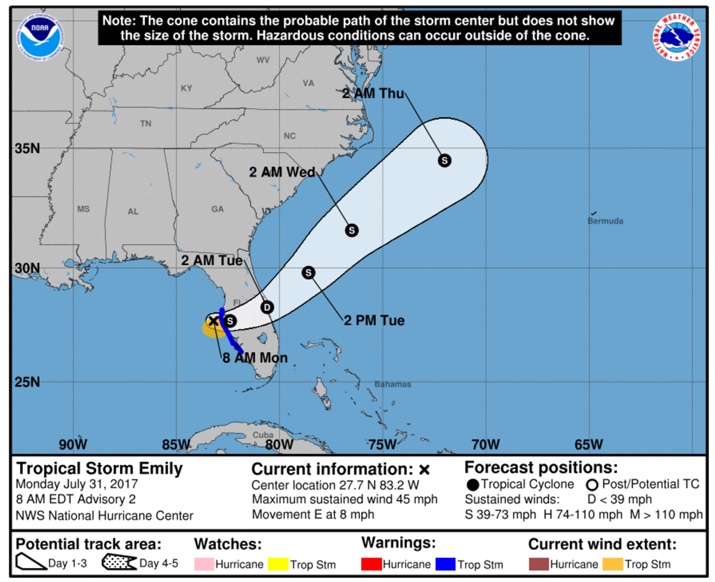
Depression Becomes A Tropical Storm West Of Tampa Bay
SUMMARY OF 800 AM EDT…1200 UTC…INFORMATION
———————————————-
LOCATION…27.7N 83.2W
ABOUT 45 MI…75 KM WSW OF TAMPA FLORIDA
ABOUT 50 MI…80 KM WNW OF SARASOTA FLORIDA
MAXIMUM SUSTAINED WINDS…45 MPH…75 KM/H
PRESENT MOVEMENT…E OR 95 DEGREES AT 8 MPH…13 KM/H
MINIMUM CENTRAL PRESSURE…1006 MB…29.71 INCHES
WATCHES AND WARNINGS
——————–
CHANGES WITH THIS ADVISORY:
A Tropical Storm Warning has been issued for the west coast of
Florida from Anclote River southward to Bonita Beach.
SUMMARY OF WATCHES AND WARNINGS IN EFFECT:
A Tropical Storm Warning is in effect for…
* Anclote River to Bonita Beach Florida
A Tropical Storm Warning means that tropical storm conditions are
likely within the warning area, in this case within the next few
hours.
For storm information specific to your area, including possible
inland watches and warnings, please monitor products issued by your
local National Weather Service forecast office.
DISCUSSION AND 48-HOUR OUTLOOK
——————————
At 800 AM EDT (1200 UTC), the center of Tropical Storm Emily was
located near latitude 27.7 North, longitude 83.2 West. Emily is
moving toward the east near 8 mph (13 km/h), and this general motion
is expected to continue today. A turn toward the northeast and an
increase in forward speed are expected tonight or Tuesday. On the
forecast track, the center of Emily is expected to move inland over
the the west-central Florida peninsula later today and move across
central Florida through tonight. Emily is expected to move offshore
of the east-central Florida coast early Tuesday.
NOAA Doppler radar data from Tampa, Florida, indicate that maximum
sustained winds have increased to near 45 mph (75 km/h) with higher
gusts. Little change in strength is forecast until landfall occurs
this afternoon. Emily is expected to weaken to a tropical
depression while it moves across the Florida peninsula tonight.
Tropical-storm-force winds extend outward up to 60 miles (95 km)
from the center.
The estimated minimum central pressure is 1006 mb (29.71 inches).
HAZARDS AFFECTING LAND
———————-
RAINFALL: Emily is expected to produce total rain accumulations of
2 to 4 inches through Monday night along the west coast of central
Florida between the Tampa Bay area and Naples, with isolated amounts
up to 8 inches possible. Elsewhere across central and south Florida,
1 to 2 inches of rain is expected with localized amounts of up to 4
inches possible.
WIND: Tropical storm conditions are likely within the warning area
through this afternoon.
NEXT ADVISORY
————-
Next complete advisory at 1100 AM EDT.
About the Author (Author Profile)
Subscribe
If you enjoyed this article, subscribe to receive more just like it.


