

Late Afternoon Weather Update For Central Alabama
RADAR CHECK
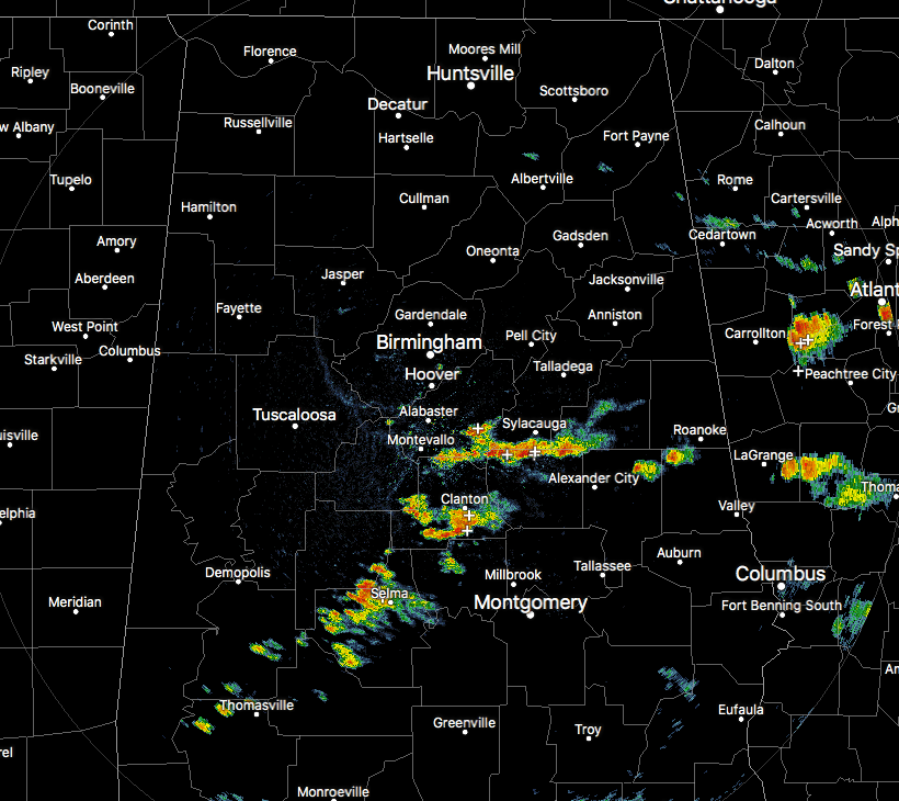
At 3:00 PM, we have scattered showers and thunderstorms across parts of the southern half of Central Alabama, mainly affecting locations such as Columbiana, Talladega Springs, Clanton, Maplesville, and Selma. All of these storms are actually slowly moving to the north. You can expect very heavy rainfall, dangerous cloud-to-ground lightning, and even localized flash flooding.
CURRENT WARNINGS/ADVISORIES
An Urban and Small Stream Flood Advisory is in effect for Central Jefferson County Until 4:30 PM this afternoon.
A Small Stream Flood Advisory is in effect until 4:45 PM this afternoon for Southern Talladega, Northeastern Coosa, and Southwestern Clay counties.
An Urban and Small Stream Flood Advisory for East-Central Dallas County until 5:30 PM this evening.
TEMPERATURES AT 3:00 PM
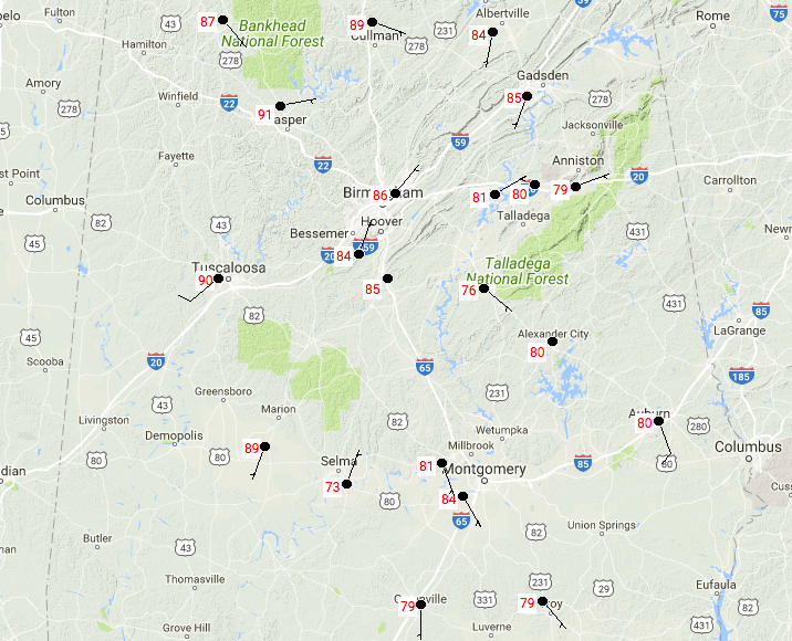
Most locations in the Central Alabama market are currently in the upper 70s to 90 degrees, with a few locations slightly cooler thanks to rain-cooled air. Tuscaloosa was the hot spot at that time at 90 degrees, with Selma as the cool spot at 73 degrees.
REST OF TODAY
We’ll have a mix of clouds and sun throughout the rest of the daytime and into the early evening hours, and few spots will get some showers and thunderstorms, mainly along and south of the I-20 corridor. Highs should top out in the lower 80s to the lower 90. We’ll have partly to mostly cloudy skies throughout the late evening and overnight hours, with a small risk of showers and storms throughout the southeastern parts Central Alabama south of a line from Tuscaloosa to Birmingham to Gadsden, but everyone else will remain dry. Overnight lows will be in the upper 60s to the lower 70s.
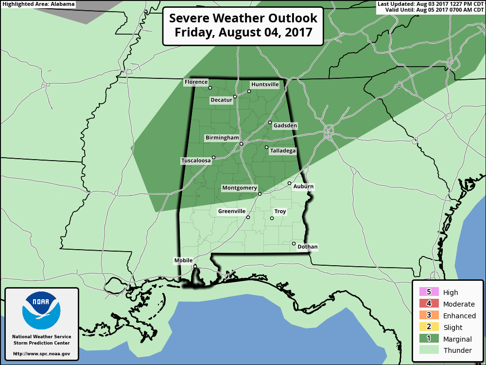
A RARE SUMMERTIME COLD FRONT MOVES IN FOR FRIDAY
Tomorrow will feature more clouds than sun for much of the daytime hours, with a small chance of scattered showers and storms starting early after the morning rush hour. Then an approaching cold front will provide lift for an increased risk of storms starting in the northwestern corner of Central Alabama around noon. At that same time, scattered to numerous storms will begin to form in the extreme southern parts of the area. Afternoon highs will be in the mid to upper 80s.
The Storm Prediction Center has placed nearly all of the area in a Marginal Risk for severe storms in their Day 2 Outlook. The main threats will be from damaging wet microburst winds and some small hail, but with storms expected along the Gulf Coast and into the southern parts of the state, this will keep the main flow of energy from reaching the front and also keeping the severe risk rather low. Even though a small risk of showers and storms will continue into the evening and overnight hours, the strong and severe storm threat will not. Overnight lows will be in the upper 60s to the lower 70s.
THE ALABAMAWX BEACH CENTER FORECAST
Rain and storms are in the forecast in the days ahead. For a detailed look at the weather from Fort Morgan over to Panama City Beach, click here to see the AlabamaWx Beach Forecast Center page.
The Beach Forecast is partially underwritten by the support of Brett/Robinson Vacation Rentals in Gulf Shores and Orange Beach. Click here to see Brett/Robinson’s Own Your Summer specials now!
ADVERTISE WITH THE ALABAMAWX WEATHER BLOG
Now is the time to set your marketing campaign on AlabamaWX. The site has enjoyed a 71% jump in page views this year! The website has already enjoyed 10,157,915 page views this year. We can customize a creative, flexible and affordable package that will suit your organization’s needs. Contact Bill Murray at (205) 687-0782.
E-FORECAST
Get the AlabamaWx seven-day forecast delivered directly to your inbox by email twice daily. It is the most detailed weather forecast available in Central Alabama. Click here to subscribe. It’s free!
ON THIS DAY IN WEATHER HISTORY
1989 – Thunderstorms representing what remained of Hurricane Chantal drenched Wichita, KS, with 2.20 inches of rain in four hours during the early morning. Thunderstorms developing in Minnesota produced wind gusts to 85 mph at Baudette during the afternoon, and softball size hail at Lake Kabetogama, during the evening. Jamestown, ND, reported a record hot afternoon high of 103 degrees.
WEATHERBRAINS
Check out the show at www.WeatherBrains.com. You can also subscribe on iTunes. You can watch the show live at live.bigbrainsmedia.com on Monday nights starting at 8:30 PM CDT. You will be able to see the show on the James Spann 24×7 weather channel on cable or directly over the air on the dot 2 feed.
Category: Alabama's Weather, ALL POSTS
About the Author (Author Profile)
Scott Martin is an operational meteorologist, professional graphic artist, musician, husband, and father. Not only is Scott a member of the National Weather Association, but he is also the Central Alabama Chapter of the NWA president. Scott is also the co-founder of Racecast Weather, which provides forecasts for many racing series across the USA. He also supplies forecasts for the BassMaster Elite Series events including the BassMaster Classic.Subscribe
If you enjoyed this article, subscribe to receive more just like it.


