

Heavy Rain Moving In At The Midday Hour
Check On Our Weather Situation At Noon
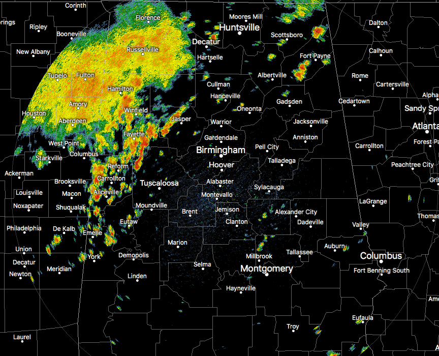
Much of the activity at this point is located over the northern half of Central Alabama mainly north of the I-20 and I-20/59 corridors. The heaviest activity is located on the southern-leading edge of the rain mass currently affecting locations from Arley in southeastern Winston County down through Gordo and Reform in Pickens County, and into the northern parts of Sumter County. Just behind that, a large shield of moderate to heavy rainfall stretches from the northwest corner of the state all of the way back into the northwestern parts of Mississippi. There are a few scattered showers elsewhere, but these are the ones of concern at this point.
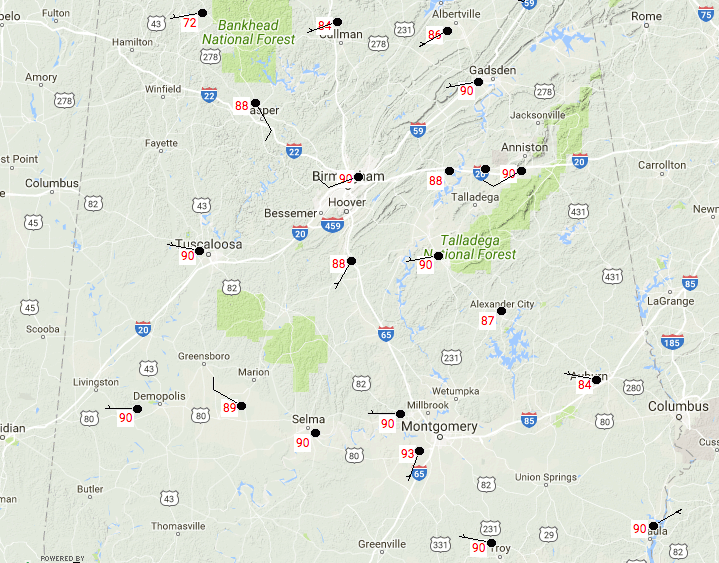
It is a toasty day out there so far where the rain and cloud cover hasn’t arrived yet. Birmingham is currently sitting at 90 degrees, while the rest of Central Alabama is ranging between the lower 70s with rainfall to the lower 90s with mostly clear skies.
Weather For The Rest Of Your Monday
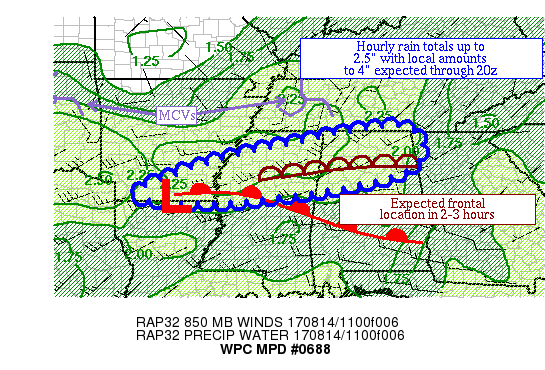
Training of showers and thunderstorms are expected to occur across the northern half of Alabama throughout the afternoon hours especially through 3:00 PM. Rainfall amounts in some areas could reach as high as up to 4 inches, but most locations could see 1.50 to 2.50 inches. So there is a risk for localized flash flooding throughout the afternoon hours. We have a cap in place over much of the area at this point, but afternoon heating will erode that away and allow for more convective showers and storms to develop. The good new is that the risk for severe weather is very low today, but with summertime thunderstorms, you need to “expect the unexpected.” A few storms could be strong with gusty winds being the main threat. Afternoon highs today will be in the mid-80s to the lower 90s across the area. We’ll still have a risk of a few showers and storms during the late night and overnight hours but will diminish as time progresses. Lows will be in the lower to mid-70s.
More Showers And Storms For Tomorrow
We’ll have another shortwave move through the area during the late night hours tonight and into the early morning hours on Tuesday that will likely keep our shower and thunderstorm chances elevated throughout the day. It will be another day where there could be the possibility of localized flash flooding due to cell training and heavy rainfall. When it’s not raining, skies will be mostly cloudy. Afternoon highs will be in the mid-80s to the lower 90s once again.
Taking A Peek At The Tropics
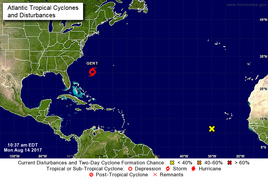
Well, Gert is on the board as of now, but she will eventually become a fish storm as she curves out to the open Atlantic by Tuesday evening. We’ll be keeping our eye on the next area of concern located to the southwest of the Cabo Verde Islands. I’ve seen a few model runs that may have this coming towards the southeastern US. We’ll keep our eyes on it. It has a 60% chance of development within the next 5 days. If named, it would be Harvey.
Stay up-to-date with “The Latest On The Tropics…” running post in the Tropical Weather category on the AlabamaWx Weather Blog home page.
Today In Weather History
August 14, 1987 – Slow moving thunderstorms deluged northern and western suburbs of Chicago IL with torrential rains. O’Hare Airport reported 9.35 inches in 18 hours, easily exceeding the previous 24-hour record of 6.24 inches. Flooding over a five day period resulted in 221 million dollars damage. It was Chicago’s worst flash flood event, particularly for northern and western sections of the city. Kennedy Expressway became a footpath for thousands of travelers to O’Hare Airport as roads were closed. The heavy rains swelled the Des Plaines River above flood stage, and many persons had to be rescued from stalled vehicles on flooded roads.
Advertise With Us!
Now is the time to set your marketing campaign on AlabamaWX. The site has enjoyed a 71% jump in page views this year! The website has already enjoyed 10,157,915 page views this year. We can customize a creative, flexible and affordable package that will suit your organization’s needs. Contact Bill Murray at (205) 687-0782.
E-Forecast
Get the AlabamaWx seven-day forecast delivered directly to your inbox by email twice daily. It is the most detailed weather forecast available in Central Alabama. Click here to subscribe. It’s free!
WeatherBrains
Check out the show at www.WeatherBrains.com. You can also subscribe on iTunes. You can watch the show live at live.bigbrainsmedia.com on Monday nights starting at 8:30 PM CDT. You will be able to see the show on the James Spann 24×7 weather channel on cable or directly over the air on the dot 2 feed.
Category: Alabama's Weather, ALL POSTS
About the Author (Author Profile)
Scott Martin is an operational meteorologist, professional graphic artist, musician, husband, and father. Not only is Scott a member of the National Weather Association, but he is also the Central Alabama Chapter of the NWA president. Scott is also the co-founder of Racecast Weather, which provides forecasts for many racing series across the USA. He also supplies forecasts for the BassMaster Elite Series events including the BassMaster Classic.Subscribe
If you enjoyed this article, subscribe to receive more just like it.


