

Moisture Levels Slowly Rise In Coming Days
**No afternoon Weather Xtreme video today due to eclipse coverage… back to the two a day schedule tomorrow**
NICE DAY FOR AN ECLIPSE: As expected, most people across North/Central Alabama had a great setup for viewing the solar eclipse today. Scattered cumulus clouds, no showers. The temperature at the Birmingham Airport dropped from 91 to 88 degrees during the eclipse; the drop was more pronounced in the path of totality over Tennessee.
This is one of the best shots I have seen today… photo below is from Barry Butler, taken in Southern Illinois…

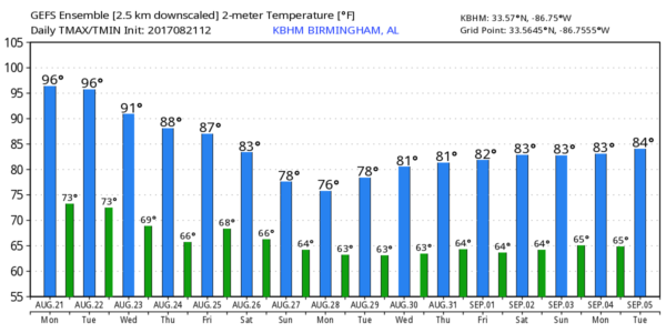
REST OF THE WEEK: Moisture levels will slowly rise, and a few scattered showers or thunderstorms are possible tomorrow afternoon. Coverage of showers will be higher Wednesday as a surface front approaches from the north.
The latest model data suggests that surface front will hang up somewhere over North Alabama Wednesday night, and we will need to maintain some risk of scattered showers and storms Thursday and Friday as well. The most numerous ones should be over the southern half of the state. Highs drop back into the 80s over the latter half of the week.
THE ALABAMA WEEKEND: Looks like a case of scattered, mostly afternoon and evening showers and thunderstorms Saturday and Sunday with highs in the 80s along with a mix of sun and clouds.
Models suggest some cooler air (for late August) will creep into North Alabama next week; highs could drop into the lower 80s Monday and Tuesday… maybe even 70s in spots. A reminder we are getting close to the beginning of meteorological fall (September 1).
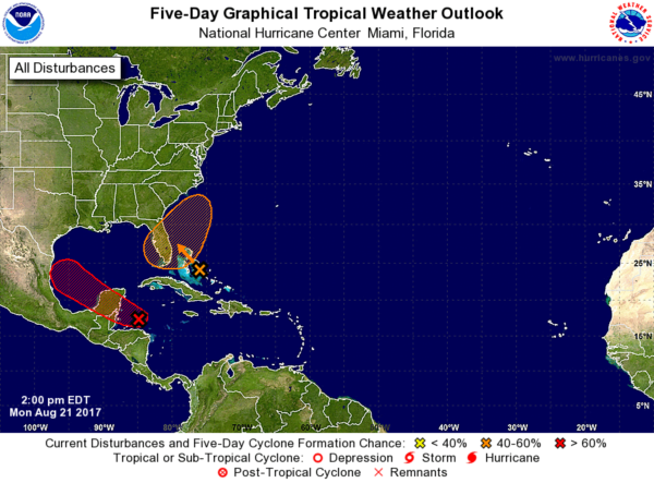
TROPICS: The disturbance formerly known as Tropical Storm Harvey will cross the Yucatan Peninsula over the next 48 hours, and has potential to develop into a tropical storm again later this week. Main threat will come from heavy rain over South Texas late this week.
Another disturbance near the Bahamas will bring the threat of locally heavy rain to parts of the Florida peninsula (not the panhandle) over the next few days before it turns back out into the Atlantic.
No systems are threatening the northern Gulf of Mexico for the next five to seven days.
BEACH FORECAST: Click here to see the AlabamaWx Beach Forecast Center page. The Beach Forecast is partially underwritten by the support of Brett/Robinson Vacation Rentals in Gulf Shores and Orange Beach. Click here to see Brett/Robinson’s Hot Deals now!
WEATHER BRAINS: Don’t forget you can listen to our weekly 90 minute netcast anytime on the web, or on iTunes. This is the show all about weather featuring many familiar voices, including our meteorologists here at ABC 33/40. We will produce this week’s show tonight at 8:30p CT… you can watch it live here.
CONNECT: You can find me on all of the major social networks…
Facebook
Twitter
Google Plus
Instagram
Pinterest
Snapchat: spannwx
Look for the next Weather Xtreme video here by 7:00 a.m. tomorrow…
Category: Alabama's Weather, ALL POSTS
About the Author (Author Profile)
James Spann is one of the most recognized and trusted television meteorologists in the industry. He holds the AMS CCM designation and television seals from the AMS and NWA. He is a past winner of the Broadcast Meteorologist of the Year from both professional organizations.Subscribe
If you enjoyed this article, subscribe to receive more just like it.


