

A Few Heavy Downpours Across Alabama
RADAR CHECK: A few slow moving storms have formed across North/Central Alabama this afternoon producing heavy rain and lots of lightning. Radar data suggests over two inches came down over parts of Southwest Jefferson and North Shelby Counties. Away from the scattered storms, we have a mix of sun and clouds with temperatures in the upper 80s and low 90s.
A surface front will approach tomorrow, and bring a fairly good coverage of showers and storms over the northern half of the state. The sky will be occasionally cloudy with a high in the mid to upper 80s.
THURSDAY/FRIDAY: Drier air will settle into North/Central Alabama on these two days, we expect ample sunshine, lower humidity, and cooler nights. Some of the traditionally cooler spots could see upper 50s early Friday morning. Any showers should be confined to the southern counties of the state.
THE ALABAMA WEEKEND: Moist air returns, and scattered showers and storms are possible statewide Saturday and Sunday. Not much sun, and highs will drop into the low to mid 80s. The amount of rain we see Sunday, and into early next week, will all depend on Harvey, a tropical system that is expected to regenerate in the Southwest Gulf of Mexico tomorrow. Until a low level center is defined, it will be pretty hard to identify the days on which we will have a higher coverage of rain, but generally speaking the pattern looks relatively wet Sunday through at least through the middle of next week.

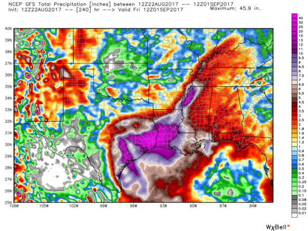
HARVEY TO RETURN: Tropical Storm Harvey degenerated into an open wave over the Caribbean this past weekend, but it is expected to develop again tomorrow over the warm water of the Southwest Gulf. Models are in good agreement that Harvey will move into the Texas coast as a strong tropical storm, or a category one hurricane Friday. The main impact on the Texas coast will come from heavy rain and flooding; unfortunately steering currents look light, and global models are suggesting Southeast Texas, including Houston, could wind up with over two feet of rain from Friday through early next week. Needless to say, this could set up a serious flood threat.
The remnant circulation should finally move northeast early next week, and has the potential to bring lots of rain to states like Mississippi and Alabama, but it remains to be seen just how much we can expect.
INVEST 92L: A broad tropical low near the East Coast of Florida will meander about for a few days, and could develop slowly by the weekend or early next week as it moves northeast over the water of the Atlantic Ocean. If this one gets a name, it will be “Irma”. No impact on Alabama.
BEACH FORECAST: Click here to see the AlabamaWx Beach Forecast Center page. The Beach Forecast is partially underwritten by the support of Brett/Robinson Vacation Rentals in Gulf Shores and Orange Beach. Click here to see Brett/Robinson’s Hot Deals now!
WEATHER BRAINS: Don’t forget you can listen to our weekly 90 minute netcast anytime on the web, or on iTunes. This is the show all about weather featuring many familiar voices, including our meteorologists here at ABC 33/40.
CONNECT: You can find me on all of the major social networks…
Facebook
Twitter
Google Plus
Instagram
Pinterest
Snapchat: spannwx
Look for the next Weather Xtreme video here by 7:00 a.m. tomorrow…
Category: Alabama's Weather, ALL POSTS, Weather Xtreme Videos
About the Author (Author Profile)
James Spann is one of the most recognized and trusted television meteorologists in the industry. He holds the AMS CCM designation and television seals from the AMS and NWA. He is a past winner of the Broadcast Meteorologist of the Year from both professional organizations.Subscribe
If you enjoyed this article, subscribe to receive more just like it.


