

Eyes On Harvey In The Gulf Of Mexico
DRIER AIR MOVING INTO NORTH ALABAMA: Showers and storms have fired along and south of a surface front across Central Alabama; those showers were scattered along the U.S. 80 corridor from Selma to Montgomery to Opelika at mid-afternoon. They will continue to drift southward through the evening hours.
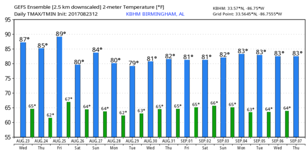
The northern half of Alabama is rain-free, and we expect a good supply of sunshine tomorrow and Friday with lower humidity and cooler nights. Some of the traditionally cooler pockets across North Alabama could see upper 50s early Friday morning for a little preview of fall.
OUR WEEKEND: Moisture levels will rise, and we will mention some risk of showers and thunderstorms Saturday and Sunday. For now it looks like the showers will be fairly scattered in nature as the deep moisture associated with Tropical Storm Harvey remains west of Alabama. The sun will be out at times, and we expect highs in the mid 80s.
Our weather next week all depends on the behavior of Tropical Storm Harvey, and there is considerable uncertainty now. I do think deeper moisture will move into Alabama and the adjacent states at some point; it could be early in the week, or several days later. Model consistency is not especially good in this situation. For now we will just broad brush the forecast with a chance of showers and storms each day; we will fine tune things in coming days as we get better clarity.
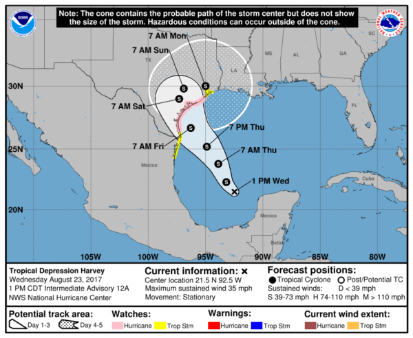
HARVEY HEADED FOR TEXAS: The tropical depression in the Southwest Gulf of Mexico is expected to become a tropical storm over the next 24 hours, ultimately moving into the middle Texas coast Friday. A hurricane watch has been issued on the coast of Texas from north of Port Mansfield to San Luis Pass, although Harvey is expected to remain just under hurricane strength at landfall.
One way or another the main issue will be heavy rain and flooding. Rain amounts of 15-25 inches are likely Friday through Monday across Southeast Texas, including Houston and Galveston, and serious, life threatening flooding could vey well develop. Global model output hints some spots could approach three feet of rain as Harvey meanders around Southeast Texas due to weak steering currents.
INVEST 92L: A broad disturbance over the Florida Peninsula will bring periods of heavy rain over the next few days; it should ultimately move northeast back into the Atlantic, and some slow development is possible this weekend and early next week. If a tropical storm does form here, it will be “Irma”. No impact on Alabama.
See the Weather Xtreme video for maps, graphics, and more details.
BEACH FORECAST: Click here to see the AlabamaWx Beach Forecast Center page. The Beach Forecast is partially underwritten by the support of Brett/Robinson Vacation Rentals in Gulf Shores and Orange Beach. Click here to see Brett/Robinson’s Hot Deals now!
WEATHER BRAINS: Don’t forget you can listen to our weekly 90 minute netcast anytime on the web, or on iTunes. This is the show all about weather featuring many familiar voices, including our meteorologists here at ABC 33/40.
CONNECT: You can find me on all of the major social networks…
Facebook
Twitter
Google Plus
Instagram
Pinterest
Snapchat: spannwx
Look for the next Weather Xtreme video here by 7:00 a.m. tomorrow…
Category: Alabama's Weather, ALL POSTS, Weather Xtreme Videos
About the Author (Author Profile)
James Spann is one of the most recognized and trusted television meteorologists in the industry. He holds the AMS CCM designation and television seals from the AMS and NWA. He is a past winner of the Broadcast Meteorologist of the Year from both professional organizations.Subscribe
If you enjoyed this article, subscribe to receive more just like it.


