

Rain Moves Out; Dry and Cooler Monday
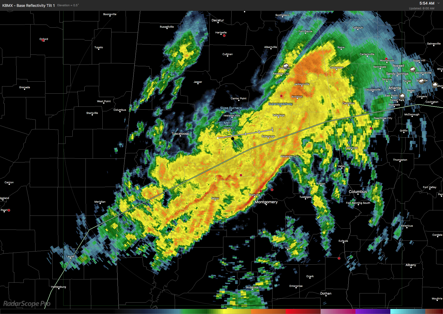
A cold rain blankets a broad area of Alabama about 50 miles wide this morning extending from about 20 miles east of Jacksonville southwestward across Sylacauga to Butler. Temperatures were in the 40s across Central Alabama. The rain along with the upper trough should move out by the late morning and very early afternoon. If the rainfall measurement at my house is any indication – 1.80″ – it does appear that much of Central Alabama has received amounts of 1.5 to 2 inches of rain. This should definitely stunt the growth of drought conditions. Add to that rain events Wednesday and next weekend, and we may see the drought conditions pulled back considerably. Highs today should move upward into the 50s as the rain ceases.
Monday should be dry and cooler as the second trough moves off the East Coast of the US. You can expect to see highs Monday in the lower 50s – just a tad cooler than usual for early February.
But don’t get used to the dry weather. Much of Tuesday will be dry as the next system takes shape with the approach of an upper trough coming out of the Four Corners area. That trough moves quickly into the Mississippi River Valley by midday Wednesday with a surface low forming in Texas and moving northeastward into the southern Appalachians by midday Wednesday. It appears that the first half of Tuesday will be dry as the system begin to develop to our west with rain coming in Tuesday evening and continuing into Wednesday afternoon. With a warm front moving northward across Alabama on Tuesday, temperatures will be fairly nice in spite of the rain with highs in the upper 50 Tuesday and into the lower 60s on Wednesday.
Wednesday we’ll have to be watching for the potential for severe weather. GFS CAPE values surge upward to near 1200 j/kg at midday on Wednesday especially across the southwest portion of Alabama, so while there is no current area defined, we’ll need to maintain a close watch on future model runs to see how they evolve with severe weather parameters.
A broad trough develops across the East Coast on Thursday and slowly migrates into the Atlantic on Friday. Both days should be dry for us with temperatures not too bad. Highs will be in the 50s on Thursday, but as the upper ridge begins to pump up some on Friday we should see highs climb into the 60s.
Saturday a trough moves across Texas in a moisture rich southwesterly upper flow that will transport Pacific moisture into the Southeast US. This should set the stage for a wet weekend with a surface low moving from Texas on Saturday into the Ohio Valley on Sunday. This is way too far out to be specific, but the pattern is suggestive of the potential for some severe weather across the Southeast US. This is another one that we’ll need to keep an eye on to see how it evolves. Southerly flow Saturday should help highs reach to near 60. Sunday will be cooler thanks in part to the rain and clouds as well as the passage of a cold front. But since the upper flow remains southwesterly, we should stay pretty mild with highs Sunday dipping back into the 50s.
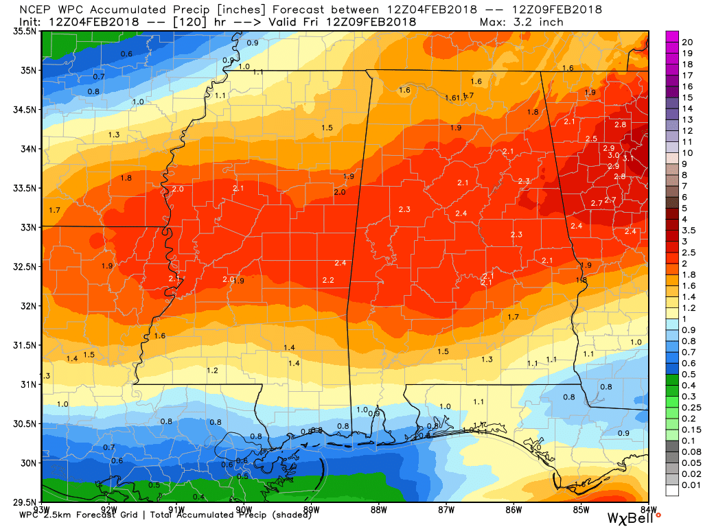
Rainfall amounts for the next 5 days including some of the rain falling this morning should reach the 2 to 3 inch range for a broad swath of Central Alabama. Again, this helps to beat back the growing drought conditions.
Looking into voodoo country, the screaming message is a lack of any extreme cold for the Southeast US. The GFS is pretty bullish on keeping a broad upper ridge over the Gulf of Mexico until around February 18th/19th when it once again develops a fairly deep trough over the eastern US.
Beach Forecast: Click here to see the AlabamaWx Beach Forecast Center page. The Beach Forecast is partially underwritten by the support of Brett/Robinson Vacation Rentals in Gulf Shores and Orange Beach. Click here to see Brett/Robinson’s Hot Deals now!
WeatherBrains: Don’t forget you can listen to our weekly 90 minute netcast anytime on the web, or on iTunes. This is the show all about weather featuring many familiar voices, including our meteorologists here at ABC 33/40.
Thanks for tuning in to the Weather Xtreme Video. James Spann will have the next edition bright and early on Monday morning. I hope that you have a great day. Godspeed.
-Brian-
Category: Alabama's Weather, ALL POSTS, Weather Xtreme Videos
About the Author (Author Profile)
Brian Peters is one of the television meteorologists at ABC3340 in Birmingham and a retired NWS Warning Coordination Meteorologist. He handles the weekend Weather Xtreme Videos and forecast discussion and is the Webmaster for the popular WeatherBrains podcast.Subscribe
If you enjoyed this article, subscribe to receive more just like it.


