

Still Wet but Drier for Monday and Tuesday
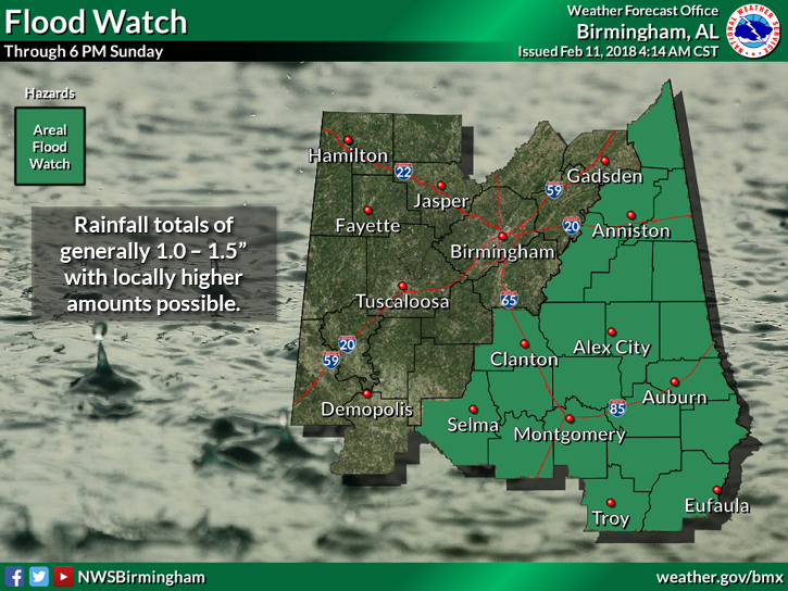
The slow moving surface front we mentioned here yesterday had moved closer this morning as it was about prepared to enter the northwest corner of the state. Much of the heavier rain has moved a bit further to the east, so flash flood watches have been cancelled for the northern and northwestern sections while the watch remained in effect southeast of a line from Anniston to Clanton to Selma along with much of South Central and Southeast Alabama.
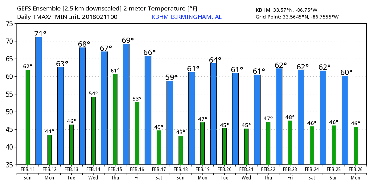
Looks like fairly nice weather for the Mercedes Marathon this morning. Temperatures in the lower 60s with clouds and perhaps a few sprinkles but do not expect to see any significant rain during the event.
Showers possible later today for the Bassmaster Tournament on Lake Martin. Wind out of the south to southwest at 10 to 15 mph today switching to the northwest around sunset. Temperatures mild with highs in the middle 60s.
Clouds will remain in place today but temperatures will be quite mild with highs across Central Alabama in the middle and upper 60s – I don’t expect to see temperatures change much today. SPC maintains a marginal risk outlook for severe weather over the Florida Panhandle and much of Southeast Alabama. CAPE values are forecast to be around 300-400 j/kg over Southeast Alabama this afternoon into the early evening hours.
The front is forecast to move further southeast and out of Alabama by Monday morning, but we’ll still see a good deal of cloudiness with some risk of patchy rain during the morning. Temperatures will fall back some for Monday with highs in the upper 50s.
For the middle of the week, Tuesday through Thursday, the upper air pattern will feature an upper ridge over the Gulf of Mexico. At the surface, it looks like we should see a pretty good case for the wedge with a 1041 millibar high over New York. The GFS keeps us dry and perhaps a little too warm with the MOS guidance suggesting a high of 72. The wedge looks like it could be strong enough to impact the weather in much of eastern Alabama, so we’ll have to monitor how the wedge evolves and perhaps lower highs and increase rain chances.
Wednesday the GFS MOS drops a little with a high of 67 as rain chances ramp up a little as a weak short wave moves across the Tennessee River Valley. By late Thursday and Friday, a cold front is forecast to settle into the Southeast US while the upper ridge maintains a position over the Gulf of Mexico. With a trough over northern Baja California, moisture rish air from the Pacific will be streaming into the Southeast US, so we can expect to see showers with the probability of rain going up. But it is going to remain relatively mild with the overall flow pattern. Some cooler air on Friday will drop the highs into the upper 50s but we should recover into the 60s for the weekend. The weekend looks like it could be showery thanks to the presence of the decaying frontal boundary.
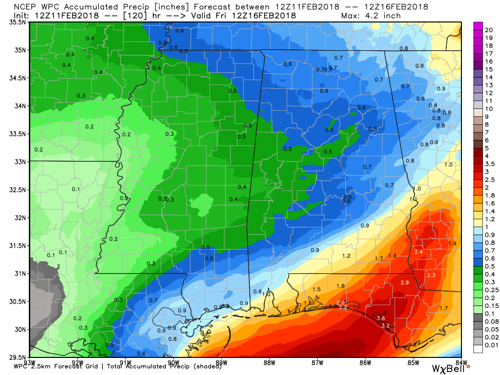
Rainfall over the next five days will be fairly light with values around half an inch.
Looking into Week 2 or voodoo country, a strong upper trough promises some active weather for us around the 20th of February as it moves toward the Middle and Lower Mississippi River Valley. The pattern morphs toward a broad trough from the 20th to the 22nd but without a lot of latitudinal extent. But then we could see a very dramatic warmup with the GFS punching up the ridge over the eastern US as a very deep trough and a closed upper low dive into the Four Corners Area. But you know about voodoo country – here today, gone tomorrow.
Beach Forecast: Click here to see the AlabamaWx Beach Forecast Center page.
WeatherBrains: Don’t forget you can listen to our weekly 90 minute netcast anytime on the web, or on iTunes. This is the show all about weather featuring many familiar voices, including our meteorologists here at ABC 33/40.
Looking forward to staffing the ABC 3340 booth at the World of Wheels at the BJCC this afternoon. I’m planning to be there from about 2 to 4 pm, so be sure to stop by the booth and say hello. James Spann will have the next edition of the Weather Xtreme Video here Monday morning. Have a great day and Godspeed.
-Brian-
.
Category: Alabama's Weather, ALL POSTS, Weather Xtreme Videos
About the Author (Author Profile)
Brian Peters is one of the television meteorologists at ABC3340 in Birmingham and a retired NWS Warning Coordination Meteorologist. He handles the weekend Weather Xtreme Videos and forecast discussion and is the Webmaster for the popular WeatherBrains podcast.Subscribe
If you enjoyed this article, subscribe to receive more just like it.


