

Conditions At Midday In Central Alabama
How Do We Look At 1:00 PM
We have a few high clouds over Central Alabama at this point, but those are not really filtering the bright sunshine on this wonderful Friday afternoon. Temperatures are sitting in the upper 50s to the mid-60s, with Birmingham at 59 degrees.
Weather For The Rest Of Your Friday

Even though we have a few high clouds moving across the area, skies will continue to be mainly sunny throughout the remainder of the afternoon and early evening hours. Afternoon highs will be much higher than yesterday, topping out in the lower to mid-60s throughout Central Alabama. Those clear skies will continue in the latter part of the evening and into the late night hours, but clouds will begin to increase after midnight. Overnight lows will be in the 40s.
Rain Likely By Saturday Afternoon, Stronger Storms Possible In The Southwest
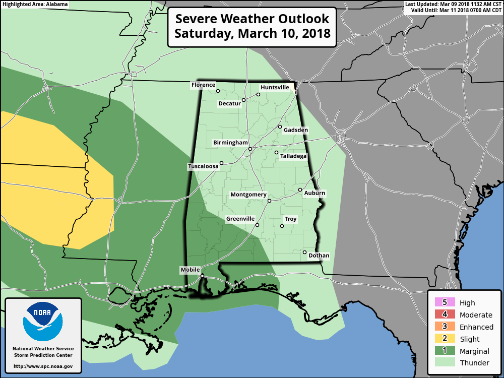
Latest models appear to be keeping much of Central Alabama dry throughout the early morning hours on Saturday, but rain will start to move into the western parts of the area before we reach the beginning of the afternoon. Much of the rain at this point look to be scattered in nature, so don’t expect an all-day rain event, but rain could be expected at any time throughout the afternoon and throughout the evening and late night hours. The good news is at this point it doesn’t look to be a severe storm threat in Central Alabama with the exception of the extreme southwestern locations, as the SPC has a Marginal Risk of severe storms for the area mainly for the late afternoon through the evening hours. This will be a low instability/high shear event, so a brief isolated tornado is possible. Highs will top out in the lower 60s to the mid-70s from northwest to southeast throughout the area, with lows dipping into the lower to mid-50s.
Daylight Saving Time… Time To “Spring Forward”
Don’t forget to set your clocks ahead before you go to bed on Saturday night, as 2 AM Sunday is Daylight Saving Time.
We Continue Cloudy And Wet For Sunday
The good news is that there is no severe threat for anyone in Central Alabama at this time for Sunday, as the more active weather will be along the Gulf Coast stretching from Panama City down to Cape Coral and including the northern 2/3rds of the Florida Peninsula. Showers and a few embedded thunderstorms will continue to move through Central Alabama throughout Sunday morning and well into the afternoon. Coverage of the rainfall will drop some, but a few light scattered showers are possible throughout the remainder of the afternoon and into the night. Highs will be in the lower 60s to the lower 70s from north to south, with lows dropping back into the mid-30s to the lower 40s.
Beach Forecast Center
Don’t you wish you were there, already? Soaking up the rays and wiggling your toes in the sand? Get the latest forecast for the beaches from Fort Morgan to Panama City on our Beach Forecast Center page. There, you can select the forecast of the region that you are interested in.
WeatherBrains
Don’t forget you can listen to our weekly 90 minute netcast anytime on the web at WeatherBrains.com or on iTunes. This is the show all about weather featuring many familiar voices, including the meteorologists at ABC 33/40.
E-Forecast
Get the AlabamaWx Weather Blog’s Seven-Day Forecast delivered directly to your inbox by email twice daily. It is the most detailed weather forecast available in Central Alabama. Subscribe here… It’s free!
Advertise With Us
Don’t miss out! We have enjoyed nearly 3.3 MILLION page views on AlabamaWx.com since the start of 2018. We can customize a creative, flexible and affordable package that will suit your organization’s needs. Contact Bill Murray at (205) 687-0782.
On This Day In Weather History
1956 – A whopping 367 inches of snow was measured on the ground at the Ranier Paradise Ranger Station in Washington. The snow depth was a state record and the second highest total of record for the continental U.S.
Category: Alabama's Weather, ALL POSTS
About the Author (Author Profile)
Scott Martin is an operational meteorologist, professional graphic artist, musician, husband, and father. Not only is Scott a member of the National Weather Association, but he is also the Central Alabama Chapter of the NWA president. Scott is also the co-founder of Racecast Weather, which provides forecasts for many racing series across the USA. He also supplies forecasts for the BassMaster Elite Series events including the BassMaster Classic.Subscribe
If you enjoyed this article, subscribe to receive more just like it.


