

Increasingly Wet and Stormy Through Tomorrow Morning
The big picture at 8:15 p.m. Notice the warnings in Oklahoma and Arkansas. Temperatures across North Central Alabama are in the 50s with showers and embedded thunder.
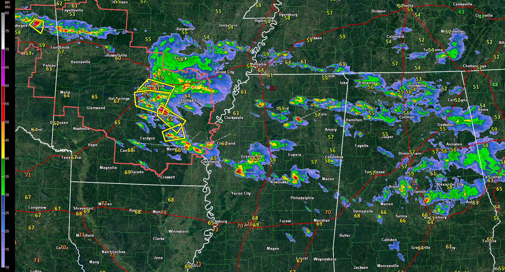
Fairly widespread showers with some embedded thunder are moving across the northern half of Alabama tonight. There is not much surface based instability, but a decent amount of elevated CAPE (aloft), contributing to some loud thunderclaps just south of Birmingham about 30 minutes ago. A surface trough and a zone of significant vorticity are helping to trigger the activity.
The heaviest precipitation is over Bibb, Chilton and northern Autauga counties at this hour, from between Centreville and Maplesville to just north of Prattville. Some heavier cells are southwest of Wetumpka in Elmore County. Most of the activity is pushing east, but sagging a little south with time as well.
Over Mississippi, scattered low topped thunderstorms have formed in a regime of stronger upper-level winds. The strongest storms are in the Delta between Belzoni and Greenwood, north of Jackson.
Storms have become more organized and stronger over North Central Mississippi into northwestern Alabama. Storms are scattered from near Batesville along I-55 to New Albany and Pontotoc to north of Fulton in Mississippi. They are increasing across parts of Marion and Frankin counties into Winston, Lawrence and Morgan counties near Decatur.
There is a brand new severe thunderstorm warning for parts of Northeast Mississippi until 915 p.m. One inch hail was just reported in Lee County, Mississippi. This cell will approach Franklin and Colbert Counties in the next hour.
Back in Arkansas a batch of strong to severe storms extends from the Little Rock area southeastward to Pine Bluff and connects with the activity over western Mississippi near Greenwood. Several severe thunderstorm warnings are in effect over Arkansas back into eastern Oklahoma and a severe thunderstorm watch covers eastern Oklahoma and much of Arkansas.
A stationary front extends from southeastern Oklahoma across Arkansas, Tennessee, Virginia and out through eastern North Carolina. Broad low pressure covers Texas. A strong upper-level trough, now over South Dakota and Nebraska, will rotate southeastward Sunday, reaching western Tennessee by Sunday evening. It will push through Alabama late tomorrow night and Monday morning.
Rain and storms will increase overnight, especially after midnight across Mississippi and western Alabama with heavy rain and thunder likely into the morning hours. The storms could be severe over Mississippi, with a slight risk posted by the SPC for the western part of that state. A marginal risk covers eastern Mississipi and extends into West Central Alabama around Sumter County.
The main activity will push southeast of I-59 between 7-9 a.m. and out of Central Alabama by 1 p.m.
Showers will continue through the afternoon over North and central Alabama as the strong disturbance passes over with its cold air aloft and associated instability. There could be some thunder, but I don’t expect severe weather. There could be strong storms during the afternoon over South Alabama.
The surface low should be near Chattanooga by Sunday evening and the cold front east of I-59. Showers should be out of all but eastern Alabama by daybreak Monday. There could be a brief snow shower over the Tennessee Valley and Northeast Alabama early Monday morning. After today’s highs near 70F, middle 60s will prevail on Sunday and we will get mired in the 50s on Monday. Lows will be near or below freezing Tuesday and Wednesday mornings.
Don’t forget to set your clocks ahead one hour when you go to bed tonight, or you will be late for any Sunday morning activities.
Category: Alabama's Weather, ALL POSTS
About the Author (Author Profile)
Bill Murray is the President of The Weather Factory. He is the site's official weather historian and a weekend forecaster. He also anchors the site's severe weather coverage. Bill Murray is the proud holder of National Weather Association Digital Seal #0001 @wxhistorianSubscribe
If you enjoyed this article, subscribe to receive more just like it.


