

A Few Warnings & Advisories In Effect On Monday
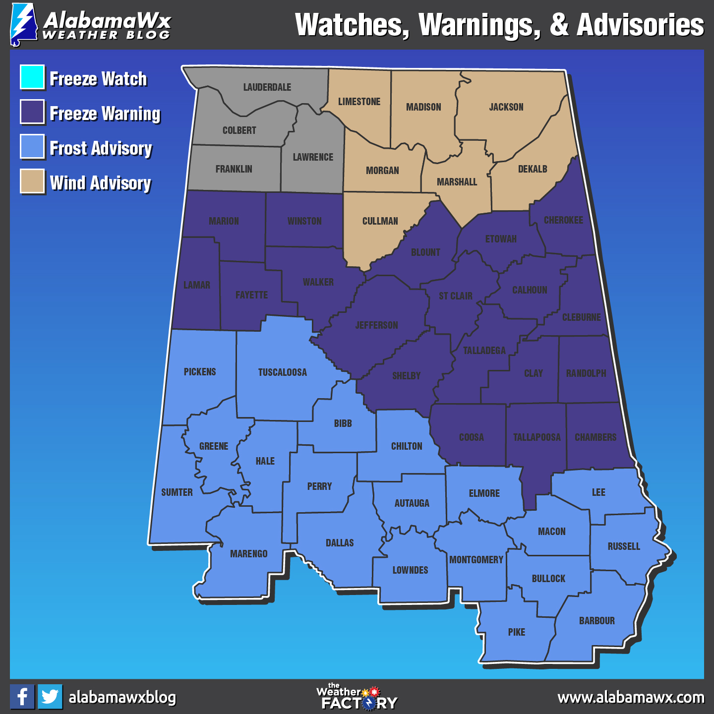
The National Weather Service in Birmingham has issued a Freeze Warning, which is in effect from 3 AM to 9 AM CDT Tuesday. A Wind Advisory has also been issued. This Wind Advisory is in effect from 9 AM this morning to 7 PM CDT this evening. In addition, a Freeze Watch has been issued. This Freeze Watch is in effect from late Tuesday night through Wednesday morning.
An upper low will swing through the area today, allowing winds to pick up to around 20 to 30 mph with higher gusts. These winds will calm down quite substantially this evening and the colder airmass will begin to settle down into the area. This puts the northern half of the area generally at or below freezing. Further south, temperatures will stay above freezing for most of the area but will still be in the low to mid-30s. Dewpoints will remain above 30 in these areas so patchy frost is possible. There could be a few spots in the south that drop to 32 degrees but those will be more isolated than across the north.
TIMING…of the strongest winds will be between 9 AM and 7 PM today. The freezing temperatures will begin around 3 AM in the north overnight.
WINDS…will be sustained at 20 to 30 mph, with gusts up to 35 mph.
TEMPERATURE…will be between 28 and 33 degrees overnight. Then temperatures will be between 25 and 32 degrees by Wednesday morning.
IMPACTS…from the strong winds could cause hazardous driving conditions as well as downed limbs and weak trees. Impacts from the cold temperatures could result in damaging or killing crops and other sensitive vegetation.
Freeze Watch is for all counties in Central Alabama.
Freeze Warning is for Blount, Calhoun, Chambers, Cherokee, Clay, Cleburne, Coosa, Etowah, Fayette, Jefferson, Lamar, Marion, Randolph, Shelby, St. Clair, Talladega, Tallapoosa, Walker, & Winston counties.
Frost Advisory is for Autauga, Barbour, Bibb, Bullock, Chilton, Dallas, Elmore, Greene, Hale, Lee, Lowndes, Macon, Marengo, Montgomery, Perry, Pickens, Pike, Russell, Sumter, & Tuscaloosa counties.
Wind Advisory is for all counties in Central Alabama and for Cullman, De Kalb, Jackson, Limestone, Madison, Marshall, & Morgan counties in North Alabama (issued by NWS Huntsville).
A Wind Advisory means that wind gusts of 35 mph are expected. Winds this strong can make driving difficult…especially for high profile vehicles. Use extra caution.
A Frost Advisory means that widespread frost is expected. Sensitive outdoor plants may be killed if left uncovered.
A Freeze Watch means sub-freezing temperatures are possible. These conditions could kill crops and other sensitive vegetation.
Category: Alabama's Weather, ALL POSTS
About the Author (Author Profile)
Scott Martin is an operational meteorologist, professional graphic artist, musician, husband, and father. Not only is Scott a member of the National Weather Association, but he is also the Central Alabama Chapter of the NWA president. Scott is also the co-founder of Racecast Weather, which provides forecasts for many racing series across the USA. He also supplies forecasts for the BassMaster Elite Series events including the BassMaster Classic.Subscribe
If you enjoyed this article, subscribe to receive more just like it.


